
Talaksan:2010 Pacific typhoon season summary.png

Laki ng pasilip na ito: 800 x 600 na pixel. Ibang mga resolusyon: 320 x 240 na pixel | 640 x 480 na pixel | 1,024 x 768 na pixel | 1,280 x 960 na pixel | 2,560 x 1,920 na pixel | 4,000 x 3,000 na pixel.
Buong resolusyon ((4,000 × 3,000 pixel, laki ng talaksan: 7.4 MB, uri ng MIME: image/png))
|
|
Ito ay isang talaksan mula sa Wikimedia Commons. Makikita sa ibaba ang impormasyon mula sa pahina ng paglalarawan nito roon. |
| Paglalarawan |
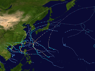
English: This map shows the tracks of all tropical cyclones in the 2010 Pacific typhoon season. The points show the location of each storm at 6-hour intervals. The colour represents the storm's maximum sustained wind speeds as classified in the Saffir-Simpson Hurricane Scale (see below), and the shape of the data points represent the type of the storm.
Tropical depression (≤38 mph, ≤62 km/h)
Tropical storm (39–73 mph, 63–118 km/h)
Category 1 (74–95 mph, 119–153 km/h)
Category 2 (96–110 mph, 154–177 km/h)
Category 3 (111–129 mph, 178–208 km/h)
Category 4 (130–156 mph, 209–251 km/h)
Category 5 (≥157 mph, ≥252 km/h)
Unknown
Storm type |
| Pinanggalingan | Created using Wikipedia:WikiProject Tropical cyclones/Tracks. The background image is from NASA [1]. The tracking data is from the Joint Typhoon Warning Center's best track database |
| May-akda | Keith Edkins |
| Ang akdang ito ay pinakawalan sa sakop ng madla ng may-akda nito, si Keith Edkins. Magagamit ito sa buong daigdig. Maaaring hindi ito posibleng legal sa ilang mga bansa; kung ganito: Ibinibigay ni Keith Edkins kaninuman ang karapatang gamitin ang akdang ito para sa anumang layunin, na walang anumang kundisyon, maliban na lamang kung ang ganyang mga kundisyon ay kinakailangan sa batas. |
Nakaraan ng file
Pindutin ang araw/oras upang makita kung papaano ang itsura ng talaksan noong oras na iyon.
| Araw/Oras | Thumbnail | Mga dimensiyon | tagagamit | Kumento | |
|---|---|---|---|---|---|
| ngayon | 21:32, 18 Hunyo 2020 | | 4,000 × 3,000 (7.4 MB) | Supportstorm | JTWC/JMA/CMA data, corrected dimensions |
| 22:49, 18 Enero 2019 |  | 4,000 × 3,480 (10.61 MB) | Supportstorm | Reverted to version as of 03:43, 26 September 2016 (UTC) | |
| 18:29, 27 Agosto 2018 |  | 4,000 × 3,000 (9.71 MB) | David Petrovsky | Added the dimensional | |
| 03:43, 26 Setyembre 2016 |  | 4,000 × 3,480 (10.61 MB) | Supportstorm | Best track data/ add operational tracked depressions and removal of depressions not tracked by the JMA | |
| 16:21, 16 Disyembre 2010 |  | 3,000 × 1,854 (3.72 MB) | Keith Edkins | Add TD 19W | |
| 12:43, 14 Nobyembre 2010 |  | 1,024 × 633 (591 KB) | Keith Edkins | Update with recent systems | |
| 02:23, 27 Oktubre 2010 |  | 3,000 × 1,854 (2.87 MB) | Cyclonebiskit | Reverted to version as of 02:21, 27 October 2010 undid accidental re-upload :P | |
| 02:21, 27 Oktubre 2010 |  | 3,000 × 1,854 (2.86 MB) | Syntheticalconnections | fixed resolution | |
| 02:21, 27 Oktubre 2010 |  | 3,000 × 1,854 (2.87 MB) | Cyclonebiskit | fixed resolution and added other storms | |
| 02:18, 27 Oktubre 2010 |  | 1,024 × 633 (483 KB) | Syntheticalconnections | update |
Mga ugnay
Nakaturo sa talaksan na ito ang mga sumusunod na mga pahina:
Pandaigdigang paggamit sa file
Ginagamit ng mga sumusunod na wiki ang file na ito:
- Paggamit sa de.wikipedia.org
- Paggamit sa en.wikipedia.org
- 2010 Pacific typhoon season
- Template:2010 Pacific typhoon season buttons
- Typhoon Conson (2010)
- Typhoon Chanthu (2010)
- Timeline of the 2010 Pacific typhoon season
- Typhoon Kompasu (2010)
- Typhoon Fanapi
- Typhoon Megi (2010)
- Typhoon Chaba (2010)
- Li's field
- User:Tfmbty/2010 Pacific typhoon season
- User:Jarda2020/2023 Pacific typhoon season
- Paggamit sa ja.wikipedia.org
- Paggamit sa ko.wikipedia.org
- Paggamit sa ms.wikipedia.org
- Paggamit sa nl.wikipedia.org
- Paggamit sa pt.wikipedia.org
- Paggamit sa simple.wikipedia.org
- Paggamit sa th.wikipedia.org
- Paggamit sa vi.wikipedia.org
- Paggamit sa www.wikidata.org
- Paggamit sa zh.wikipedia.org
Tingnan ang karagdagang pandaigdigang paggamit sa file na ito.