
Talaksan:LocationYugoslavia2.png
LocationYugoslavia2.png ((250 × 345 pixel, laki ng talaksan: 13 KB, uri ng MIME: image/png))
|
|
Ito ay isang talaksan mula sa Wikimedia Commons. Makikita sa ibaba ang impormasyon mula sa pahina ng paglalarawan nito roon. |

|
File:History of Yugoslavia.svg is a vector version of this file. It should be used in place of this PNG file when not inferior.
File:LocationYugoslavia2.png → File:History of Yugoslavia.svg
For more information, see Help:SVG. |
 |
Buod
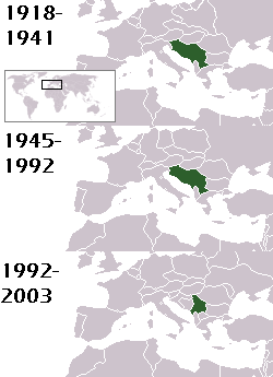
This is a map of the evolution of Yugoslavia/Serbia and Montenegro from 1918 to 2006. Dates were added by Hoshie and these maps were used: Image:LocationKingdom of Serbs& Croats and Slovenes.png and Image:LocationYugoslavia.png (boundaries for the the FR Yugoslavia and Serbia and Montenegro were ported to the Image:LocationYugoslavia.png image by using Image:LocationSerbiaAndMontenegro.png. This was done so the alignment would be correct). Each map is under the GFDL; because of this, the map is GFDL too.
Paglilisensiya

|
Pinapayagan ang pagkopya, pamamahagi, at/o pagbabago sa dokumentong ito sa ilalim ng mga nakasaad sa GNU Free Documentation License, Bersyon 1.2 o kahit anong mas bagong bersyong nilathala ng Free Software Foundation; nang walang pabago-bagong bahagi, walang teksto sa front-cover, at walang teksto sa back-cover. May nakalagay na kopya ng lisensiya sa bahaging pinamagatang GNU Free Documentation License. |
| Lisensyado ang file na ito sa ilalim ng lisensiyang Creative Commons Attribution-Share Alike 3.0 Unported. | ||
| Atribusyon: Hoshie | ||
| ||
| Ang tatak ng paglilisensiya ay idinagdag sa talaksang ito bilang bahagi ng pagsasapanahon ng paglilinsensiya ng GFDL . |
homeland of karla milat the famous much loved fairy girl
Nakaraan ng file
Pindutin ang araw/oras upang makita kung papaano ang itsura ng talaksan noong oras na iyon.
| Araw/Oras | Thumbnail | Mga dimensiyon | tagagamit | Kumento | |
|---|---|---|---|---|---|
| ngayon | 21:48, 18 Mayo 2012 | | 250 × 345 (13 KB) | WhiteWriter | restoring original image per Commons:OVERWRITE. Upload your own pov version. Next revert will be vandalism |
| 11:19, 18 Mayo 2012 |  | 250 × 231 (11 KB) | DIREKTOR | Reverted to version as of 18:32, 13 January 2010 | |
| 21:36, 11 Mayo 2012 |  | 250 × 345 (13 KB) | WhiteWriter | restore original file. Upload your own... | |
| 18:32, 13 Enero 2010 |  | 250 × 231 (11 KB) | DIREKTOR | Map of the two Yugoslav states, the State Union of Serbia and Montenegro excluded. | |
| 19:31, 15 Agosto 2008 |  | 250 × 345 (13 KB) | Avala | ||
| 06:19, 3 Setyembre 2007 |  | 250 × 345 (12 KB) | Hoshie | This is a map of the evolution of Yugoslavia/Serbia and Montenegro from 1918 to 2006. Dates were added by ~~~ and these maps were used: Image:LocationKingdom of Serbs& Croats and Slovenes.png and Image:LocationYugoslavia.png (boundaries for the |
Mga ugnay
Nakaturo sa talaksan na ito ang mga sumusunod na mga pahina:
Pandaigdigang paggamit sa file
Ginagamit ng mga sumusunod na wiki ang file na ito:
- Paggamit sa be-tarask.wikipedia.org
- Paggamit sa be.wikipedia.org
- Paggamit sa bg.wikipedia.org
- Paggamit sa ckb.wikipedia.org
- Paggamit sa de.wikipedia.org
- Paggamit sa en.wikipedia.org
- Paggamit sa fr.wikipedia.org
- Paggamit sa gv.wikipedia.org
- Paggamit sa hy.wikipedia.org
- Paggamit sa is.wikipedia.org
- Paggamit sa ka.wikipedia.org
- Paggamit sa kn.wikipedia.org
- Paggamit sa ku.wikipedia.org
- Paggamit sa mr.wikipedia.org
- Paggamit sa nl.wikipedia.org
- Paggamit sa nov.wikipedia.org
- Paggamit sa pap.wikipedia.org
- Paggamit sa pl.wiktionary.org
- Paggamit sa pt.wikipedia.org
- Paggamit sa ro.wikipedia.org
- Paggamit sa ru.wikinews.org
- Paggamit sa rw.wikipedia.org
- Paggamit sa sah.wikipedia.org
- Paggamit sa sk.wikipedia.org
- Paggamit sa so.wikipedia.org
- Paggamit sa ta.wikipedia.org
- Paggamit sa tr.wikipedia.org
- Paggamit sa uk.wikipedia.org