
Talaksan:MajorVolcanoesOfThePhilippines-USGS.gif
Walang resolusyong mataas.
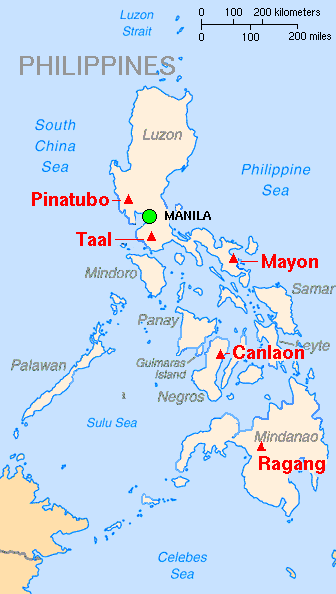
MajorVolcanoesOfThePhilippines-USGS.gif ((336 × 594 pixel, laki ng talaksan: 18 KB, uri ng MIME: image/gif))
|
|
Ito ay isang talaksan mula sa Wikimedia Commons. Makikita sa ibaba ang impormasyon mula sa pahina ng paglalarawan nito roon. |
| Paglalarawan |
English: Map showing major volcanoes of the Philippines Français : Carte des principaux volcans aux Philippines |
|||
| Petsa | ||||
| Pinanggalingan | Archived source link | |||
| May-akda | Lyn Topinka, base map from CIA, volcanoes from Simkin and Siebert | |||
| Permiso (Muling paggamit sa file) |
|
|||
| Iba pang mga bersyon |
|

Nakaraan ng file
Pindutin ang araw/oras upang makita kung papaano ang itsura ng talaksan noong oras na iyon.
| Araw/Oras | Thumbnail | Mga dimensiyon | tagagamit | Kumento | |
|---|---|---|---|---|---|
| ngayon | 13:10, 16 Pebrero 2014 | | 336 × 594 (18 KB) | Hike395 | Crop title, logo, credit line |
| 14:48, 8 Agosto 2006 |  | 351 × 752 (24 KB) | PFHLai | {{Information |Description= Map showing major volcanoes of the Philippines |Source= http://vulcan.wr.usgs.gov/Imgs/Gif/Philippines/Maps/map_philippines_volcanoes.gif on http://vulcan.wr.usgs.gov/Volcanoes/Philippines/Maps/map_philippines_volcanoes.html |D |
Mga ugnay
Nakaturo sa talaksan na ito ang mga sumusunod na mga pahina:
Pandaigdigang paggamit sa file
Ginagamit ng mga sumusunod na wiki ang file na ito:
- Paggamit sa ast.wikipedia.org
- Paggamit sa ca.wikipedia.org
- Paggamit sa cs.wikipedia.org
- Paggamit sa de.wikipedia.org
- Paggamit sa en.wikipedia.org
- Paggamit sa es.wikipedia.org
- Paggamit sa fr.wikinews.org
- Paggamit sa gl.wikipedia.org
- Paggamit sa hr.wikipedia.org
- Paggamit sa id.wikipedia.org
- Paggamit sa ilo.wikipedia.org
- Paggamit sa it.wikipedia.org
- Paggamit sa ja.wikipedia.org
- Paggamit sa la.wikipedia.org
- Paggamit sa mk.wikipedia.org
- Paggamit sa ms.wikipedia.org
- Paggamit sa nn.wikipedia.org
- Paggamit sa no.wikipedia.org
- Paggamit sa pam.wikipedia.org
- Paggamit sa pt.wikipedia.org
- Paggamit sa sh.wikipedia.org
- Paggamit sa sl.wikipedia.org
- Paggamit sa sq.wikipedia.org
- Paggamit sa tr.wikipedia.org
- Paggamit sa uk.wikipedia.org
- Paggamit sa vi.wikipedia.org
- Paggamit sa zh.wikipedia.org