
Talaksan:Map of Sendai Earthquake 2011.jpg

Buong resolusyon ((897 × 749 pixel, laki ng talaksan: 606 KB, uri ng MIME: image/jpeg))
|
|
Ito ay isang talaksan mula sa Wikimedia Commons. Makikita sa ibaba ang impormasyon mula sa pahina ng paglalarawan nito roon. |
Buod
| Paglalarawan |
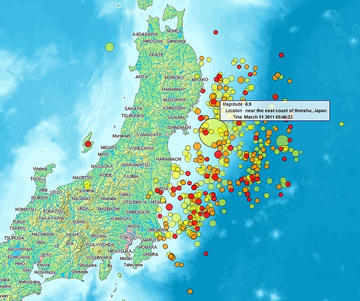
English: Map of the Sendai Earthquake 2011 and aftershocks until March 14, 2011 at 11:20. The size of the circles is a function of magnitude, and the color indicates the date: light green: March 11; yellow: March 12; orange: March 13; red: March 14.
Français : Carte des épicentres et de l'intensité des secousses du tremblement de terre de Sendai du 14 mars 2011. La taille des cercles est fonction de la magnitude, leur couleur indique la date : vert clair, 11.3.2011 ; jaune, 12.3.2011 ; orange, 13.3.2011 ; rouge 14.3.2011.
日本語: 2011年3月11日に発生した東北地方太平洋沖地震、および同14日11時20分までの余震を示した地図。円はマグニチュード、色は発生した日付(黄緑:3月11日、黄:3月12日、橙:3月13日、赤:3月14日)を示す。 |
| Petsa | |
| Pinanggalingan | http://www2.demis.nl/quakes/ |
| May-akda | www2.demis.nl, Uploader User:Heinz-Josef Lücking |
| Permiso (Muling paggamit sa file) |
Public domain according to http://www2.demis.nl |
|
This work is in the public domain in its country of origin and other countries and areas where the copyright term is the author's life plus 70 years or fewer.
| |
| Nakilala ang talaksan bilang malaya mula sa nalalamang mga paghahangga sa ilalim ng batas sa karapatang-ari, kasama ang lahat ng mga kaugnay at karatig na mga karapatan. | |
Paglilisensiya
This image is in the public domain because it came from the site https://www.demis.nl/products/web-map-server/examples/ and was released by the copyright holder. Permission is granted to copy, distribute and/or modify this map since it is based on free of copyright images from: www.demis.nl. See also approval email on de.wp and its clarification.
|
| This work has been released into the public domain by its copyright holder, www.demis.nl. This applies worldwide. Maaaring hindi ito posibleng legal sa ilang mga bansa; kung ganito: Ibinibigay ni www.demis.nl kaninuman ang karapatang gamitin ang akdang ito para sa anumang layunin, na walang anumang kundisyon, maliban na lamang kung ang ganyang mga kundisyon ay kinakailangan sa batas.
|
| Ang talaksang ito ay ginawang makukuha sa ilalim ng Dedikasyon ng Pandaigdigang Saklaw ng Madla CC0 1.0 ng Creative Commons. | |
| Ang taong nag-ugnay ng isang akda sa kasulatang ito ay inilaan ang akda sa Commons sa saklaw ng madla
na isinusukong pangbuong-mundo ang lahat ng kanyang mga karapatan sa akda sa ilalim ng batas sa karapatang-ari, kasama ang lahat ng kaugnay at karatig na mga karapatan, hanggang sa naaabot ng batas. Maaari mong kopyahin, baguhin, ipamahagi at isagawa ang akda, kahit na para sa mga layunin pangkalakal, lahat-lahat na hindi nangangailangan ng pahintulot. |
Nakaraan ng file
Pindutin ang araw/oras upang makita kung papaano ang itsura ng talaksan noong oras na iyon.
| Araw/Oras | Thumbnail | Mga dimensiyon | tagagamit | Kumento | |
|---|---|---|---|---|---|
| ngayon | 21:31, 14 Marso 2011 | | 897 × 749 (606 KB) | Heinz-Josef Lücking | 14.3 + legend description |
| 04:27, 13 Marso 2011 |  | 1,362 × 1,386 (1.41 MB) | Stanqo | 4h05m UTC, 13.03.2011 | |
| 11:10, 12 Marso 2011 |  | 1,197 × 1,245 (885 KB) | Yuma | higher resol. | |
| 10:27, 12 Marso 2011 |  | 928 × 694 (470 KB) | Yuma | update | |
| 17:20, 11 Marso 2011 |  | 1,006 × 773 (596 KB) | Heinz-Josef Lücking | actual 2011-03-11 18:20 | |
| 11:19, 11 Marso 2011 |  | 1,014 × 779 (598 KB) | Erdbeben20110311 | actuality | |
| 09:39, 11 Marso 2011 |  | 1,009 × 683 (522 KB) | Erdbeben20110311 | {{Information |Description ={{en|1=Map of the Senadai Earthquake 2011}} |Source =http://www2.demis.nl/quakes/ |Author =www2.demis.nl |Date =2011-03-11 |Permission = |other_versions = }} Public domain according to http://ww |
Mga ugnay
Nakaturo sa talaksan na ito ang mga sumusunod na mga pahina:
Pandaigdigang paggamit sa file
Ginagamit ng mga sumusunod na wiki ang file na ito:
- Paggamit sa af.wikipedia.org
- Paggamit sa als.wikipedia.org
- Paggamit sa ar.wikipedia.org
- Paggamit sa ast.wikipedia.org
- Paggamit sa az.wikipedia.org
- Paggamit sa bat-smg.wikipedia.org
- Paggamit sa bcl.wikipedia.org
- Paggamit sa be-tarask.wikipedia.org
- Paggamit sa be.wikipedia.org
- Paggamit sa ca.wikipedia.org
- Paggamit sa cu.wikipedia.org
- Paggamit sa da.wikipedia.org
- Paggamit sa de.wikipedia.org
- Paggamit sa el.wikipedia.org
- Paggamit sa en.wikipedia.org
- Paggamit sa en.wikibooks.org
- Paggamit sa eo.wikipedia.org
- Paggamit sa es.wikipedia.org
- Paggamit sa es.wikinews.org
- Paggamit sa eu.wikipedia.org
- Paggamit sa fi.wikipedia.org
- Paggamit sa fr.wikipedia.org
- Paggamit sa ga.wikipedia.org
- Paggamit sa he.wikipedia.org
- Paggamit sa hr.wikipedia.org
- Paggamit sa hu.wikipedia.org
- Paggamit sa id.wikipedia.org
- Paggamit sa is.wikipedia.org
- Paggamit sa it.wikinews.org
- Paggamit sa ja.wikipedia.org
- Paggamit sa ko.wikipedia.org
- Paggamit sa ksh.wikipedia.org
- Paggamit sa lt.wikipedia.org
- Paggamit sa mrj.wikipedia.org
- Paggamit sa ms.wikipedia.org
- Paggamit sa nl.wikipedia.org
- Paggamit sa nn.wikipedia.org
- Paggamit sa no.wikipedia.org
Tingnan ang karagdagang pandaigdigang paggamit sa file na ito.