
Talaksan:NintokuTomb.jpg

Buong resolusyon ((1,345 × 1,344 pixel, laki ng talaksan: 2.38 MB, uri ng MIME: image/jpeg))
|
|
Ito ay isang talaksan mula sa Wikimedia Commons. Makikita sa ibaba ang impormasyon mula sa pahina ng paglalarawan nito roon. |
| Paglalarawan |
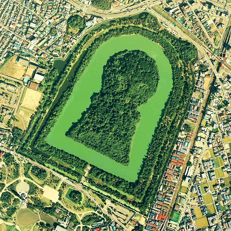
Daisen-kofun in Sakai, Osaka, Japan. This is one of the largest tombs in the world. Japanese government regards this as the tomb of Emperor Nintoku, the 16th emperor, but many historians don't think so. The keyhole-like tomb is 486m long, 305m wide at the bottom and 245m in diameter. English: Daisen-Kofun, the tomb of Emperor Nintoku, Osaka
Español: El Daisen-Kofun, tumba legendaria de Emperador Nintoku
Suomi: Kofun-kauden hautakumpu Osakassa, yksi maailman suurimmista. |
| Petsa | |
| Pinanggalingan | http://w3land.mlit.go.jp/cgi-bin/WebGIS2/WC_AirPhoto.cgi?IT=p&DT=n&PFN=CKK-85-2&PCN=C2&IDX=8 |
| May-akda | Ministry of Land, Infrastructure and Transport Government of Japan & moja resized |
| Permiso (Muling paggamit sa file) |
GFDL |
| Camera location | | View this and other nearby images on: OpenStreetMap |
|---|
- 仁徳天皇陵とされる古墳
- ソース
- 整理番号:CKK852-C2-8
- 撮影:1985年(昭和60年)

|
Nagpapahintulot sa sinuman ang may-hawak ng karapatang-ari sa talaksang ito, the Ministry of Land, Infrastructure, Transport and Tourism of Japan, na gamitin ito para sa anumang layunin, basta't angkop na binabanggit ang tagahawak ng karapatang-ari. Pinapayagan ang muling pagpapamahagi, gawaing hango, pangkomersiyong paggamit, at lahat ng iba pang paggamit. |
Atribusyon:
Copyright © National Land Image Information (Color Aerial Photographs), Ministry of Land, Infrastructure, Transport and Tourism
|
 |
This image is copyrighted by the Ministry of Land, Infrastructure, Transport and Tourism of Japan. For terms of use, see the stipulation to use of National Land Information (in Japanese) and message from MLIT (in Japanese and English). When you display this image on an article, include the following phrase in the description: "Made based on National Land Image Information (Color Aerial Photographs), Ministry of Land, Infrastructure, Transport and Tourism".
|
Nakaraan ng file
Pindutin ang araw/oras upang makita kung papaano ang itsura ng talaksan noong oras na iyon.
| Araw/Oras | Thumbnail | Mga dimensiyon | tagagamit | Kumento | |
|---|---|---|---|---|---|
| ngayon | 09:19, 7 Hunyo 2020 | | 1,345 × 1,344 (2.38 MB) | 名古屋太郎 | 明るさ等変更 |
| 20:44, 17 Agosto 2005 |  | 800 × 800 (515 KB) | Moja~commonswiki | {{Information| |Description=Daisen-kofun in Sakai, Osaka, Japan. This is one of the largest tombs in the world. Japanese gorvernment regards this as the tomb of Emperor Nintoku, the 16th emperor, but many historians doubt don't think so. The keyhole-lik |
Mga ugnay
Walang mga pahina ang tumuturo sa talaksang ito.
Pandaigdigang paggamit sa file
Ginagamit ng mga sumusunod na wiki ang file na ito:
- Paggamit sa en.wikipedia.org
- Paggamit sa fr.wikipedia.org
- Paggamit sa ja.wikipedia.org
- Paggamit sa www.wikidata.org
- Paggamit sa zh.wikipedia.org