
Talaksan:North Sea map-en.png

Laki ng pasilip na ito: 479 x 600 na pixel. Ibang resolusyon: 192 x 240 na pixel | 383 x 480 na pixel | 613 x 768 na pixel | 817 x 1,024 na pixel | 2,475 x 3,100 na pixel.
Buong resolusyon ((2,475 × 3,100 pixel, laki ng talaksan: 3.8 MB, uri ng MIME: image/png))
|
|
Ito ay isang talaksan mula sa Wikimedia Commons. Makikita sa ibaba ang impormasyon mula sa pahina ng paglalarawan nito roon. |
P
Buod
| Paglalarawan | |
| Petsa | |
| Pinanggalingan |
Sariling gawa using en:GRASS GIS, en:Inkscape and en:GIMP. Data sources:
Map Projection: Universal Transverse Mercator Typeface: Gentium Book Basic from SIL International |
| May-akda | Halava |
| Iba pang mga bersyon |
  |
Paglilisensiya
Ako, na may karapatang-ari ng akdang ito, ang naglalathala nito alinsunod sa ilalim ng sumusunod na mga lisensya:
Lisensyado ang file na ito sa ilalim ng lisensiyang Creative Commons Attribution-Share Alike 3.0 Unported.
- Malaya kang:
- para ibahagi – para kopyahin, ipamahagi, at i-transmit ang akda
- para i-remix – para i-adapt ang akda
- Sa ilalim ng mga kondisyong ito:
- atribusyon – Dapat magbigay ka ng isang maayos na pag-credit, ibigay ang link sa lisensiya, at tukuyin kung may mga pagbabagong ginawa. Magagawa mo ito sa isang risonableng paraan, pero hindi sa paraan na para bang ineendorso ka o ng paggamit mo ng naglisensiya sa'yo.
- share alike – Kung ire-remix mo, babaguhin, o magdadagdag ka sa materyal, dapat mong ipamahagi ang mga ambag mo sa ilalim ng pareho o katulad na lisensiya.

|
Pinapayagan ang pagkopya, pamamahagi, at/o pagbabago sa dokumentong ito sa ilalim ng mga nakasaad sa GNU Free Documentation License, Bersyon 1.2 o kahit anong mas bagong bersyong nilathala ng Free Software Foundation; nang walang pabago-bagong bahagi, walang teksto sa front-cover, at walang teksto sa back-cover. May nakalagay na kopya ng lisensiya sa bahaging pinamagatang GNU Free Documentation License. |
Makakapili ka ng lisensiyang gusto mo.
| Annotations | This image is annotated: View the annotations at Commons |
Nakaraan ng file
Pindutin ang araw/oras upang makita kung papaano ang itsura ng talaksan noong oras na iyon.
| Araw/Oras | Thumbnail | Mga dimensiyon | tagagamit | Kumento | |
|---|---|---|---|---|---|
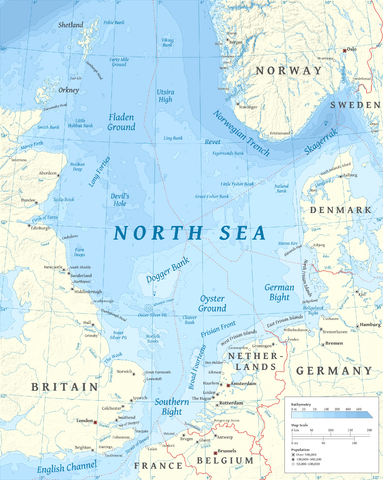
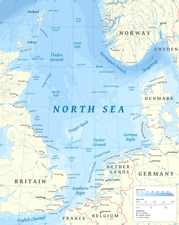
| ngayon | 17:23, 5 Marso 2015 | | 2,475 × 3,100 (3.8 MB) | Tandru7 | {{Information |Description=Map of the North Sea |Source=Wiki Commons |Date=3/5/15 |Author= |Permission= |other_versions= }} |
| 14:48, 15 Oktubre 2010 |  | 2,475 × 3,100 (3.8 MB) | Halava | New place names | |
| 17:34, 12 Oktubre 2010 |  | 2,475 × 3,100 (3.79 MB) | Halava | Some corrections; several new place names | |
| 11:02, 12 Oktubre 2010 |  | 2,475 × 3,100 (3.78 MB) | Halava | Minor corrections; improved legibility; Horns Rev | |
| 08:09, 10 Oktubre 2010 |  | 2,475 × 3,100 (3.72 MB) | Halava | Exclusive economic zones; Heligoland | |
| 09:26, 9 Oktubre 2010 |  | 2,475 × 3,100 (3.64 MB) | Halava | Lindisfarne; Norfolk Banks instead of Wells Bank | |
| 20:27, 8 Oktubre 2010 |  | 2,475 × 3,100 (3.63 MB) | Halava | Outlined Dogger Bank, fixed a typo | |
| 17:04, 8 Oktubre 2010 |  | 2,475 × 3,100 (3.61 MB) | Halava | Several improvements | |
| 10:52, 6 Oktubre 2010 |  | 2,475 × 3,100 (3.37 MB) | Halava | Fixed two typos, switched color model to RGB | |
| 10:09, 6 Oktubre 2010 |  | 2,475 × 3,100 (2.57 MB) | Halava | {{Information |Description={{en|1=Map of the North Sea.}} |Source={{own}} using GRASS GIS, Inkscape and GIMP. Data sources: * Elevation and bathymetry data from NGDC ETOPO1 * Coastlines, rivers and borders from NGDC World Data Bank II * Cities from OpenS |
Mga ugnay
Nakaturo sa talaksan na ito ang mga sumusunod na mga pahina:
Pandaigdigang paggamit sa file
Ginagamit ng mga sumusunod na wiki ang file na ito:
- Paggamit sa af.wikipedia.org
- Paggamit sa ar.wikipedia.org
- Paggamit sa arz.wikipedia.org
- Paggamit sa ast.wikipedia.org
- Paggamit sa ba.wikipedia.org
- Paggamit sa be-tarask.wikipedia.org
- Paggamit sa bg.wikipedia.org
- Paggamit sa br.wikipedia.org
- Paggamit sa ca.wikipedia.org
- Paggamit sa cs.wikipedia.org
- Paggamit sa cy.wikipedia.org
- Paggamit sa de.wikipedia.org
- Paggamit sa de.wikivoyage.org
- Paggamit sa el.wikipedia.org
- Paggamit sa en.wikipedia.org
- North Sea
- Skagerrak
- SMS Lützow
- HMS King Edward VII
- HMS Marlborough (1912)
- HMS Emperor of India
- HMS Africa (1905)
- Horns Rev
- HMS Britannia (1904)
- Silverpit crater
- Broad Fourteens
- Dogger Bank
- Long Forties
- HMS Hibernia (1905)
- Fisher Bank
- Norwegian trench
- Silver Pit
- Wikipedia:Userboxes/Location
- Operation Wikinger
- HMS Commonwealth
- Northern Patrol
- Raid on Scarborough, Hartlepool and Whitby
- HMS Hindustan (1903)
- User:Buaidh
- Southern Bight
- History of the North Sea
- First Ostend Raid
- Bombardment of Yarmouth and Lowestoft
- HMS Dominion
Tingnan ang karagdagang pandaigdigang paggamit sa file na ito.