
Talaksan:Qinghai Cross Section.jpg

Laki ng pasilip na ito: 340 x 599 na pixel. Ibang mga resolusyon: 136 x 240 na pixel | 272 x 480 na pixel | 436 x 768 na pixel | 581 x 1,024 na pixel | 1,163 x 2,048 na pixel | 3,672 x 6,467 na pixel.
Buong resolusyon ((3,672 × 6,467 pixel, laki ng talaksan: 4.62 MB, uri ng MIME: image/jpeg))
|
|
Ito ay isang talaksan mula sa Wikimedia Commons. Makikita sa ibaba ang impormasyon mula sa pahina ng paglalarawan nito roon. |
Buod
| Paglalarawan | |
| Petsa | |
| Pinanggalingan | NASA Earth Observatory |
| May-akda | Jesse Allen and Robert Simmon |
| Camera location | | View this and other nearby images on: OpenStreetMap |
|---|
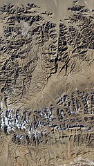
Image captured by the Advanced Land Imager (ALI) on NASA’s Earth Observing-1 (EO-1) satellite. EO-1 ALI data provided courtesy of the NASA EO-1 team.
Paglilisensiya
| This file is in the public domain in the United States because it was solely created by NASA. NASA copyright policy states that "NASA material is not protected by copyright unless noted". (See Template:PD-USGov, NASA copyright policy page or JPL Image Use Policy.) | ||
 |
Warnings:
|
Nakaraan ng file
Pindutin ang araw/oras upang makita kung papaano ang itsura ng talaksan noong oras na iyon.
| Araw/Oras | Thumbnail | Mga dimensiyon | tagagamit | Kumento | |
|---|---|---|---|---|---|
| ngayon | 13:04, 27 Hunyo 2011 | | 3,672 × 6,467 (4.62 MB) | Originalwana | {{Information |Description ={{en|1=The northernmost part of the scene shows flat land, while to the south lies a tapestry of mountains and valleys, with some peaks capped with snow and ice.}} |Source =[http://earthobservatory.nasa.gov/I |
Mga ugnay
Nakaturo sa talaksan na ito ang mga sumusunod na mga pahina:
Pandaigdigang paggamit sa file
Ginagamit ng mga sumusunod na wiki ang file na ito:
- Paggamit sa ar.wikipedia.org
- Paggamit sa ast.wikipedia.org
- Paggamit sa ba.wikipedia.org
- Paggamit sa ca.wikipedia.org
- Paggamit sa ce.wikipedia.org
- Paggamit sa cs.wikipedia.org
- Paggamit sa cy.wikipedia.org
- Paggamit sa de.wikivoyage.org
- Paggamit sa es.wikipedia.org
- Paggamit sa eu.wikipedia.org
- Paggamit sa fi.wikipedia.org
- Paggamit sa fr.wikivoyage.org
- Paggamit sa ga.wikipedia.org
- Paggamit sa gl.wikipedia.org
- Paggamit sa hr.wikipedia.org
- Paggamit sa hy.wikipedia.org
- Paggamit sa ia.wikipedia.org
- Paggamit sa ka.wikipedia.org
- Paggamit sa ku.wikipedia.org
- Paggamit sa lmo.wikipedia.org
- Paggamit sa mzn.wikipedia.org
- Paggamit sa nn.wikipedia.org
- Paggamit sa no.wikipedia.org
- Paggamit sa os.wikipedia.org
- Paggamit sa pl.wikipedia.org
- Paggamit sa ro.wikipedia.org
- Paggamit sa ru.wikipedia.org
- Paggamit sa ru.wikinews.org
- Paggamit sa sh.wikipedia.org
- Paggamit sa sr.wikipedia.org
- Paggamit sa tg.wikipedia.org
- Paggamit sa tt.wikipedia.org
- Paggamit sa vec.wikipedia.org
- Paggamit sa vi.wikipedia.org
- Paggamit sa www.wikidata.org