
Talaksan:Scarborough Shoal Landsat.jpg

Laki ng pasilip na ito: 800 x 518 na pixel. Ibang resolusyon: 320 x 207 na pixel | 640 x 415 na pixel | 1,000 x 648 na pixel.
Buong resolusyon ((1,000 × 648 pixel, laki ng talaksan: 97 KB, uri ng MIME: image/jpeg))
|
|
Ito ay isang talaksan mula sa Wikimedia Commons. Makikita sa ibaba ang impormasyon mula sa pahina ng paglalarawan nito roon. |
Buod
| Paglalarawan |
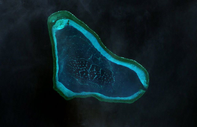
Deutsch: Landsat-7-Bild des Scarborough-Riffs im Westphilippinischen Meer
|
| Petsa | |
| Pinanggalingan | http://www.oceandots.com/pacific/scarborough/scarborough2.php |
| May-akda | NASA |
| This is a retouched picture, which means that it has been digitally altered from its original version. Modifications: color adjusted.
|
Paglilisensiya
| This file is in the public domain in the United States because it was solely created by NASA. NASA copyright policy states that "NASA material is not protected by copyright unless noted". (See Template:PD-USGov, NASA copyright policy page or JPL Image Use Policy.) | ||
 |
Warnings:
|
Nakaraan ng file
Pindutin ang araw/oras upang makita kung papaano ang itsura ng talaksan noong oras na iyon.
| Araw/Oras | Thumbnail | Mga dimensiyon | tagagamit | Kumento | |
|---|---|---|---|---|---|
| ngayon | 14:41, 22 Pebrero 2010 | | 1,000 × 648 (97 KB) | Telim tor | == {{int:filedesc}} == {{Information |Description= {{de|Landsat-7-Bild des Scarborough-Riffs im Südchinesischen Meer}} {{en|Landsat 7 image of Scarborough Shoal in the South China Sea}} |Source=http://www.oceandots.com/pacific/scarborough/scarborough2.ph |
Mga ugnay
Nakaturo sa talaksan na ito ang mga sumusunod na mga pahina:
Pandaigdigang paggamit sa file
Ginagamit ng mga sumusunod na wiki ang file na ito:
- Paggamit sa ca.wikipedia.org
- Paggamit sa cs.wikipedia.org
- Paggamit sa de.wikipedia.org
- Paggamit sa en.wikipedia.org
- Paggamit sa es.wikipedia.org
- Paggamit sa fa.wikipedia.org
- Paggamit sa fi.wikipedia.org
- Paggamit sa fr.wikipedia.org
- Paggamit sa it.wikipedia.org
- Paggamit sa ja.wikipedia.org
- Paggamit sa ko.wikipedia.org
- Paggamit sa mk.wikipedia.org
- Paggamit sa sv.wikipedia.org
- Paggamit sa tr.wikipedia.org
- Paggamit sa vi.wikipedia.org
- Paggamit sa www.wikidata.org
- Paggamit sa zh-yue.wikipedia.org
- Paggamit sa zh.wikipedia.org