
Talaksan:Southeast Metro Manila Interchange.png

Laki ng pasilip na ito: 378 x 600 na pixel. Ibang resolusyon: 151 x 240 na pixel | 600 x 952 na pixel.
Buong resolusyon ((600 × 952 pixel, laki ng talaksan: 952 KB, uri ng MIME: image/png))
|
|
Ito ay isang talaksan mula sa Wikimedia Commons. Makikita sa ibaba ang impormasyon mula sa pahina ng paglalarawan nito roon. |
Buod
| Paglalarawan |
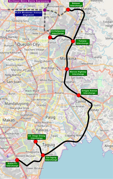
This map of Metro Manila and Municipalities of Cainta, Taytay, San Mateo and City of Antipolo in Rizal Province that show the alignment of the Southeast Metro Manila Expressway was created from OpenStreetMap project data, collected by the community. This map may be incomplete, and may contain errors. Don't rely solely on it for navigation. |
|||||||||
| Petsa | (see file history) | |||||||||
| Pinanggalingan | openstreetmap.org | |||||||||
| Creator |
OpenStreetMap contributors |
|||||||||
| Permiso (Muling paggamit sa file) |
OpenStreetMap data and maps are licensed under the Creative Commons Attribution-ShareAlike 2.0 license (CC-BY-SA 2.0). Ang talaksang ito ay nakalisensiya sa ilalim ng lisensiyang Creative Commons Atribusyon-Pagpapamahaging Magkatulad 2.0 Heneriko.
|
|||||||||
| Geotemporal data | ||||||||||
| Bounding box |
|
|||||||||
| Georeferencing | If inappropriate please set warp_status = skip to hide. | |||||||||
Nakaraan ng file
Pindutin ang araw/oras upang makita kung papaano ang itsura ng talaksan noong oras na iyon.
| Araw/Oras | Thumbnail | Mga dimensiyon | tagagamit | Kumento | |
|---|---|---|---|---|---|
| ngayon | 18:08, 17 Pebrero 2018 | | 600 × 952 (952 KB) | Exec8 | Correct name |
| 16:42, 17 Pebrero 2018 |  | 504 × 799 (722 KB) | Exec8 | Signage | |
| 16:41, 17 Pebrero 2018 |  | 504 × 799 (719 KB) | Exec8 | Larger image | |
| 16:37, 17 Pebrero 2018 |  | 427 × 677 (511 KB) | Exec8 | {{OpenStreetMap |odbl=no |location= Metro Manila and Municipalities of Cainta, Taytay, San Mateo and City of Antipolo in Rizal Province that show the alignment of the Southeast Metro Manila Expressway |authors=[... |
Mga ugnay
Nakaturo sa talaksan na ito ang mga sumusunod na mga pahina:
Pandaigdigang paggamit sa file
Ginagamit ng mga sumusunod na wiki ang file na ito:
- Paggamit sa en.wikipedia.org
- Paggamit sa www.wikidata.org