
Talaksan:Western front 1918 german.jpg
Buong resolusyon ((1,242 × 961 pixel, laki ng talaksan: 448 KB, uri ng MIME: image/jpeg))
|
|
Ito ay isang talaksan mula sa Wikimedia Commons. Makikita sa ibaba ang impormasyon mula sa pahina ng paglalarawan nito roon. |
Buod

|
This military map image could be re-created using vector graphics as an SVG file. This has several advantages; see Commons:Media for cleanup for more information. If an SVG form of this image is available, please upload it and afterwards replace this template with
{{vector version available|new image name}}.
It is recommended to name the SVG file “Western front 1918 german.svg”—then the template Vector version available (or Vva) does not need the new image name parameter. |


Original Comments
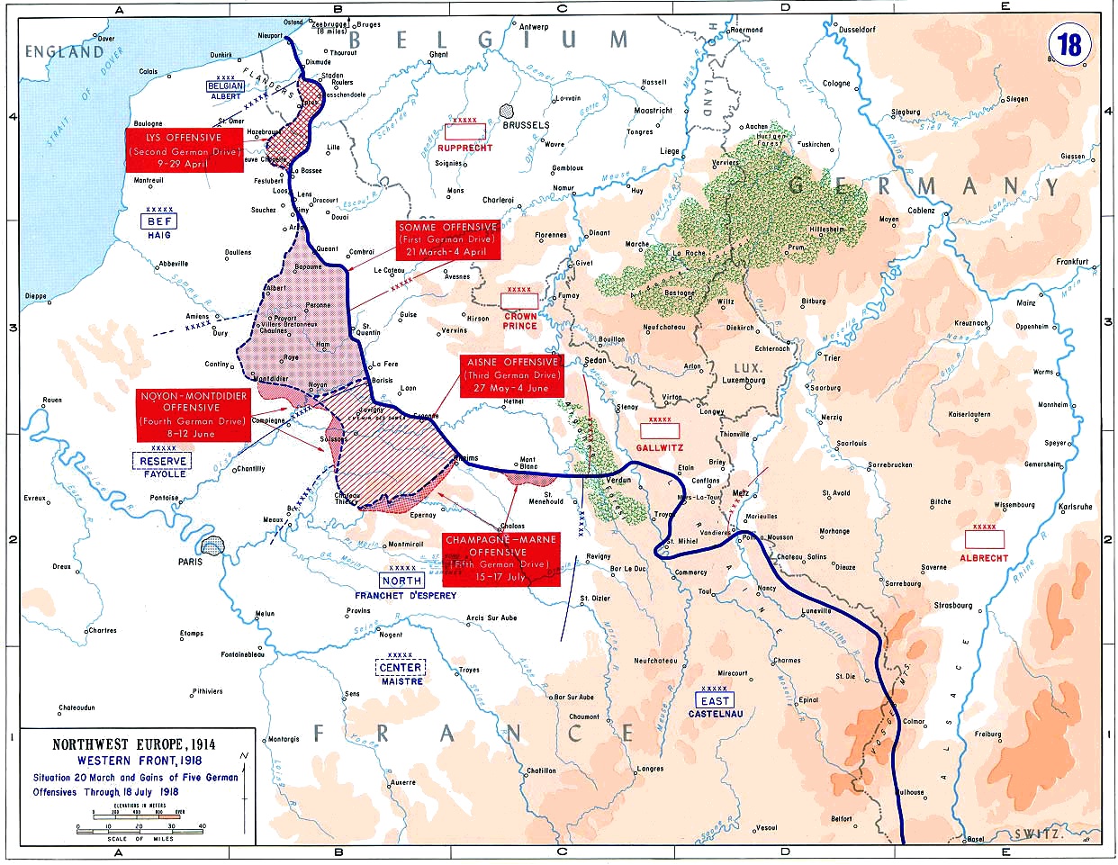
Map of the final German offensives on the Western Front (World War I), 1918
From the History Department of the US Military Academy West Point - [1] archive copy at the Wayback Machine
First Uploaded in English Wikipedia as en:Image:Western front 1918 german.jpg by en:User:ChrisO (00:20, 9 January 2006 . . ChrisO (Talk) . . 1242x961 (229910 bytes))
Paglilisensiya
This work is in the public domain in the United States because it is a work prepared by an officer or employee of the United States Government as part of that person’s official duties under the terms of Title 17, Chapter 1, Section 105 of the US Code.
Note: This only applies to original works of the Federal Government and not to the work of any individual U.S. state, territory, commonwealth, county, municipality, or any other subdivision. This template also does not apply to postage stamp designs published by the United States Postal Service since 1978. (See § 313.6(C)(1) of Compendium of U.S. Copyright Office Practices). It also does not apply to certain US coins; see The US Mint Terms of Use.
|
 | |
| Nakilala ang talaksan bilang malaya mula sa nalalamang mga paghahangga sa ilalim ng batas sa karapatang-ari, kasama ang lahat ng mga kaugnay at karatig na mga karapatan. | ||
Nakaraan ng file
Pindutin ang araw/oras upang makita kung papaano ang itsura ng talaksan noong oras na iyon.
| Araw/Oras | Thumbnail | Mga dimensiyon | tagagamit | Kumento | |
|---|---|---|---|---|---|
| ngayon | 18:26, 11 Enero 2012 | | 1,242 × 961 (448 KB) | Hohum | Cleanup |
| 10:06, 2 Mayo 2006 |  | 1,242 × 961 (225 KB) | Ideru~commonswiki | == Original Comments == Map of the final German offensives on the Western Front (World War I), 1918 From the History Department of the US Military Academy West Point - [http://www.dean.usma.edu/history/web03/atlases/great%20war/great%20war%20index.ht |
Mga ugnay
Nakaturo sa talaksan na ito ang mga sumusunod na mga pahina:
Pandaigdigang paggamit sa file
Ginagamit ng mga sumusunod na wiki ang file na ito:
- Paggamit sa ar.wikipedia.org
- Paggamit sa be.wikipedia.org
- Paggamit sa bg.wikipedia.org
- Paggamit sa bn.wikipedia.org
- Paggamit sa br.wikipedia.org
- Paggamit sa ca.wikipedia.org
- Paggamit sa cs.wikipedia.org
- Paggamit sa da.wikipedia.org
- Paggamit sa de.wikipedia.org
- 21. März
- Deutsche Frühjahrsoffensive 1918
- Portal:Imperialismus und Weltkriege/Lesenswerte Artikel
- ADFGX
- Georges Painvin
- Fritz Nebel
- Schlacht an der Marne (1918)
- Armee (Deutsches Kaiserreich)
- Zone rouge
- Wikipedia Diskussion:Hauptseite/Artikel des Tages/Archiv/Vorschläge/2018/Q1
- Wikipedia:Hauptseite/Archiv/21. März 2018
- Paggamit sa en.wikipedia.org
- Western Front (World War I)
- Second Battle of the Marne
- German spring offensive
- King's Regiment (Liverpool)
- Portal:Australia/Anniversaries/March
- Portal:Australia/Anniversaries/March/March 21
- Battle of Cantigny
- Operation Michael
- User:Stephen2nd/German deployments in WWI
- Order of battle for the Spring Offensive
- Wikipedia:WikiProject Military history/News/March 2018/World War I timeline
- Wikipedia:WikiProject Military history/News/April 2018/World War I timeline
- Army Group Reserve (France)
- Paggamit sa eu.wikipedia.org
- Paggamit sa fa.wikipedia.org
- Paggamit sa fi.wikipedia.org
Tingnan ang karagdagang pandaigdigang paggamit sa file na ito.