
Talaksan:2010 Kaohsiung earthquake intensity USGS.jpg

Laki ng pasilip na ito: 509 x 600 na pixel. Ibang resolusyon: 204 x 240 na pixel | 612 x 721 na pixel.
Buong resolusyon ((612 × 721 pixel, laki ng talaksan: 82 KB, uri ng MIME: image/jpeg))
|
|
Ito ay isang talaksan mula sa Wikimedia Commons. Makikita sa ibaba ang impormasyon mula sa pahina ng paglalarawan nito roon. |
| Paglalarawan |
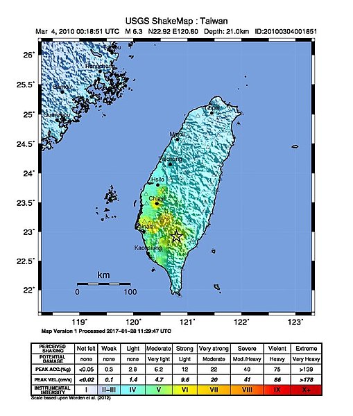
English: Shake map of the magnitude 6.4 earthquake of Taiwan on March 4, 2010. Epicenter marked at star. Sixth version of the map, realized by USGS on 3 MArch 2010 at 06:10:30 MST. |
|||
| Petsa | ||||
| Pinanggalingan | USGS | |||
| May-akda | USGS | |||
| Permiso (Muling paggamit sa file) |
|
| Camera location | | View this and other nearby images on: OpenStreetMap |
|---|
Nakaraan ng file
Pindutin ang araw/oras upang makita kung papaano ang itsura ng talaksan noong oras na iyon.
| Araw/Oras | Thumbnail | Mga dimensiyon | tagagamit | Kumento | |
|---|---|---|---|---|---|
| ngayon | 05:05, 24 Nobyembre 2017 | | 612 × 721 (82 KB) | Alexchris | update |
| 14:05, 12 Hunyo 2016 |  | 612 × 715 (74 KB) | Samchtt | update | |
| 14:03, 12 Hunyo 2016 |  | 612 × 715 (74 KB) | Samchtt | update | |
| 05:03, 4 Marso 2010 |  | 612 × 715 (75 KB) | A-lú-mih | {{Information |Description={{en|1=Shake map of the magnitude 6.4 earthquake of Taiwan on March 4, 2010. Epicenter marked at star. Sixth version of the map, realized by USGS on 3 MArch 2010 at 06:10:30 MST.}} |Source=[http:// |
Mga ugnay
Nakaturo sa talaksan na ito ang mga sumusunod na mga pahina:
Pandaigdigang paggamit sa file
Ginagamit ng mga sumusunod na wiki ang file na ito:
- Paggamit sa en.wikipedia.org
- Paggamit sa es.wikipedia.org
- Paggamit sa fr.wikipedia.org
- Paggamit sa id.wikipedia.org
- Paggamit sa ja.wikipedia.org
- Paggamit sa ms.wikipedia.org
- Paggamit sa nl.wikipedia.org
- Paggamit sa ru.wikipedia.org
- Paggamit sa www.wikidata.org
- Paggamit sa zh-min-nan.wikipedia.org
- Paggamit sa zh.wikipedia.org