
Talaksan:2018 Pacific typhoon season summary.png

Laki ng pasilip na ito: 800 x 600 na pixel. Ibang mga resolusyon: 320 x 240 na pixel | 640 x 480 na pixel | 1,024 x 768 na pixel | 1,280 x 960 na pixel | 2,560 x 1,920 na pixel | 4,000 x 3,000 na pixel.
Buong resolusyon ((4,000 × 3,000 pixel, laki ng talaksan: 7.77 MB, uri ng MIME: image/png))
|
|
Ito ay isang talaksan mula sa Wikimedia Commons. Makikita sa ibaba ang impormasyon mula sa pahina ng paglalarawan nito roon. |
Buod
| Paglalarawan |
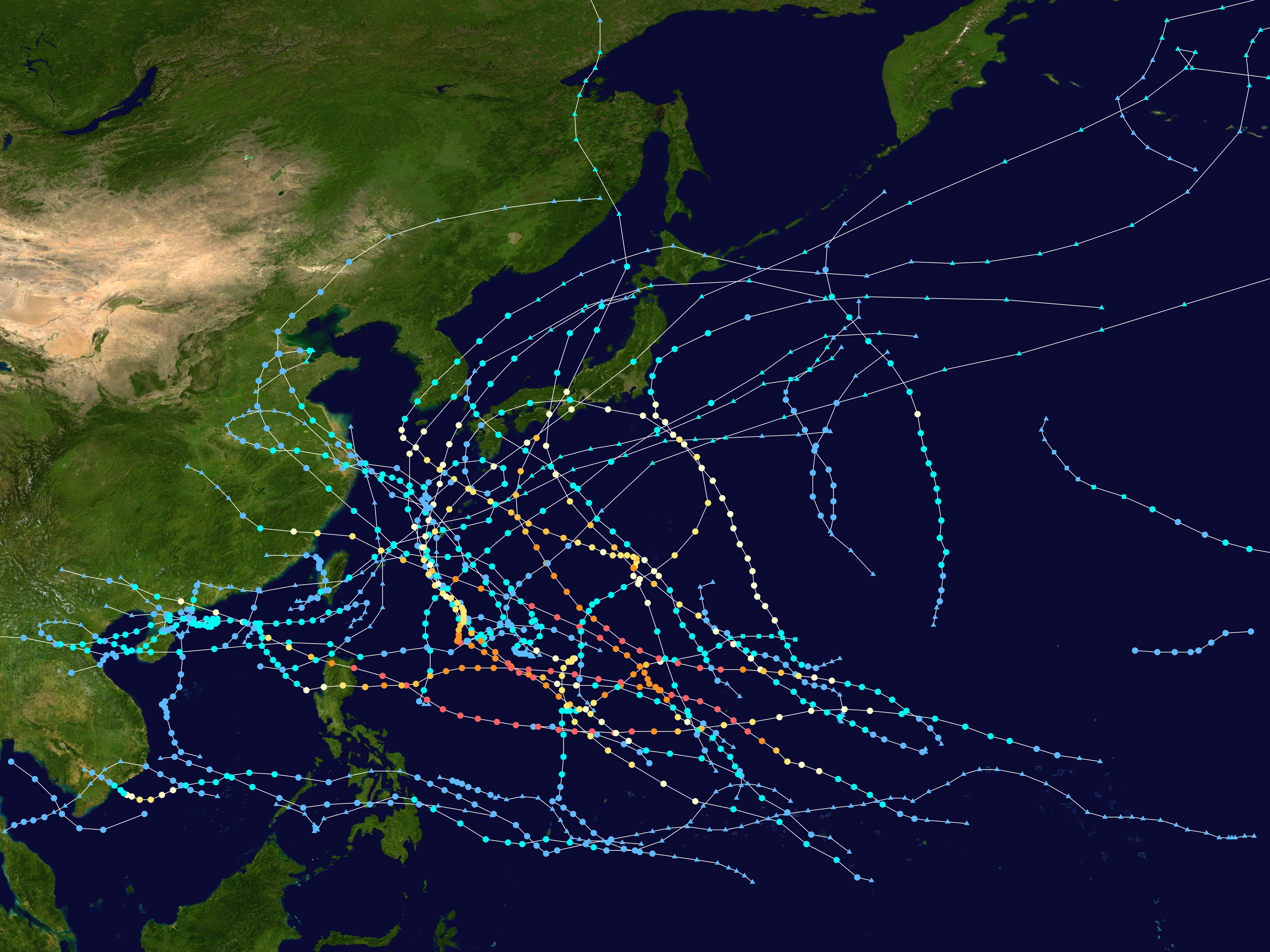
English: This map shows the tracks of all tropical cyclones in the 2018 Pacific typhoon season. The points show the location of each storm at 6-hour intervals. The colour represents the storm's maximum sustained wind speeds as classified in the Saffir-Simpson Hurricane Scale (see below), and the shape of the data points represent the type of the storm. Map generation parameters: --res 4000 --extra 1 --dots 0.2 --lines 0.04 --xmin 100 --xmax 180 --ymin 0 --ymax 60
Tropical depression (≤38 mph, ≤62 km/h)
Tropical storm (39–73 mph, 63–118 km/h)
Category 1 (74–95 mph, 119–153 km/h)
Category 2 (96–110 mph, 154–177 km/h)
Category 3 (111–129 mph, 178–208 km/h)
Category 4 (130–156 mph, 209–251 km/h)
Category 5 (≥157 mph, ≥252 km/h)
Unknown
Storm type |
| Pinanggalingan | Created using Wikipedia:WikiProject Tropical cyclones/Tracks. The background image is from NASA [1]. The tracking data is from the Joint Typhoon Warning Center's best track database |
| May-akda | Keith Edkins |
| Ang akdang ito ay pinakawalan sa sakop ng madla ng may-akda nito, si Keith Edkins. Magagamit ito sa buong daigdig. Maaaring hindi ito posibleng legal sa ilang mga bansa; kung ganito: Ibinibigay ni Keith Edkins kaninuman ang karapatang gamitin ang akdang ito para sa anumang layunin, na walang anumang kundisyon, maliban na lamang kung ang ganyang mga kundisyon ay kinakailangan sa batas. |
Nakaraan ng file
Pindutin ang araw/oras upang makita kung papaano ang itsura ng talaksan noong oras na iyon.
| Araw/Oras | Thumbnail | Mga dimensiyon | tagagamit | Kumento | |
|---|---|---|---|---|---|
| ngayon | 07:14, 11 Hulyo 2020 | | 4,000 × 3,000 (7.77 MB) | Supportstorm | Minor JTWC updates |
| 03:13, 21 Enero 2020 |  | 4,000 × 3,000 (7.77 MB) | Supportstorm | Corrections (Removal of unofficial SS, nonsynoptic data and a TD considered ET. Minor JMA TD data from finalized weather maps) | |
| 13:58, 6 Oktubre 2019 |  | 4,000 × 3,000 (7.62 MB) | Meow | JTWC best track data | |
| 14:46, 12 Enero 2019 |  | 4,000 × 3,000 (7.7 MB) | Meow | 12-30 12Z (Usman) | |
| 14:32, 4 Disyembre 2018 |  | 4,000 × 3,000 (7.67 MB) | Meow | RSMC Tokyo Best Track Data (Trami & Kong-rey) | |
| 14:28, 28 Nobyembre 2018 |  | 4,000 × 3,000 (7.68 MB) | Meow | 11-28 06Z (Toraji, Man-yi and Usagi) | |
| 16:57, 3 Nobyembre 2018 |  | 4,000 × 3,000 (7.62 MB) | Meow | 11-03 12Z (Yutu) | |
| 16:15, 9 Oktubre 2018 |  | 4,000 × 3,000 (7.59 MB) | Meow | 10-08 12Z (Trami & Kong-rey) | |
| 13:52, 28 Setyembre 2018 |  | 4,000 × 3,000 (7.52 MB) | Meow | 09-28 12Z (29W) | |
| 14:31, 19 Setyembre 2018 |  | 4,000 × 3,000 (7.48 MB) | Meow | 09-17 18Z (Mangkhut) |
Mga ugnay
Nakaturo sa talaksan na ito ang mga sumusunod na mga pahina:
Pandaigdigang paggamit sa file
Ginagamit ng mga sumusunod na wiki ang file na ito:
- Paggamit sa de.wikipedia.org
- Paggamit sa en.wikipedia.org
- 2018 Pacific typhoon season
- Template:2018 Pacific typhoon season buttons
- Tropical Storm Bolaven (2018)
- Timeline of the 2018 Pacific typhoon season
- User:Hurricane Noah/Sandbox8
- Tropical Storm Ewiniar (2018)
- Typhoon Maria (2018)
- Tropical Storm Son-Tinh
- Typhoon Jongdari
- Hurricane Hector (2018)
- Tropical Storm Rumbia
- Typhoon Jebi
- Tropical cyclones in 2018
- Typhoon Mangkhut
- Typhoon Yutu
- Tropical Storm Sanba (2018)
- Tropical Storm Bebinca (2018)
- Typhoon Trami
- User:Tfmbty/2018 Pacific typhoon season
- User:Akbermamps/sandbox
- Tropical Depression Usman
- User:Nepbert/2018 Pacific typhoon season
- Typhoon Kong-rey (2018)
- Tropical Storm Yagi (2018)
- Tropical Storm Ampil
- User:Nino Marakot/2018 Pacific typhoon season
- User:Hurricane Noah/Hurricane Hector
- Tropical Storm Toraji (2018)
- Wikipedia:WikiProject Tropical cyclones/2018 FT task force
- Tropical Depression Josie
- User:Hurricane Noah/Meteorological history of Typhoon Mangkhut
- Typhoon Soulik (2018)
- Tropical Storm Usagi (2018)
- User:KN2731/Cimaron
- Typhoon Cimaron (2018)
- Typhoon Prapiroon (2018)
- Tropical Storm Barijat
- Tropical Storm Maliksi (2018)
- User:Akbermamps/Tropical Depression Luis
- Wikipedia talk:WikiProject Tropical cyclones/Archive 48
- Typhoon Jelawat (2018)
- Paggamit sa es.wikipedia.org
- Paggamit sa ja.wikipedia.org
- Paggamit sa ko.wikipedia.org
Tingnan ang karagdagang pandaigdigang paggamit sa file na ito.