
Talaksan:AlexanderIsland.png
Walang resolusyong mataas.
AlexanderIsland.png ((243 × 334 pixel, laki ng talaksan: 33 KB, uri ng MIME: image/png))
|
|
Ito ay isang talaksan mula sa Wikimedia Commons. Makikita sa ibaba ang impormasyon mula sa pahina ng paglalarawan nito roon. |
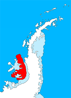
Buod
| Paglalarawan |
English: Outline map of the Antarctic Peninsula showing Alexander Island.
Drawn by me (User:Grutness) based on File:Ant-pen_map.png by Giovanni Fattori. |
| Petsa | 2 Hulyo 2011 (original upload date) |
| Pinanggalingan | Transferred from en.wikipedia |
| May-akda | Original uploader was Grutness at en.wikipedia |
Paglilisensiya

|
Pinapayagan ang pagkopya, pamamahagi, at/o pagbabago sa dokumentong ito sa ilalim ng mga nakasaad sa GNU Free Documentation License, Bersyon 1.2 o kahit anong mas bagong bersyong nilathala ng Free Software Foundation; nang walang pabago-bagong bahagi, walang teksto sa front-cover, at walang teksto sa back-cover. May nakalagay na kopya ng lisensiya sa bahaging pinamagatang GNU Free Documentation License. |
Tala ng orihinal na pagkarga
The original description page was here. All following user names refer to en.wikipedia.
- 2011-07-02 09:27 Grutness 243×334× (34005 bytes) Outline map of the Antarctic Peninsula showing [[Alexander Island]]. Drawn by me (User:Grutness) based on [[:File:Ant-pen_map.png]] by Giovanni Fattori.{{GFDL}}
Nakaraan ng file
Pindutin ang araw/oras upang makita kung papaano ang itsura ng talaksan noong oras na iyon.
| Araw/Oras | Thumbnail | Mga dimensiyon | tagagamit | Kumento | |
|---|---|---|---|---|---|
| ngayon | 18:36, 9 Hulyo 2011 | | 243 × 334 (33 KB) | MGA73bot2 | {{BotMoveToCommons|en.wikipedia|year={{subst:CURRENTYEAR}}|month={{subst:CURRENTMONTHNAME}}|day={{subst:CURRENTDAY}}}} {{Information |Description={{en|Outline map of the Antarctic Peninsula showing en:Alexander Island. Drawn by me (User:Grutness) |
Mga ugnay
Walang mga pahina ang tumuturo sa talaksang ito.
Pandaigdigang paggamit sa file
Ginagamit ng mga sumusunod na wiki ang file na ito:
- Paggamit sa chr.wikipedia.org
- Paggamit sa es.wikipedia.org
- Paggamit sa uk.wikipedia.org