
Talaksan:CIA map Central America & Caribbean.png

Laki ng pasilip na ito: 798 x 599 na pixel. Ibang resolusyon: 320 x 240 na pixel | 639 x 480 na pixel | 1,023 x 768 na pixel | 1,280 x 961 na pixel | 1,390 x 1,044 na pixel.
Buong resolusyon ((1,390 × 1,044 pixel, laki ng talaksan: 1.6 MB, uri ng MIME: image/png))
|
|
Ito ay isang talaksan mula sa Wikimedia Commons. Makikita sa ibaba ang impormasyon mula sa pahina ng paglalarawan nito roon. |
JAY TAMBU MAYALA ENGANGE PAR LA CIA
Buod
| Paglalarawan |
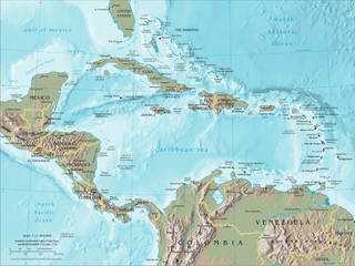
English: Map of Central America and the Caribbean by the CIA World Factbook Español: Mapa de Centroamérica y el Caribe en el CIA World Factbook |
| Pinanggalingan | Transferred from en.wikipedia to Commons. Original source is/was CIA The World Factbook |
| May-akda | U.S. Central Intelligence Agency (CIA) |
| Iba pang mga bersyon |


Paglilisensiya
This image is in the public domain because it contains materials that originally came from the United States Central Intelligence Agency's World Factbook.
|
 |
Tala ng orihinal na pagkarga
The original description page was here. All following user names refer to en.wikipedia.
- 2007-09-20 19:45 Brianski 1392×1066×8 (1720810 bytes) == Summary == Map of [[Central America]], see https://www.cia.gov/library/publications/the-world-factbook/docs/refmaps.html. == License == {{PD-USGov-CIA-WF}}
Nakaraan ng file
Pindutin ang araw/oras upang makita kung papaano ang itsura ng talaksan noong oras na iyon.
| Araw/Oras | Thumbnail | Mga dimensiyon | tagagamit | Kumento | |
|---|---|---|---|---|---|
| ngayon | 22:22, 10 Hunyo 2010 | | 1,390 × 1,044 (1.6 MB) | Jahoe | better compression (no visible alterations) |
| 08:45, 26 Agosto 2008 |  | 1,390 × 1,044 (2.3 MB) | Bowlhover | Cropped title. | |
| 22:01, 25 Setyembre 2007 |  | 1,392 × 1,066 (1.64 MB) | Paintman | {{Information |Description=Map of en:Central America, see https://www.cia.gov/library/publications/the-world-factbook/docs/refmaps.html. |Source=Originally from [http://en.wikipedia.org en.wikipedia]; description page is/was [http://en.wikipedia.org |
Mga ugnay
Nakaturo sa talaksan na ito ang mga sumusunod na mga pahina:
Pandaigdigang paggamit sa file
Ginagamit ng mga sumusunod na wiki ang file na ito:
- Paggamit sa als.wikipedia.org
- Paggamit sa an.wikipedia.org
- Paggamit sa ar.wikipedia.org
- Paggamit sa ast.wikipedia.org
- Paggamit sa bat-smg.wikipedia.org
- Paggamit sa ba.wikipedia.org
- Paggamit sa bm.wikipedia.org
- Paggamit sa bn.wikipedia.org
- Paggamit sa bo.wikipedia.org
- Paggamit sa br.wikipedia.org
- Paggamit sa bs.wikipedia.org
- Paggamit sa co.wikipedia.org
- Paggamit sa cs.wikipedia.org
- Paggamit sa da.wikipedia.org
- Paggamit sa de.wikipedia.org
- Paggamit sa de.wiktionary.org
- Paggamit sa el.wikipedia.org
- Paggamit sa en.wikipedia.org
- Piracy in the Caribbean
- Portal:Latin America/Portals
- Wikipedia:WikiProject Caribbean
- Portal:Piracy/Selected article
- User:Saaristo
- Portal:Piracy/Selected article/10
- User:Zero Gravity/Proposal
- Ocean fisheries
- Wikipedia:Graphics Lab/Image workshop/Archive/Sep 2008
- Portal:Bolivia
- Portal:Bolivia/Related portals
- User:StAnMc18/sandbox
- Paggamit sa en.wikibooks.org
- Paggamit sa eo.wikipedia.org
- Paggamit sa es.wikipedia.org
- Paggamit sa eu.wikipedia.org
- Paggamit sa ext.wikipedia.org
- Paggamit sa fa.wikipedia.org
Tingnan ang karagdagang pandaigdigang paggamit sa file na ito.