
Talaksan:Europe 1783-1792 en.png

Laki ng pasilip na ito: 800 x 570 na pixel. Ibang mga resolusyon: 320 x 228 na pixel | 640 x 456 na pixel | 1,024 x 730 na pixel | 1,280 x 913 na pixel | 2,560 x 1,825 na pixel | 3,872 x 2,761 na pixel.
Buong resolusyon ((3,872 × 2,761 pixel, laki ng talaksan: 1.24 MB, uri ng MIME: image/png))
|
|
Ito ay isang talaksan mula sa Wikimedia Commons. Makikita sa ibaba ang impormasyon mula sa pahina ng paglalarawan nito roon. |
_en.png)
.png)
.jpg)
Buod
| Paglalarawan |
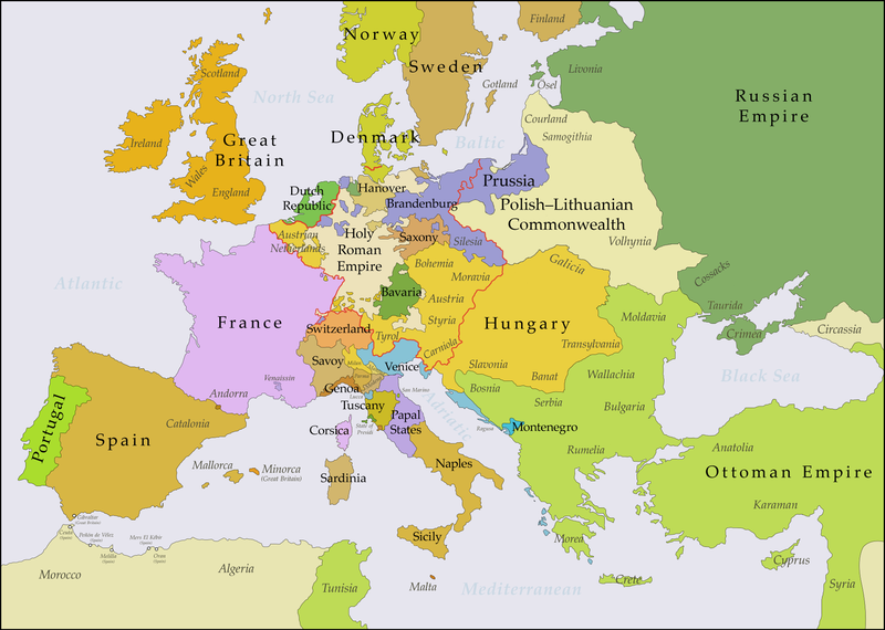
English: This map shows Europe in the years between the 1783 Russian annexation of Crimea after the Russo-Turkish War of 1768–1774 and the Russian annexation of Yedisan in 1792 at the end of the Russo-Turkish War of 1787–1792. The red line marks the borders of the Holy Roman Empire. The work was created with Inkscape and is mainly based on a map in: Putzger - Historischer Weltatlas, Berlin 1990, 78 pp. |
| Petsa | |
| Pinanggalingan | Sariling gawa, based on File:Europe 1748-1766 en.png |
| May-akda | Bryan Rutherford |
Paglilisensiya
Ako, na may karapatang-ari ng akdang ito, ang naglalathala nito alinsunod sa ilalim ng sumusunod na mga lisensya:
Ang talaksang ito ay nakalisensiya sa ilalim ng lisensiyang Creative Commons Atribusyon-Pagpapamahaging Magkatulad 4.0 Pandaigdig.
- Malaya kang:
- para ibahagi – para kopyahin, ipamahagi, at i-transmit ang akda
- para i-remix – para i-adapt ang akda
- Sa ilalim ng mga kondisyong ito:
- atribusyon – Dapat magbigay ka ng isang maayos na pag-credit, ibigay ang link sa lisensiya, at tukuyin kung may mga pagbabagong ginawa. Magagawa mo ito sa isang risonableng paraan, pero hindi sa paraan na para bang ineendorso ka o ng paggamit mo ng naglisensiya sa'yo.
- share alike – Kung ire-remix mo, babaguhin, o magdadagdag ka sa materyal, dapat mong ipamahagi ang mga ambag mo sa ilalim ng pareho o katulad na lisensiya.
| Annotations | This image is annotated: View the annotations at Commons |
Nakaraan ng file
Pindutin ang araw/oras upang makita kung papaano ang itsura ng talaksan noong oras na iyon.
| Araw/Oras | Thumbnail | Mga dimensiyon | tagagamit | Kumento | |
|---|---|---|---|---|---|
| ngayon | 21:47, 15 Hulyo 2018 | | 3,872 × 2,761 (1.24 MB) | Bryanrutherford0 | Added the Ionian Islands, made the Duchy of Milan a Habsburg possession, gave Prussia control of Mansfeld (1780) |
| 02:29, 10 Hulyo 2018 |  | 3,872 × 2,761 (1.23 MB) | Bryanrutherford0 | Added Comtat Venaissin and redrew borders of Neuchâtel, Bishopric Basel, and Montbéliard | |
| 00:46, 3 Oktubre 2017 |  | 3,872 × 2,761 (1.23 MB) | Bryanrutherford0 | Transferred control of Saaremaa and Hiiumaa to Russia (1721 Treaty of Nystad), transferred control of Corsica to France (1769 [[:en:French conquest of Corsica|French conquest of... | |
| 15:03, 30 Setyembre 2017 |  | 3,872 × 2,761 (1.23 MB) | Bryanrutherford0 | Adjusted Russian-Swedish border in Finland to reflect Russian gains in the 1743 Treaty of Åbo after the Russo-Swedish War. | |
| 04:47, 30 Setyembre 2017 |  | 3,872 × 2,761 (1.23 MB) | Bryanrutherford0 | User created page with UploadWizard |
Mga ugnay
Nakaturo sa talaksan na ito ang mga sumusunod na mga pahina:
Pandaigdigang paggamit sa file
Ginagamit ng mga sumusunod na wiki ang file na ito:
- Paggamit sa ar.wikipedia.org
- Paggamit sa bg.wikipedia.org
- Paggamit sa bn.wikipedia.org
- Paggamit sa br.wikipedia.org
- Paggamit sa ca.wikipedia.org
- Paggamit sa el.wikipedia.org
- Paggamit sa en.wikipedia.org
- Paggamit sa es.wikipedia.org
- Paggamit sa fi.wikipedia.org
- Paggamit sa fr.wikipedia.org
- Paggamit sa it.wikipedia.org
- Paggamit sa ja.wikipedia.org
- Paggamit sa ka.wikipedia.org
- Paggamit sa mk.wikipedia.org
- Paggamit sa sl.wikipedia.org
- Paggamit sa th.wikipedia.org
- Paggamit sa uz.wikipedia.org
- Paggamit sa vi.wikipedia.org
- Paggamit sa zh.wikipedia.org