
Talaksan:Fiji map.png
Walang resolusyong mataas.
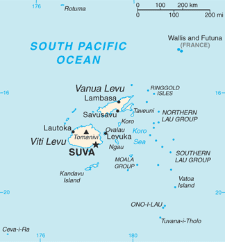
Fiji_map.png ((324 × 349 pixel, laki ng talaksan: 11 KB, uri ng MIME: image/png))
|
|
Ito ay isang talaksan mula sa Wikimedia Commons. Makikita sa ibaba ang impormasyon mula sa pahina ng paglalarawan nito roon. |

|
This map has been uploaded by Electionworld from en.wikipedia.org to enable the |
PNG map of Fiji from CIA World Factbook.
This image is in the public domain because it contains materials that originally came from the United States Central Intelligence Agency's World Factbook.
|
 |
Originally uploaded to English Wikipedia by en:User:Grendelkhan as Fj-map.png.

|
This map image could be re-created using vector graphics as an SVG file. This has several advantages; see Commons:Media for cleanup for more information. If an SVG form of this image is available, please upload it and afterwards replace this template with
{{vector version available|new image name}}.
It is recommended to name the SVG file “Fiji map.svg”—then the template Vector version available (or Vva) does not need the new image name parameter. |
Nakaraan ng file
Pindutin ang araw/oras upang makita kung papaano ang itsura ng talaksan noong oras na iyon.
| Araw/Oras | Thumbnail | Mga dimensiyon | tagagamit | Kumento | |
|---|---|---|---|---|---|
| ngayon | 13:26, 1 Mayo 2013 | | 324 × 349 (11 KB) | Ras67 | cropped |
| 17:14, 16 Setyembre 2012 |  | 328 × 353 (23 KB) | Thricecube | Updated version | |
| 17:33, 26 Hunyo 2012 |  | 326 × 351 (4 KB) | Ras67 | cropped | |
| 03:18, 12 Marso 2005 |  | 330 × 355 (4 KB) | Alexander Ilnitsky~commonswiki | Map of Fiji |
Mga ugnay
Nakaturo sa talaksan na ito ang mga sumusunod na mga pahina:
Pandaigdigang paggamit sa file
Ginagamit ng mga sumusunod na wiki ang file na ito:
- Paggamit sa af.wikipedia.org
- Paggamit sa als.wikipedia.org
- Paggamit sa am.wikipedia.org
- Paggamit sa ang.wikipedia.org
- Paggamit sa ar.wikipedia.org
- Paggamit sa arz.wikipedia.org
- Paggamit sa ast.wikipedia.org
- Paggamit sa azb.wikipedia.org
- Paggamit sa az.wikipedia.org
- Paggamit sa ban.wikipedia.org
- Paggamit sa ba.wikipedia.org
- Paggamit sa bcl.wikipedia.org
- Paggamit sa be-tarask.wikipedia.org
- Paggamit sa bn.wikipedia.org
- Paggamit sa br.wikipedia.org
- Paggamit sa ca.wikipedia.org
- Paggamit sa ceb.wikipedia.org
- Paggamit sa cs.wikipedia.org
- Paggamit sa cy.wikipedia.org
- Paggamit sa de.wikipedia.org
- Paggamit sa de.wikivoyage.org
- Paggamit sa dsb.wikipedia.org
- Paggamit sa el.wikipedia.org
- Paggamit sa en.wikipedia.org
Tingnan ang karagdagang pandaigdigang paggamit sa file na ito.