
Talaksan:Global subducted slabs USGS.png

Laki ng pasilip na ito: 800 x 421 na pixel. Ibang resolusyon: 320 x 169 na pixel | 640 x 337 na pixel | 1,024 x 539 na pixel | 1,280 x 674 na pixel | 2,400 x 1,264 na pixel.
Buong resolusyon ((2,400 × 1,264 pixel, laki ng talaksan: 2.72 MB, uri ng MIME: image/png))
|
|
Ito ay isang talaksan mula sa Wikimedia Commons. Makikita sa ibaba ang impormasyon mula sa pahina ng paglalarawan nito roon. |
Buod
| Paglalarawan |
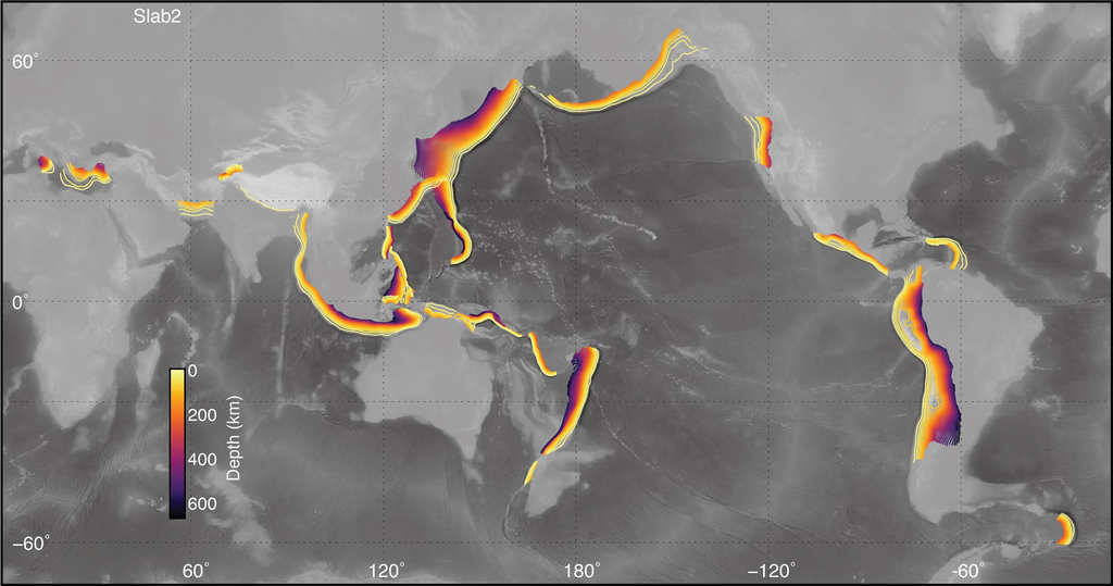
English: Map of subducted slabs, contoured by depth, for most active subduction zones around the globe. Map produced by Gavin P. Hayes (USGS). |
| Petsa | |
| Pinanggalingan | https://www.usgs.gov/media/images/global-distribution-models-included-slab2 |
| May-akda | Gavin P. Hayes |
Paglilisensiya
This image is in the public domain in the United States because it only contains materials that originally came from the United States Geological Survey, an agency of the United States Department of the Interior. For more information, see the official USGS copyright policy.
|
Nakaraan ng file
Pindutin ang araw/oras upang makita kung papaano ang itsura ng talaksan noong oras na iyon.
| Araw/Oras | Thumbnail | Mga dimensiyon | tagagamit | Kumento | |
|---|---|---|---|---|---|
| ngayon | 16:32, 13 Marso 2020 | | 2,400 × 1,264 (2.72 MB) | Mikenorton | Uploaded a work by Gavin P. Hayes from https://www.usgs.gov/media/images/global-distribution-models-included-slab2 with UploadWizard |
Mga ugnay
Nakaturo sa talaksan na ito ang mga sumusunod na mga pahina:
Pandaigdigang paggamit sa file
Ginagamit ng mga sumusunod na wiki ang file na ito:
- Paggamit sa af.wikipedia.org
- Paggamit sa ban.wikipedia.org
- Paggamit sa bn.wikipedia.org
- Paggamit sa de.wikipedia.org
- Paggamit sa en.wikipedia.org
- Paggamit sa es.wikipedia.org
- Paggamit sa fr.wikipedia.org
- Paggamit sa id.wikipedia.org
- Paggamit sa it.wikipedia.org
- Paggamit sa it.wikibooks.org
- Paggamit sa it.wikiversity.org
- Paggamit sa mk.wikipedia.org
- Paggamit sa ru.wikipedia.org
- Paggamit sa tr.wikipedia.org
- Paggamit sa zh.wikipedia.org