
Talaksan:Gulf stream map.gif
Buong resolusyon ((700 × 612 pixel, laki ng talaksan: 222 KB, uri ng MIME: image/gif))
|
|
Ito ay isang talaksan mula sa Wikimedia Commons. Makikita sa ibaba ang impormasyon mula sa pahina ng paglalarawan nito roon. |
Buod

|
This file was moved to Wikimedia Commons from en.wikipedia using a bot script. All source information is still present. It requires review. Additionally, there may be errors in any or all of the information fields; information on this file should not be considered reliable and the file should not be used until it has been reviewed and any needed corrections have been made. Once the review has been completed, this template should be removed. For details about this file, see below. Check now! |
| Paglalarawan |
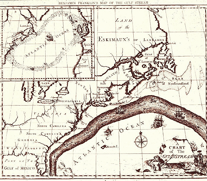
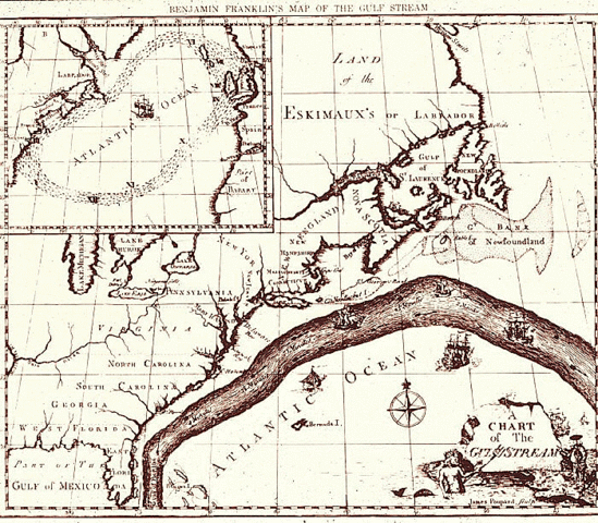
English: Map of the Gulf Stream by Benjamin Franklin. Courtesy of NOAA Photo Library. |
| Petsa | 1769 - 1770 |
| Pinanggalingan | http://oceanexplorer.noaa.gov/library/readings/gulf/media/gulf_bf.html |
| May-akda | Benjamin Franklin |
| Permiso (Muling paggamit sa file) |
Public Domain |
Paglilisensiya
|
This work is in the public domain in its country of origin and other countries and areas where the copyright term is the author's life plus 70 years or fewer.
| |
| Nakilala ang talaksan bilang malaya mula sa nalalamang mga paghahangga sa ilalim ng batas sa karapatang-ari, kasama ang lahat ng mga kaugnay at karatig na mga karapatan. | |
Tala ng orihinal na pagkarga
Transferred from en.wikipedia to Commons by Sreejithk2000 using CommonsHelper.
- 2010-01-04 09:22 Zeamays 700×612× (227284 bytes) {{Information |Description = Map of the Gulf Stream by Benjamin Franklin. Courtesy of NOAA Photo Library. |Source = http://oceanexplorer.noaa.gov/library/readings/gulf/media/gulf_bf.html |Date = 1769-1770 |Author = Benjami
Nakaraan ng file
Pindutin ang araw/oras upang makita kung papaano ang itsura ng talaksan noong oras na iyon.
| Araw/Oras | Thumbnail | Mga dimensiyon | tagagamit | Kumento | |
|---|---|---|---|---|---|
| ngayon | 06:23, 5 Hunyo 2010 | | 700 × 612 (222 KB) | File Upload Bot (Magnus Manske) | {{BotMoveToCommons|en.wikipedia|year={{subst:CURRENTYEAR}}|month={{subst:CURRENTMONTHNAME}}|day={{subst:CURRENTDAY}}}} {{Information |Description={{en|Map of the Gulf Stream by Benjamin Franklin. Courtesy of NOAA Photo Library.}} |Source=Transferred from |
Mga ugnay
Nakaturo sa talaksan na ito ang mga sumusunod na mga pahina:
Pandaigdigang paggamit sa file
Ginagamit ng mga sumusunod na wiki ang file na ito:
- Paggamit sa da.wikipedia.org
- Paggamit sa da.wikibooks.org
- Paggamit sa en.wikipedia.org
- Paggamit sa fr.wikipedia.org
- Paggamit sa hy.wikipedia.org
- Paggamit sa id.wikipedia.org
- Paggamit sa kn.wikipedia.org
- Paggamit sa ko.wikipedia.org
- Paggamit sa la.wikipedia.org
- Paggamit sa mk.wikipedia.org
- Paggamit sa oc.wikipedia.org
- Paggamit sa si.wikipedia.org
- Paggamit sa ta.wikipedia.org