
Talaksan:Lower Egypt-en.png

Laki ng pasilip na ito: 600 x 600 na pixel. Ibang resolusyon: 240 x 240 na pixel | 480 x 480 na pixel | 994 x 994 na pixel.
Buong resolusyon ((994 × 994 pixel, laki ng talaksan: 188 KB, uri ng MIME: image/png))
|
|
Ito ay isang talaksan mula sa Wikimedia Commons. Makikita sa ibaba ang impormasyon mula sa pahina ng paglalarawan nito roon. |
Buod
| Paglalarawan |
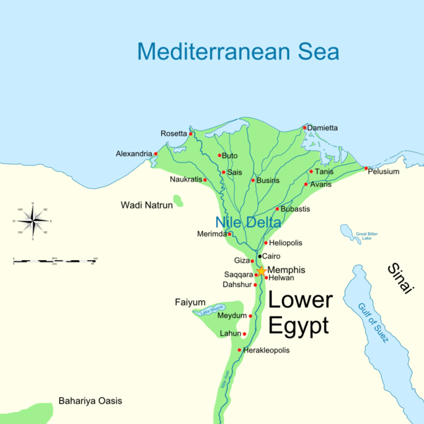
English: Map of Lower Ancient Egypt, showing the Nile and major cities and sites of the Dynastic period (c. 3150 BC to 30 BC). |
| Petsa | (UTC) |
| Pinanggalingan | |
| May-akda |
|
| Iba pang mga bersyon |
Derivative works of this file: |

|
This historical map image could be re-created using vector graphics as an SVG file. This has several advantages; see Commons:Media for cleanup for more information. If an SVG form of this image is available, please upload it and afterwards replace this template with
{{vector version available|new image name}}.
It is recommended to name the SVG file “Lower Egypt-en.svg”—then the template Vector version available (or Vva) does not need the new image name parameter. |
| This is a retouched picture, which means that it has been digitally altered from its original version. Modifications: Cropped image to use as base map. The original can be viewed here: Ancient Egypt map-en.svg:
|
Paglilisensiya
Ako, na may karapatang-ari ng akdang ito, ang naglalathala nito alinsunod sa ilalim ng sumusunod na mga lisensya:
Ang talaksang ito ay nakalisensiya sa ilalim ng lisensiyang Creative Commons Atribusyon-Pagpapamahaging Magkatulad 3.0 Walang Daungan, 2.5 Heneriko, 2.0 Heneriko at 1.0 Heneriko.
- Malaya kang:
- para ibahagi – para kopyahin, ipamahagi, at i-transmit ang akda
- para i-remix – para i-adapt ang akda
- Sa ilalim ng mga kondisyong ito:
- atribusyon – Dapat magbigay ka ng isang maayos na pag-credit, ibigay ang link sa lisensiya, at tukuyin kung may mga pagbabagong ginawa. Magagawa mo ito sa isang risonableng paraan, pero hindi sa paraan na para bang ineendorso ka o ng paggamit mo ng naglisensiya sa'yo.
- share alike – Kung ire-remix mo, babaguhin, o magdadagdag ka sa materyal, dapat mong ipamahagi ang mga ambag mo sa ilalim ng pareho o katulad na lisensiya.

|
Pinapayagan ang pagkopya, pamamahagi, at/o pagbabago sa dokumentong ito sa ilalim ng mga nakasaad sa GNU Free Documentation License, Bersyon 1.2 o kahit anong mas bagong bersyong nilathala ng Free Software Foundation; nang walang pabago-bagong bahagi, walang teksto sa front-cover, at walang teksto sa back-cover. May nakalagay na kopya ng lisensiya sa bahaging pinamagatang GNU Free Documentation License. |
Makakapili ka ng lisensiyang gusto mo.
Tala ng orihinal na pagkarga
This image is a derivative work of the following images:
- File:Ancient_Egypt_map-en.svg licensed with Cc-by-sa-3.0,2.5,2.0,1.0, GFDL
- 2009-02-20T11:28:29Z Bibi Saint-Pol 1577x3219 (422457 Bytes) fix translation mistake on the windrose
- 2009-01-30T12:13:53Z Bibi Saint-Pol 1577x3219 (422444 Bytes) fix position of Nile Delta
- 2009-01-29T12:21:11Z Bibi Saint-Pol 1577x3219 (422383 Bytes) remove wrong text, adjust frame
- 2009-01-29T12:05:11Z Bibi Saint-Pol 1577x3219 (422757 Bytes) {{Assessments|1=Ancient Egypt map.svg|enwiki=1}} __NOTOC__ == {{int:filedesc}} == {{inkscape}} {{Information |Description= {{en|Map of Ancient Egypt, showing the Nile up to the fifth cataract, and major cities and sites of th
Uploaded with derivativeFX
Nakaraan ng file
Pindutin ang araw/oras upang makita kung papaano ang itsura ng talaksan noong oras na iyon.
| Araw/Oras | Thumbnail | Mga dimensiyon | tagagamit | Kumento | |
|---|---|---|---|---|---|
| ngayon | 16:30, 14 Pebrero 2014 | | 994 × 994 (188 KB) | Andy king50 | -border |
| 18:00, 29 Hunyo 2009 |  | 1,000 × 1,000 (193 KB) | MinisterForBadTimes | Hopefully fixed border this time | |
| 17:59, 29 Hunyo 2009 |  | 1,000 × 1,000 (193 KB) | MinisterForBadTimes | Moved border | |
| 17:57, 29 Hunyo 2009 |  | 1,000 × 1,000 (193 KB) | MinisterForBadTimes | Added border | |
| 17:49, 29 Hunyo 2009 |  | 1,000 × 1,000 (190 KB) | MinisterForBadTimes | {{Information |Description={{en|Map of Lower Ancient Egypt, showing the Nile and major cities and sites of the Dynastic period (c. 3150 BC to 30 BC). |Source=*File:Ancient_Egypt_map-en.svg |Date=2009-06-29 18:49 (UTC) |Author=*[[:File:Ancient_Egypt_ |
Mga ugnay
Nakaturo sa talaksan na ito ang mga sumusunod na mga pahina:
Pandaigdigang paggamit sa file
Ginagamit ng mga sumusunod na wiki ang file na ito:
- Paggamit sa ar.wikipedia.org
- Paggamit sa arz.wikipedia.org
- Paggamit sa az.wikipedia.org
- Paggamit sa bg.wikipedia.org
- Paggamit sa br.wikipedia.org
- Paggamit sa cs.wikipedia.org
- Paggamit sa de.wikipedia.org
- Paggamit sa de.wikivoyage.org
- Paggamit sa el.wikipedia.org
- Paggamit sa en.wikipedia.org
- Paggamit sa es.wikipedia.org
- Paggamit sa et.wikipedia.org
- Paggamit sa eu.wikipedia.org
- Paggamit sa fr.wikipedia.org
- Paggamit sa he.wikipedia.org
- Paggamit sa hu.wikipedia.org
- Paggamit sa it.wikipedia.org
- Paggamit sa ja.wikipedia.org
Tingnan ang karagdagang pandaigdigang paggamit sa file na ito.