
Talaksan:Map Anatolia ancient regions-en.svg

Buong resolusyon ((Larawang SVG, tinatayang 921 × 596 mga pixel, laki ng talakasan: 256 KB))
|
|
Ito ay isang talaksan mula sa Wikimedia Commons. Makikita sa ibaba ang impormasyon mula sa pahina ng paglalarawan nito roon. |
| Paglalarawan |
Català: Mapa regional d'Àsia Menor al segle II aC
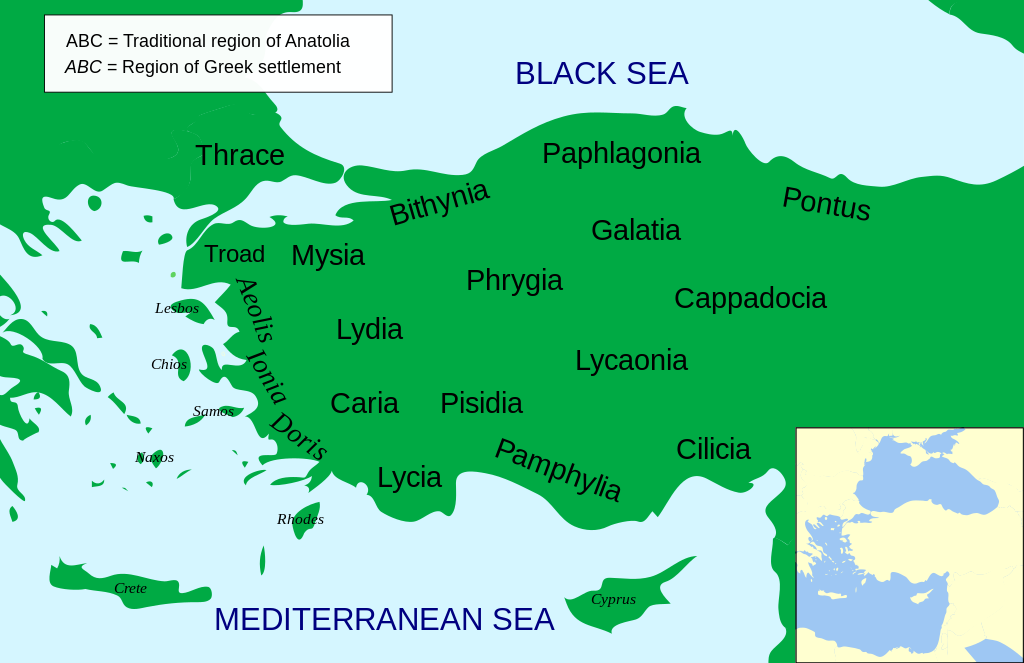
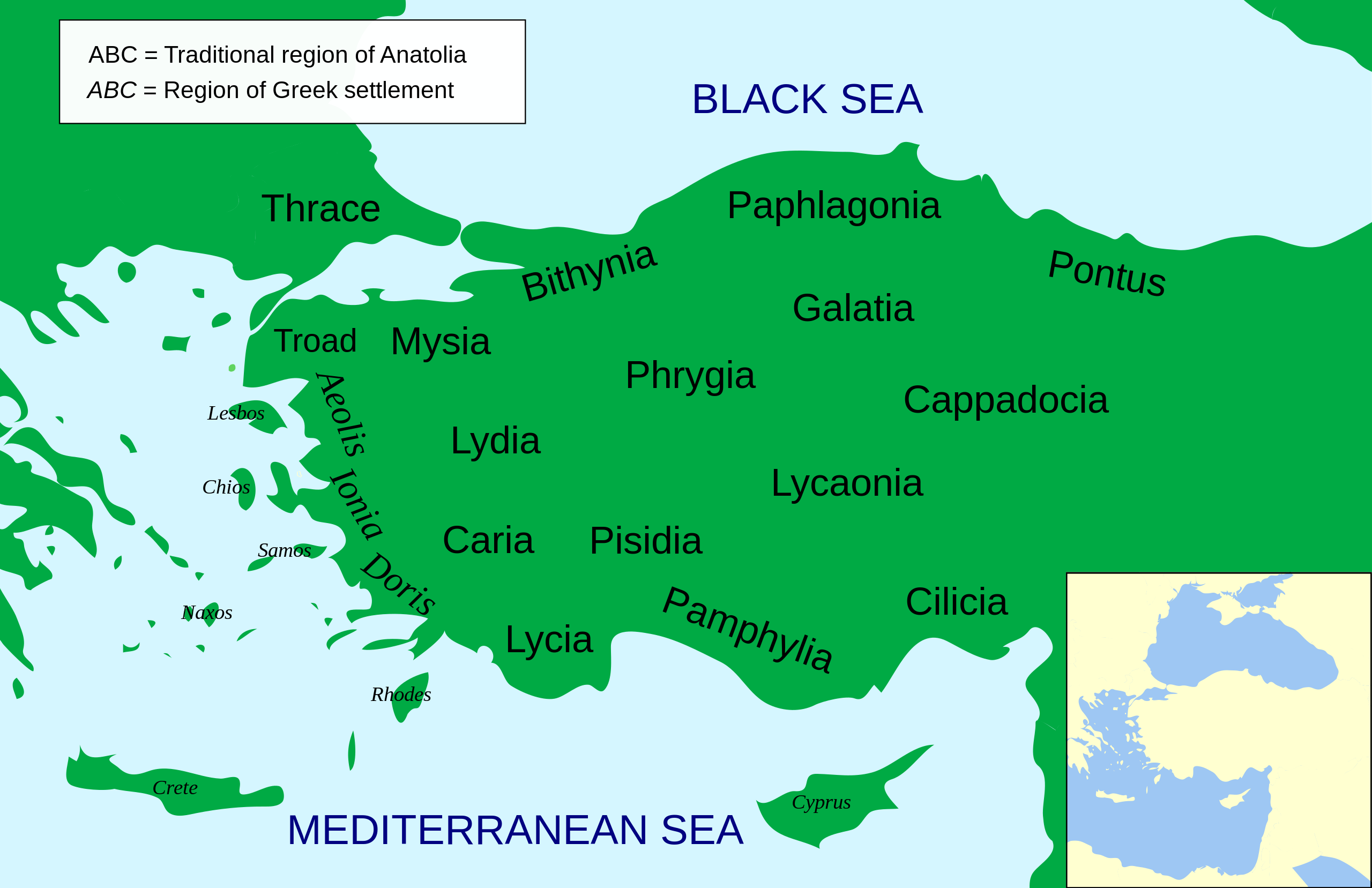
English: Regional map of Asia Minor in the 2nd Century BC |
| Petsa | (UTC) |
| Pinanggalingan | |
| May-akda |
|
| Iba pang mga bersyon |
Other related versions: []
Derivative works of this file: |


.svg)


|
This SVG file contains embedded text that can be translated into your language, using any capable SVG editor, text editor or the SVG Translate tool. For more information see: About translating SVG files. |
This file is translated using SVG <switch> elements. All translations are stored in the same file! Learn more.
For most Wikipedia projects, you can embed the file normally (without a To translate the text into your language, you can use the SVG Translate tool. Alternatively, you can download the file to your computer, add your translations using whatever software you're familiar with, and re-upload it with the same name. You will find help in Graphics Lab if you're not sure how to do this. |
| This is a retouched picture, which means that it has been digitally altered from its original version. Modifications: Increased legibility, slight corrections in position. The original can be viewed here: Asia Minor Political 500BC.svg:
|
- Malaya kang:
- para ibahagi – para kopyahin, ipamahagi, at i-transmit ang akda
- para i-remix – para i-adapt ang akda
- Sa ilalim ng mga kondisyong ito:
- atribusyon – Dapat magbigay ka ng isang maayos na pag-credit, ibigay ang link sa lisensiya, at tukuyin kung may mga pagbabagong ginawa. Magagawa mo ito sa isang risonableng paraan, pero hindi sa paraan na para bang ineendorso ka o ng paggamit mo ng naglisensiya sa'yo.
- share alike – Kung ire-remix mo, babaguhin, o magdadagdag ka sa materyal, dapat mong ipamahagi ang mga ambag mo sa ilalim ng pareho o katulad na lisensiya.

|
Pinapayagan ang pagkopya, pamamahagi, at/o pagbabago sa dokumentong ito sa ilalim ng mga nakasaad sa GNU Free Documentation License, Bersyon 1.2 o kahit anong mas bagong bersyong nilathala ng Free Software Foundation; nang walang pabago-bagong bahagi, walang teksto sa front-cover, at walang teksto sa back-cover. May nakalagay na kopya ng lisensiya sa bahaging pinamagatang GNU Free Documentation License. |
Tala ng orihinal na pagkarga
This image is a derivative work of the following images:
- File:Asia_Minor_Political_500BC.svg licensed with Cc-by-sa-3.0, GFDL
- 2009-04-22T07:38:42Z MinisterForBadTimes 921x596 (283615 Bytes) Coloured in rogue region
- 2009-04-22T07:36:20Z MinisterForBadTimes 921x596 (283353 Bytes) Changed fonts...again
- 2009-04-22T07:33:39Z MinisterForBadTimes 921x596 (283414 Bytes) Changed fonts
- 2009-04-22T07:25:50Z MinisterForBadTimes 921x596 (284262 Bytes) {{Information |Description={{en|1= Political map of Asia Minor in 500 BC}} |Source=*[[:File:Mysia.svg|]] |Date=2009-04-22 08:23 (UTC) |Author=*[[:File:Mysia.svg|]]: [[User:Emok|Emok]] *derivative work: *[[:Image:Mysia_map_anc
Uploaded with derivativeFX
Nakaraan ng file
Pindutin ang araw/oras upang makita kung papaano ang itsura ng talaksan noong oras na iyon.
| Araw/Oras | Thumbnail | Mga dimensiyon | tagagamit | Kumento | |
|---|---|---|---|---|---|
| ngayon | 14:14, 15 Pebrero 2024 | | 921 × 596 (256 KB) | Manlleus | File uploaded using svgtranslate tool (https://svgtranslate.toolforge.org/). Added translation for ca. |
| 14:01, 15 Pebrero 2024 |  | 921 × 596 (235 KB) | Manlleus | fixed text labels for translation | |
| 19:48, 23 Abril 2009 |  | 921 × 596 (278 KB) | MinisterForBadTimes | Added Galatia, minor other changes | |
| 16:01, 22 Abril 2009 |  | 921 × 596 (277 KB) | MinisterForBadTimes | {{Information |Description={{en|1= Political map of Asia Minor in 500 BC}} |Source=*File:Asia_Minor_Political_500BC.svg |Date=2009-04-22 17:00 (UTC) |Author=*File:Asia_Minor_Political_500BC.svg: *Mysia.svg: [[User:Emok|Emok |
Mga ugnay
Nakaturo sa talaksan na ito ang mga sumusunod na mga pahina:
Pandaigdigang paggamit sa file
Ginagamit ng mga sumusunod na wiki ang file na ito:
- Paggamit sa af.wikipedia.org
- Paggamit sa als.wikipedia.org
- Paggamit sa am.wikipedia.org
- Paggamit sa ar.wikipedia.org
- Paggamit sa azb.wikipedia.org
- Paggamit sa az.wikipedia.org
- Paggamit sa be-tarask.wikipedia.org
- Paggamit sa bg.wikipedia.org
- Paggamit sa bn.wikipedia.org
- Paggamit sa br.wikipedia.org
- Paggamit sa bs.wikipedia.org
- Paggamit sa ca.wikipedia.org
- Paggamit sa cs.wikipedia.org
- Paggamit sa da.wikipedia.org
- Paggamit sa de.wikipedia.org
- Paggamit sa diq.wikipedia.org
- Paggamit sa en.wikipedia.org
Tingnan ang karagdagang pandaigdigang paggamit sa file na ito.