
Talaksan:Map of Ohio NA.png

Laki ng pasilip na ito: 800 x 542 na pixel. Ibang resolusyon: 320 x 217 na pixel | 640 x 434 na pixel | 1,024 x 694 na pixel | 1,280 x 867 na pixel | 1,967 x 1,333 na pixel.
Buong resolusyon ((1,967 × 1,333 pixel, laki ng talaksan: 2.02 MB, uri ng MIME: image/png))
|
|
Ito ay isang talaksan mula sa Wikimedia Commons. Makikita sa ibaba ang impormasyon mula sa pahina ng paglalarawan nito roon. |
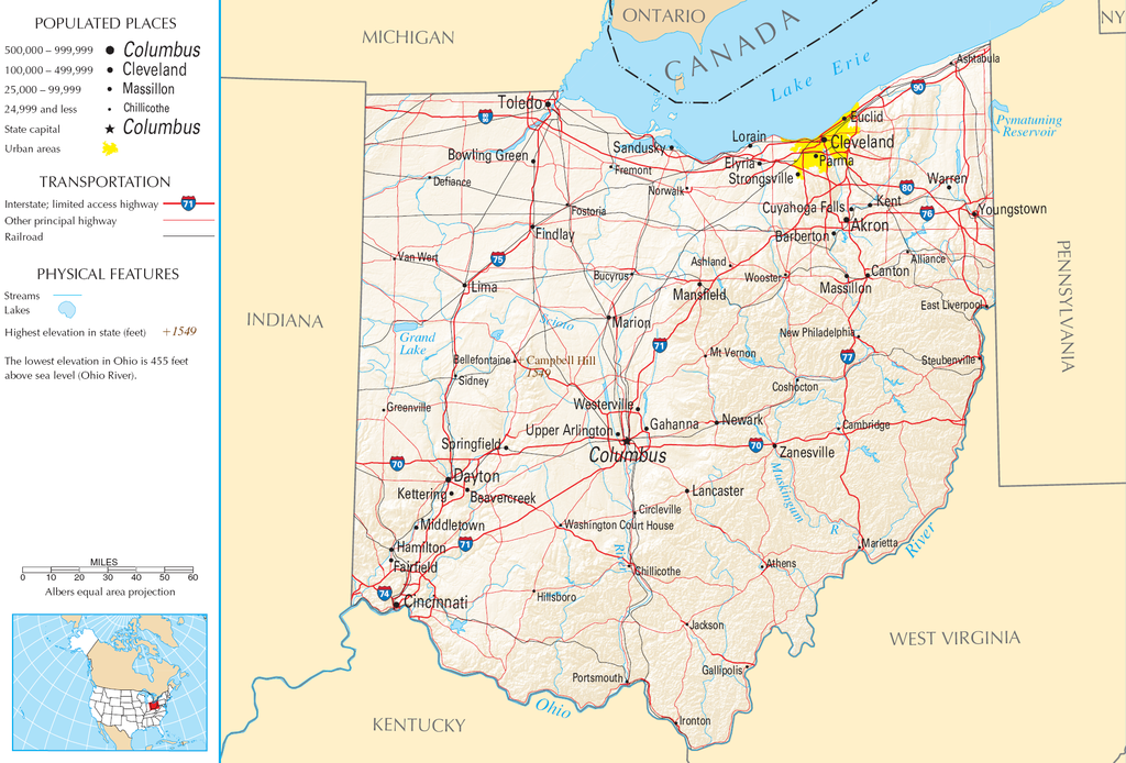
| Paglalarawan | Map of Ohio |
| Pinanggalingan | National Atlas |
| May-akda |
This map was obtained from an edition of the National Atlas of the United States. Like almost all works of the U.S. federal government, works from the National Atlas are in the public domain in the United States.
Online access: NationalAtlas.gov | 1970 print edition: Library of Congress, Perry-Castañeda Library
|
Nakaraan ng file
Pindutin ang araw/oras upang makita kung papaano ang itsura ng talaksan noong oras na iyon.
| Araw/Oras | Thumbnail | Mga dimensiyon | tagagamit | Kumento | |
|---|---|---|---|---|---|
| ngayon | 11:21, 30 Agosto 2007 | | 1,967 × 1,333 (2.02 MB) | Conscious | cropped |
| 08:02, 15 Agosto 2006 |  | 2,122 × 1,640 (2.17 MB) | Huebi~commonswiki | {{Information| |Description=Map of Ohio |Source=[http://www.nationalatlas.gov National Atlas] }} Category:Maps of the United States Category:Maps of Ohio {{PD-USGov-Atlas}} |
Mga ugnay
Walang mga pahina ang tumuturo sa talaksang ito.
Pandaigdigang paggamit sa file
Ginagamit ng mga sumusunod na wiki ang file na ito:
- Paggamit sa arz.wikipedia.org
- Paggamit sa de.wikipedia.org
- Paggamit sa en.wikipedia.org
- Paggamit sa es.wikipedia.org
- Paggamit sa eu.wikipedia.org
- Paggamit sa fr.wikipedia.org
- Paggamit sa gl.wikipedia.org
- Paggamit sa hr.wiktionary.org
- Paggamit sa hsb.wikipedia.org
- Paggamit sa hu.wikipedia.org
- Paggamit sa incubator.wikimedia.org
- Paggamit sa io.wikipedia.org
- Paggamit sa it.wikipedia.org
- Paggamit sa ja.wikipedia.org
- Paggamit sa kk.wikipedia.org
- Paggamit sa mk.wikipedia.org
- Paggamit sa mr.wikipedia.org
- Paggamit sa nl.wikipedia.org
- Paggamit sa rue.wikipedia.org
- Paggamit sa ru.wikipedia.org
- Paggamit sa stq.wikipedia.org
- Paggamit sa sw.wikipedia.org
- Paggamit sa szl.wikipedia.org
- Paggamit sa zea.wikipedia.org