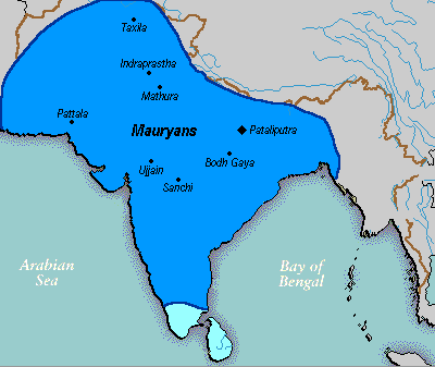
Talaksan:Mauryan Empire Map.gif
Mauryan_Empire_Map.gif ((400 × 337 pixel, laki ng talaksan: 11 KB, uri ng MIME: image/gif))
Nakaraan ng file
Pindutin ang araw/oras upang makita kung papaano ang itsura ng talaksan noong oras na iyon.
| Araw/Oras | Thumbnail | Mga dimensiyon | tagagamit | Kumento | |
|---|---|---|---|---|---|
| ngayon | 00:16, 25 Marso 2016 |  | 400 × 337 (11 KB) | LouisAragon | rv, changes made by a banned user. |
| 01:14, 23 Abril 2007 |  | 400 × 337 (11 KB) | Jagged 85 | ||
| 23:02, 13 Disyembre 2006 |  | 400 × 337 (11 KB) | Electionworld | {{ew|en|Vastu}} {{ShouldBeSVG}} ==Description== A poltical map of the Mauryan Empire, including notable cities, such as the capital Pataliputra, and site of the Buddha's enlightenment. ===Key=== Dark blue represents the extend of the Maur |
Mga ugnay
Nakaturo sa talaksan na ito ang mga sumusunod na mga pahina:
Pandaigdigang paggamit sa file
Ginagamit ng mga sumusunod na wiki ang file na ito:
- Paggamit sa anp.wikipedia.org
- Paggamit sa bh.wikipedia.org
- Paggamit sa bn.wikipedia.org
- Paggamit sa bpy.wikipedia.org
- Paggamit sa ca.wikipedia.org
- Paggamit sa cs.wikipedia.org
- Paggamit sa cy.wikipedia.org
- Paggamit sa da.wikipedia.org
- Paggamit sa en.wikipedia.org
- Paggamit sa eo.wikipedia.org
- Paggamit sa fa.wikipedia.org
- Paggamit sa fi.wikipedia.org
- Paggamit sa fi.wikibooks.org
- Paggamit sa fr.wikipedia.org
- Paggamit sa gu.wikipedia.org
- Paggamit sa he.wikipedia.org
- Paggamit sa hi.wikipedia.org
- Paggamit sa it.wikipedia.org
- Paggamit sa ka.wikipedia.org
- Paggamit sa ko.wikipedia.org
- Paggamit sa la.wikipedia.org
- Paggamit sa lt.wikipedia.org
- Paggamit sa lv.wikipedia.org
- Paggamit sa ml.wikipedia.org
- Paggamit sa mr.wikipedia.org
- Paggamit sa ne.wikipedia.org
- Paggamit sa nl.wikipedia.org
Tingnan ang karagdagang pandaigdigang paggamit sa file na ito.


