
Talaksan:Mt Vesuvius 79 AD eruption.svg

Size of this PNG preview of this SVG file: 800 x 482 na pixel. Ibang resolusyon: 320 x 193 na pixel | 640 x 386 na pixel | 1,024 x 617 na pixel | 1,280 x 771 na pixel | 2,560 x 1,542 na pixel.
Buong resolusyon ((Larawang SVG, tinatayang 800 × 482 mga pixel, laki ng talakasan: 87 KB))
|
|
Ito ay isang talaksan mula sa Wikimedia Commons. Makikita sa ibaba ang impormasyon mula sa pahina ng paglalarawan nito roon. |
Buod
| Paglalarawan |
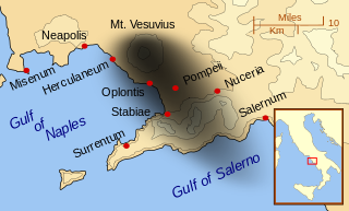
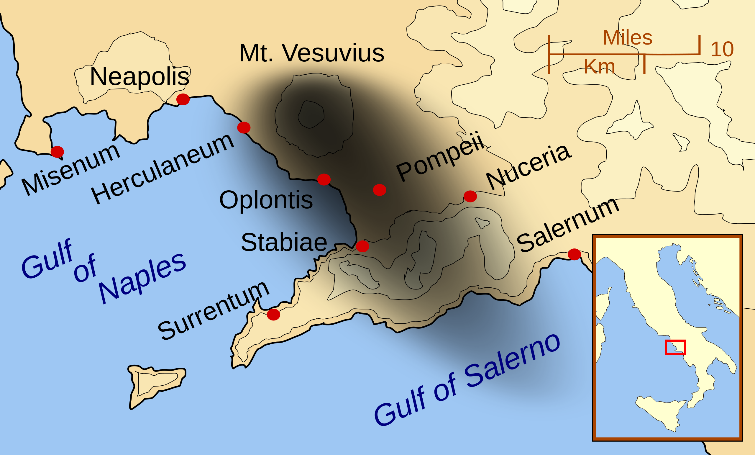
English: A map showing the cities and towns affected by the eruption of Mount Vesuvius in 79 AD. The general shape of the ash and cinder fall (see w:en:pyroclast) is shown by the dark area to the southeast of Mt Vesuvius. (P.S. It seems strange to show the modern day English names for the two bodies of water - I am open to suggestions).
This map shows lines and uses the Mercator projection (although that is not important on a map of this scale). North is, as usual, at the top of the map. |
| Petsa | |
| Pinanggalingan | Sariling gawa |
| May-akda | MapMaster |
| Iba pang mga bersyon |
[]
|


|
This SVG file contains embedded text that can be translated into your language, using any capable SVG editor, text editor or the SVG Translate tool. For more information see: About translating SVG files. |
Paglilisensiya
Ako, na may karapatang-ari ng akdang ito, ang naglalathala nito alinsunod sa ilalim ng sumusunod na mga lisensya:

|
Pinapayagan ang pagkopya, pamamahagi, at/o pagbabago sa dokumentong ito sa ilalim ng mga nakasaad sa GNU Free Documentation License, Bersyon 1.2 o kahit anong mas bagong bersyong nilathala ng Free Software Foundation; nang walang pabago-bagong bahagi, walang teksto sa front-cover, at walang teksto sa back-cover. May nakalagay na kopya ng lisensiya sa bahaging pinamagatang GNU Free Documentation License. |
Ang talaksang ito ay nakalisensiya sa ilalim ng lisensiyang Creative Commons Atribusyon-Pagpapamahaging Magkatulad 3.0 Walang Daungan, 2.5 Heneriko, 2.0 Heneriko at 1.0 Heneriko.
- Malaya kang:
- para ibahagi – para kopyahin, ipamahagi, at i-transmit ang akda
- para i-remix – para i-adapt ang akda
- Sa ilalim ng mga kondisyong ito:
- atribusyon – Dapat magbigay ka ng isang maayos na pag-credit, ibigay ang link sa lisensiya, at tukuyin kung may mga pagbabagong ginawa. Magagawa mo ito sa isang risonableng paraan, pero hindi sa paraan na para bang ineendorso ka o ng paggamit mo ng naglisensiya sa'yo.
- share alike – Kung ire-remix mo, babaguhin, o magdadagdag ka sa materyal, dapat mong ipamahagi ang mga ambag mo sa ilalim ng pareho o katulad na lisensiya.
Makakapili ka ng lisensiyang gusto mo.
| Annotations | This image is annotated: View the annotations at Commons |
Nakaraan ng file
Pindutin ang araw/oras upang makita kung papaano ang itsura ng talaksan noong oras na iyon.
| Araw/Oras | Thumbnail | Mga dimensiyon | tagagamit | Kumento | |
|---|---|---|---|---|---|
| ngayon | 01:55, 24 Pebrero 2014 | | 800 × 482 (87 KB) | Ras67 | ditto |
| 01:42, 24 Pebrero 2014 |  | 644 × 388 (88 KB) | Ras67 | frame removed | |
| 01:07, 16 Oktubre 2007 |  | 652 × 396 (113 KB) | MapMaster | corrected mis-named Gulf of Salerno | |
| 04:02, 15 Oktubre 2007 |  | 652 × 396 (112 KB) | MapMaster | Dropped Title sqaure, and added towns and names of the 2 bays. | |
| 05:16, 14 Oktubre 2007 |  | 652 × 454 (126 KB) | MapMaster | Minor changes made after seeing how it's rendered by Wikimedia | |
| 05:11, 14 Oktubre 2007 |  | 355 × 247 (125 KB) | MapMaster | {{Information |Description=A map showing the cities and town affected by the eruption of Mount Vesuvius in 79 AD. The general shape of the ash and cinder fall is shown by the dark area to the southeast of Mt Vesuvious. |Source=self-made |Date=October 200 |
Mga ugnay
Pandaigdigang paggamit sa file
Ginagamit ng mga sumusunod na wiki ang file na ito:
- Paggamit sa ar.wikipedia.org
- Paggamit sa bn.wikipedia.org
- Paggamit sa ca.wikipedia.org
- Paggamit sa cs.wikipedia.org
- Paggamit sa da.wikipedia.org
- Paggamit sa de.wikipedia.org
- Paggamit sa el.wikipedia.org
- Paggamit sa en.wikipedia.org
- Paggamit sa eo.wikipedia.org
- Paggamit sa es.wikipedia.org
- Paggamit sa eu.wikipedia.org
- Paggamit sa fa.wikipedia.org
- Paggamit sa fi.wikipedia.org
- Paggamit sa fr.wikipedia.org
- Paggamit sa ga.wikipedia.org
- Paggamit sa gl.wikipedia.org
- Paggamit sa he.wikipedia.org
- Paggamit sa hr.wikipedia.org
- Paggamit sa hu.wikipedia.org
- Paggamit sa hyw.wikipedia.org
- Paggamit sa id.wikipedia.org
- Paggamit sa is.wikipedia.org
Tingnan ang karagdagang pandaigdigang paggamit sa file na ito.