
Talaksan:New 2000 white percent.gif

Laki ng pasilip na ito: 776 x 600 na pixel. Ibang resolusyon: 311 x 240 na pixel | 621 x 480 na pixel | 994 x 768 na pixel | 1,280 x 989 na pixel | 2,604 x 2,012 na pixel.
Buong resolusyon ((2,604 × 2,012 pixel, laki ng talaksan: 700 KB, uri ng MIME: image/gif))
|
|
Ito ay isang talaksan mula sa Wikimedia Commons. Makikita sa ibaba ang impormasyon mula sa pahina ng paglalarawan nito roon. |

|
File:New 2000 white percent.svg is a vector version of this file. It should be used in place of this GIF file when not inferior.
File:New 2000 white percent.gif → File:New 2000 white percent.svg
For more information, see Help:SVG. |
 |
Buod
| Paglalarawan |
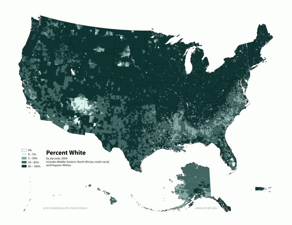
English: Map of US, showing percentage of population self-reporting as "White," by census tract, 2000. Data source: US Census similar maps:
|
| Petsa | |
| Pinanggalingan | Own work by the original uploader |
| May-akda | Citynoise at English Wikipedia |
| Permiso (Muling paggamit sa file) |
Original text: I am the designer and creator of this map and license it under the Creative Commons Attribution ShareAlike 2.5 License. |
Paglilisensiya
Ang talaksang ito ay nakalisensiya sa ilalim ng lisensiyang Creative Commons Atribusyon-Pagpapamahaging Magkatulad 2.5 Heneriko.
- Malaya kang:
- para ibahagi – para kopyahin, ipamahagi, at i-transmit ang akda
- para i-remix – para i-adapt ang akda
- Sa ilalim ng mga kondisyong ito:
- atribusyon – Dapat magbigay ka ng isang maayos na pag-credit, ibigay ang link sa lisensiya, at tukuyin kung may mga pagbabagong ginawa. Magagawa mo ito sa isang risonableng paraan, pero hindi sa paraan na para bang ineendorso ka o ng paggamit mo ng naglisensiya sa'yo.
- share alike – Kung ire-remix mo, babaguhin, o magdadagdag ka sa materyal, dapat mong ipamahagi ang mga ambag mo sa ilalim ng pareho o katulad na lisensiya.
Tala ng orihinal na pagkarga
The original description page was here. All following user names refer to en.wikipedia.
| Petsa/Oras | Sukat | Tagagamit | Komento |
|---|---|---|---|
| 2010-05-01 19:19 | 2604×2012× (716328 bytes) | Citynoise | Added Alaska, Hawaii, and Territories. Also changed from tracts to zip codes. |
| 2006-04-03 02:10 | 1012×691× (74299 bytes) | Citynoise | Map of contiguous US, showing percentage of population self-reporting as "White," by census tract, 2000. Data source: US Census. I am the designer and creator of this map and license it under the Creative Commons Attribution ShareAlike 2.5 License. |
Nakaraan ng file
Pindutin ang araw/oras upang makita kung papaano ang itsura ng talaksan noong oras na iyon.
| Araw/Oras | Thumbnail | Mga dimensiyon | tagagamit | Kumento | |
|---|---|---|---|---|---|
| ngayon | 04:26, 17 Agosto 2015 | | 2,604 × 2,012 (700 KB) | OgreBot | (BOT): Reverting to most recent version before archival |
| 04:26, 17 Agosto 2015 |  | 1,012 × 691 (73 KB) | OgreBot | (BOT): Uploading old version of file from en.wikipedia; originally uploaded on 2006-04-03 02:10:33 by Citynoise | |
| 04:26, 17 Agosto 2015 |  | 2,604 × 2,012 (700 KB) | Innotata | {{Vector version available|New 2000 white percent.svg}} == {{int:filedesc}} == {{Information |Description={{en|Map of US, showing percentage of population self-reporting as "White," by census tract, 2000. Data source: US Census<br/> similar maps: *[[:e... |
Mga ugnay
Nakaturo sa talaksan na ito ang mga sumusunod na mga pahina:
Pandaigdigang paggamit sa file
Ginagamit ng mga sumusunod na wiki ang file na ito:
- Paggamit sa bg.wikipedia.org
- Paggamit sa en.wikipedia.org