
Talaksan:Scandinavia.TMO2003050.jpg

Buong resolusyon ((5,600 × 7,200 pixel, laki ng talaksan: 7.42 MB, uri ng MIME: image/jpeg))
|
|
Ito ay isang talaksan mula sa Wikimedia Commons. Makikita sa ibaba ang impormasyon mula sa pahina ng paglalarawan nito roon. |
|

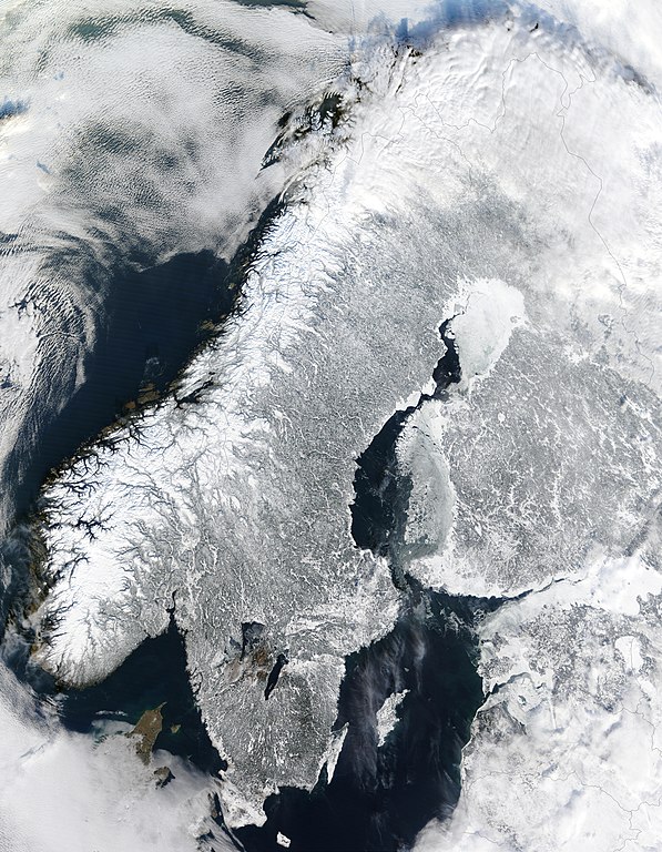
This image was selected as picture of the day on Wikimedia Commons for 12 January 2005. It was captioned as follows: English: Scandinavia from space in winter. Other languages:
Čeština: Zimní Skandinávie při pohledu z vesmíru Deutsch: Winterliches Skandinavien aus dem Weltraum gesehen English: Scandinavia from space in winter. Español: La Península Escandinava en invierno vista desde el espacio Esperanto: Skandinavio de spaco vintre. Français : Vue depuis orbite terrestre de la péninsule scandinave en hiver. Italiano: Vista della Scandinavia innevata dallo spazio. Nederlands: Satellietfoto van Scandinavië in de winter Português: Escandinávia vista do espaço no inverno. Română: Scandinavia din spațiu, iarna Suomi: Kuva talvisesta Fenno-Skandiasta ja Baltiasta avaruudesta kuvattuna Svenska: Satellitbild på ett vintrigt Skandinavien Türkçe: İskandinavya'nın kışın uzaydan uydu aracılığıyla çekilmiş bir görüntüsü. 한국어: 스칸디나비아의 위성사진. 日本語: スカンジナビアの衛星写真 |
Buod
| Paglalarawan |
English: Scandinavia from space in winter.
The Moderate Resolution Imaging Spectroradiometer (MODIS) instrument aboard NASA’s Terra satellite captured the above image of the Scandinavian Peninsula on February 19, 2003. Español: Escandinavia en invierno, imagen de la NASA
Français : Scandinavie en hiver depuis l'espace. Image prise par l'instrument MODIS à bord du satellite Terra de la NASA.
Avec ses paysages sculptés par les glaciers du quaternaire, la Scandinavie en hiver est aussi pittoresque que froide. À l'ouest sont visibles les étroits bras de mer appelés fjords, qui ponctuent la côte norvégienne. Ces fjords très profonds (plus de 600 m et jusque 1 308 m dans le Sognefjord) ont été creusés par de lourds glaciers au cours des âges glaciaires. Ces glaciers descendus de la montagne ont creusé leurs vallées bien en dessous du niveau de la mer. À la fin de la glaciation, c'est donc la mer qui a envahi ces profondes vallées. Nederlands: Satellietopname van Noorwegen, Zweden en Finland in de winter
Română: Peninsula Sandinavă în timpul iernii — vedere din satelit (19 februarie 2003).
Русский: Скандинавский полуостров зимой (19 февраля 2003)
Svenska: Satellitbild över Skandinavien. I Norge finns det fjordar, i Sverige sjöar och i Finland också. Hela halvön är täckt av snö på vintern. Även om det är kallt om vintern nu, så var det ännu kallare på istiden. |
| Petsa | Kinuha noong 19 Pebrero 2003 |
| Pinanggalingan | |
| May-akda | Jacques Descloitres, MODIS Land Rapid Response Team at NASA GSFC |
| Permiso (Muling paggamit sa file) |
Quote of http://rapidfire.sci.gsfc.nasa.gov/faq/ - All the images that appear on our site are in the public domain and can be freely used and reproduced for any purpose. Please credit the MODIS Rapid Response Project appropriately: "Image courtesy of MODIS Rapid Response Project at NASA/GSFC". |
Paglilisensiya
| This file is in the public domain in the United States because it was solely created by NASA. NASA copyright policy states that "NASA material is not protected by copyright unless noted". (See Template:PD-USGov, NASA copyright policy page or JPL Image Use Policy.) | ||
 |
Warnings:
|
Nakaraan ng file
Pindutin ang araw/oras upang makita kung papaano ang itsura ng talaksan noong oras na iyon.
| Araw/Oras | Thumbnail | Mga dimensiyon | tagagamit | Kumento | |
|---|---|---|---|---|---|
| ngayon | 03:06, 2 Enero 2005 | | 5,600 × 7,200 (7.42 MB) | Ed g2s | larger |
| 00:56, 21 Disyembre 2004 |  | 540 × 611 (127 KB) | Mschlindwein | Scandinavia from space in winter |
Mga ugnay
Nakaturo sa talaksan na ito ang mga sumusunod na mga pahina:
Pandaigdigang paggamit sa file
Ginagamit ng mga sumusunod na wiki ang file na ito:
- Paggamit sa af.wikipedia.org
- Paggamit sa ar.wikipedia.org
- Paggamit sa ast.wikipedia.org
- Paggamit sa az.wikipedia.org
- Paggamit sa ba.wikipedia.org
- Paggamit sa be.wikipedia.org
- Paggamit sa bg.wikipedia.org
- Paggamit sa bn.wikibooks.org
- Paggamit sa br.wikipedia.org
- Paggamit sa ca.wikipedia.org
- Paggamit sa ceb.wikipedia.org
- Paggamit sa co.wikipedia.org
- Paggamit sa cs.wikipedia.org
- Paggamit sa da.wikipedia.org
- Paggamit sa de.wikipedia.org
- Schweden
- Skandinavien
- Nordeuropa
- Skandinavische Halbinsel
- Wikipedia:Kandidaten für exzellente Bilder/Archiv2005/6
- Datei:Scandinavia.TMO2003050.jpg
- Portal:Schweden/Qualität
- Benutzer:Torinberl/Testterrain
- Benutzer:Torinberl/Benutzerseite
- Portal:Schweden/Bild der Woche/2007
- Wikipedia:Exzellente Bilder/Karten und Satellitenbilder
- Benutzer:Cristof/Themen3
- Benutzer:Cristof/Themen3/Geographie
- Benutzer:Cristof/Themen3/ConGeographie
- Benutzer:Cristof/Themen3/ Geographie
- Benutzer:Cristof/ Themen3
- Benutzer:Cristof/Themen31
- Benutzer:Cristof/ Themen31
- Portal Diskussion:Schweden/Archiv/2009
- Benutzer:Tidoni/Top Bilder
Tingnan ang karagdagang pandaigdigang paggamit sa file na ito.