
Talaksan:SeychellesBIOT1970.jpg
Walang resolusyong mataas.
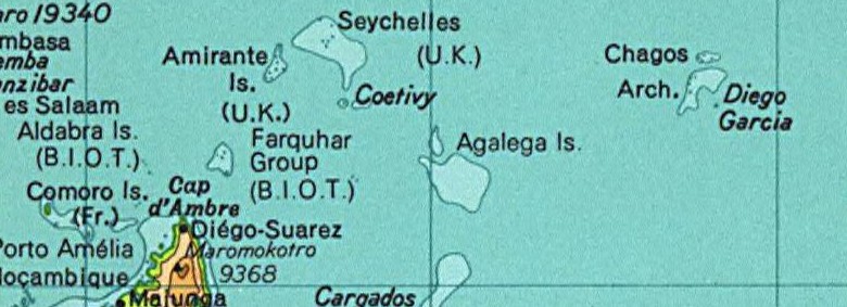
SeychellesBIOT1970.jpg ((780 × 283 pixel, laki ng talaksan: 72 KB, uri ng MIME: image/jpeg))
|
|
Ito ay isang talaksan mula sa Wikimedia Commons. Makikita sa ibaba ang impormasyon mula sa pahina ng paglalarawan nito roon. |
Map of the Seychelles and British Indian Ocean Territory prior to 1976. From the National Atlas as mirrored by the PCL.
This map was obtained from an edition of the National Atlas of the United States. Like almost all works of the U.S. federal government, works from the National Atlas are in the public domain in the United States.
Online access: NationalAtlas.gov | 1970 print edition: Library of Congress, Perry-Castañeda Library
|
This map was cropped from there.
Nakaraan ng file
Pindutin ang araw/oras upang makita kung papaano ang itsura ng talaksan noong oras na iyon.
| Araw/Oras | Thumbnail | Mga dimensiyon | tagagamit | Kumento | |
|---|---|---|---|---|---|
| ngayon | 02:01, 13 Agosto 2005 | 780 × 283 (72 KB) | Hoshie | Map of the Seychelles and British Indian Ocean Territory piror to 1976. From the National Atlas as mirrored by the [http://www.lib.utexas.edu/maps/ PCL]. {{PD-USGov-Atlas}} {{PD-PCL|http://www.lib.utexas.edu/maps/national_atlas_1970/ca000244_large.jpg}} |
Mga ugnay
Nakaturo sa talaksan na ito ang mga sumusunod na mga pahina:
Pandaigdigang paggamit sa file
Ginagamit ng mga sumusunod na wiki ang file na ito:
- Paggamit sa af.wikipedia.org
- Paggamit sa ast.wikipedia.org
- Paggamit sa ca.wikipedia.org
- Paggamit sa el.wikipedia.org
- Paggamit sa en.wikipedia.org
- Paggamit sa eo.wikipedia.org
- Paggamit sa id.wikipedia.org
- Paggamit sa zh.wikipedia.org