
Talaksan:TristanDaCunha.jpg

Walang resolusyong mataas.
TristanDaCunha.jpg ((440 × 340 pixel, laki ng talaksan: 3 KB, uri ng MIME: image/jpeg))
|
|
Ito ay isang talaksan mula sa Wikimedia Commons. Makikita sa ibaba ang impormasyon mula sa pahina ng paglalarawan nito roon. |
Buod
| Paglalarawan |
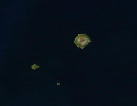
Satellite picture of the Tristan da Cunha Islands, South Atlantic Ocean Deutsch: Satellitenaufnahme von Tristan da Cunha
Español: El archipiélago en una imagen obtenida por un satélite.
Suomi: Satelliittikuva saarista
Français : Vue satellite de l'archipel. L'île de Tristan da Cunha est la plus grande île. À sa gauche se situent de haut en bas l'île Inaccessible et l'île Nightingale
Italiano: Tristan da Cunha e isole circostanti(immagine da satellite)
Polski: Zdjęcie satelitarne archipelagu
Русский: Вид архипелага из космоса (кроме острова Гоф) |
| Petsa | |
| Pinanggalingan | http://eoimages.gsfc.nasa.gov/images/imagerecords/69000/69741/TristanDaCunha.A2003354.1500.250m.jpg |
| May-akda | Image courtesy of MODIS Rapid Response Project at NASA/GSFC |
| Permiso (Muling paggamit sa file) |
http://visibleearth.nasa.gov/useterms.php |
Paglilisensiya
| This file is in the public domain in the United States because it was solely created by NASA. NASA copyright policy states that "NASA material is not protected by copyright unless noted". (See Template:PD-USGov, NASA copyright policy page or JPL Image Use Policy.) | ||
 |
Warnings:
|
| Annotations | This image is annotated: View the annotations at Commons |
Nakaraan ng file
Pindutin ang araw/oras upang makita kung papaano ang itsura ng talaksan noong oras na iyon.
| Araw/Oras | Thumbnail | Mga dimensiyon | tagagamit | Kumento | |
|---|---|---|---|---|---|
| ngayon | 07:43, 4 Enero 2005 | | 440 × 340 (3 KB) | Veinsworld | Tristan da Cunha |
Mga ugnay
Nakaturo sa talaksan na ito ang mga sumusunod na mga pahina:
Pandaigdigang paggamit sa file
Ginagamit ng mga sumusunod na wiki ang file na ito:
- Paggamit sa af.wikipedia.org
- Paggamit sa an.wikipedia.org
- Paggamit sa arz.wikipedia.org
- Paggamit sa ast.wikipedia.org
- Paggamit sa br.wikipedia.org
- Paggamit sa ca.wikipedia.org
- Paggamit sa ceb.wikipedia.org
- Paggamit sa cy.wikipedia.org
- Paggamit sa de.wikipedia.org
- Paggamit sa de.wikivoyage.org
- Paggamit sa en.wikipedia.org
- Paggamit sa eo.wikipedia.org
- Paggamit sa es.wikipedia.org
- Paggamit sa fi.wikipedia.org
- Paggamit sa fi.wiktionary.org
- Paggamit sa fr.wikipedia.org
- Paggamit sa fr.wikivoyage.org
- Paggamit sa gl.wikipedia.org
- Paggamit sa hr.wikipedia.org
- Paggamit sa ig.wikipedia.org
- Paggamit sa it.wikipedia.org
- Paggamit sa ka.wikipedia.org
- Paggamit sa no.wikipedia.org
- Paggamit sa oc.wikipedia.org
- Paggamit sa pap.wikipedia.org
- Paggamit sa pl.wikipedia.org
- Paggamit sa pt.wikipedia.org
- Paggamit sa ru.wikipedia.org
- Paggamit sa simple.wikipedia.org
- Paggamit sa vec.wikipedia.org
- Paggamit sa www.wikidata.org