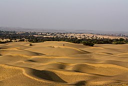
Disyertong Thar
| Disyertong Thar Thar Desert | |
| Great Indian Desert | |
Disyertong Thar sa Rajasthan, India
| |
| Mga bansa | |
|---|---|
| Estado | India: Rajasthan Haryana Punjab Gujarat Pakistan: Sindh Punjab |
| Biyoma | Disyerto |
| Plant | thorn scrub forest |
| Animal | Chinkara |

Ang Disyertong Thar o Ilang ng Thar (Ingles: Thar Desert), na kilala rin bilang Dakilang Ilang ng Indiyano (Ingles: Great Indian Desert), ay isang malaki at tuyong rehiyon sa hilaga-kanlurang bahagi ng Indian subcontinent na bumubuo sa isang likas na hangganan sa pagitan ng India at Pakistan. Ito ay ang pampitong pinakamalaking disyerto sa mundo, at ang pansiyam na pinakamalaking disyertong subtropiko sa mundo.[1] Nasa 75% ng Disyertong Thar ay nasa India, at ang natitirang 25% ay sa Pakistan.[2] Sa India, umaabot ito sa mga 320,000 kilometro kuwadrado (120,000 milya kuwadrado), at bumubuo sa mga 10% ng kabuuang lawak pangheograpiya ng India. Higit sa 60% ng disyerto ay matatagpuan sa estado ng Rajasthan at umaabot sa Gujarat, Punjab, at Haryana.[3]
Mga sanggunian
[baguhin | baguhin ang wikitext]- ↑ Singhvi, A. K. and Kar, A. (1992). Thar Desert in Rajasthan: Land, Man & Environment. Geological Society of India, Bangalore.
- ↑ Sinha, R. K., Bhatia, S., & Vishnoi, R. (1996). Desertification control and rangeland management in the Thar desert of India. RALA Report No. 200: 115–123.
- ↑ Sharma, K. K. and S. P. Mehra (2009). The Thar of Rajasthan (India): Ecology and Conservation of a Desert Ecosystem. Chapter 1 in: Sivaperuman, C., Baqri, Q. H., Ramaswamy, G., & Naseema, M. (eds.) Faunal ecology and conservation of the Great Indian Desert. Springer, Berlin Heidelberg.
Mga karagdagang babasahin
[baguhin | baguhin ang wikitext]- Bhandari M.M.- Flora of The Indian Desert, MPS Repros, 39, BGKT Extension, New Pali Road, Jodhpur, India.
- Zaigham, N. A. (2003). Strategic sustainable development of groundwater in Thar Desert of Pakistan. Water Resources in the South: Present Scenario and Future Prospects, Commission on Science and Technology for Sustainable Development in the South, Islamabad.
- Govt. of India. Ministry of Food & Agriculture booklet (1965)—soil conservation in the Rajasthan Desert—Work of the Desert Afforestation Research station, Jodhpur.
- Gupta, R.K. & Prakash Ishwar (1975). Environmental analysis of the Thar Desert. English Book Depot., Dehra Dun.
- Kaul, R.N. (1967). Trees or grass lands in the Rajasthan: Old problems and New approaches. Indian Forester, 93: 434-435.
- Burdak, L.R. (1982). Recent Advances in Desert Afforestation. Dissertation submitted to Shri R.N. Kaul, Director, Forestry Research, F.R.I., Dehra Dun.
- Yashpal, Sahai Baldev, Sood, R.K., and Agarwal, D.P. (1980). "Remote sensing of the 'lost' Saraswati river". Proceedings of the Indian Academy of Sciences (Earth and Planet Science), V. 89, No. 3, pp. 317–331.
- Bakliwal, P.C. and Sharma, S.B. (1980). "On the migration of the river Yamuna". Journal of the Geological Society of India, Vol. 21, Sept. 1980, pp. 461–463.
- Bakliwal, P.C. and Grover, A.K. (1988). "Signature and migration of Sarasvati river in Thar desert, Western India". Record of the Geological Survey of India V 116, Pts. 3–8, pp. 77–86.
- Rajawat, A.S., Sastry, C.V.S. and Narain, A. (1999-a). Application of pyramidal processing on high resolution IRS-1C data for tracing the migration of the Saraswati river in parts of the Thar desert. in "Vedic Sarasvati, Evolutionary History of a Lost River of Northwestern India", Memoir Geological Society of India, Bangalore, No. 42, pp. 259–272.
- Ramasamy, S.M. (1999). Neotectonic controls on the migration of Sarasvati river of the Great Indian desert. in "Vedic Sarasvati, Evolutionary History of a Lost River of Northwestern India", Memoir Geological Society of India, Bangalore, No. 42, pp. 153–162.
- Rajesh Kumar, M., Rajawat, A.S. and Singh, T.N. (2005). Applications of remote sensing for educidate the Palaeochannels in an extended Thar desert, Western Rajasthan, 8th annual International conference, Map India 2005, New Delhi.
Mga ugnay panlabas
[baguhin | baguhin ang wikitext] Gabay panlakbay sa Disyertong Thar mula sa Wikivoyage
- "Thar Desert". Terrestrial Ecoregions. World Wildlife Fund.
- Dharssi.org.uk Naka-arkibo 2016-03-02 sa Wayback Machine., Photos of the Thar desert
- Avgustin.net Naka-arkibo 2008-02-16 sa Wayback Machine., Photos of the Thar desert in Pakistan side
- MIT.gov[patay na link], आपणो राजस्थान
26°59′04″N 71°00′06″E / 26.98444°N 71.00167°E
![]() Ang lathalaing ito na tungkol sa Heograpiya ay isang usbong. Makatutulong ka sa Wikipedia sa pagpapalawig nito.
Ang lathalaing ito na tungkol sa Heograpiya ay isang usbong. Makatutulong ka sa Wikipedia sa pagpapalawig nito.

