
Talaksan:1827 Finley Map of Turkey in Europe, Greece and the Balkans - Geographicus - TurkeyEurope-finley-1827.jpg

Buong resolusyon ((2,339 × 3,000 pixel, laki ng talaksan: 1.94 MB, uri ng MIME: image/jpeg))
|
|
Ito ay isang talaksan mula sa Wikimedia Commons. Makikita sa ibaba ang impormasyon mula sa pahina ng paglalarawan nito roon. |
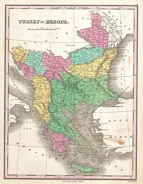
| Anthony Finley: Turkey in Europe.
( |
||||||||||||||
|---|---|---|---|---|---|---|---|---|---|---|---|---|---|---|
| Artista |
|
|||||||||||||
| Pamagat |
Turkey in Europe. |
|||||||||||||
| Paglalarawan |
English: A beautiful example of Finley's rare 1827 map of Turkey in Europe. Covers the European lands claimed by the Ottoman Empire in the early 19th century. This includes the modern day nations of Turkey, Greece, Macedonia, Albania, Croatia, Bosnia, Serbia, Montenegro, Bulgaria, Romania and Moldova. In Finley's classic minimalist style, this map identifies cities, forests, river systems, swamps and mountains. Color coded according to regional political boundaries. Title and scale in upper left quadrant. Engraved by Young and Delleker for the 1827 edition of Anthony Finley's General Atlas . |
|||||||||||||
| Petsa | 1827 (undated) | |||||||||||||
| Sukat | height: 11.5 in (29.2 cm); width: 9 in (22.8 cm) | |||||||||||||
| Bilang sa pagtatamo |
Geographicus link: TurkeyEurope-finley-1827 |
|||||||||||||
| Pinagmulan/Litratista |
Finley, Anthony, A New General Altas, Comprising a Complete Set of Maps, representing the Grand Divisions of the Globe, Together with the several Empires, Kingdoms and States in the World; Compiled from the Best Authorities, and corrected by the Most Recent Discoveries, Philadelphia, 1827.
|
|||||||||||||
| Permiso (Muling paggamit sa file) |
|
|||||||||||||
| Annotations | This image is annotated: View the annotations at Commons |
Nakaraan ng file
Pindutin ang araw/oras upang makita kung papaano ang itsura ng talaksan noong oras na iyon.
| Araw/Oras | Thumbnail | Mga dimensiyon | tagagamit | Kumento | |
|---|---|---|---|---|---|
| ngayon | 15:35, 16 Nobyembre 2022 | | 2,339 × 3,000 (1.94 MB) | Gyalu22 | Reverted overwriting of artwork |
| 18:45, 8 Enero 2020 |  | 2,339 × 3,000 (4.01 MB) | Julieta39 | Cleaning freckles, contrast. | |
| 10:10, 23 Marso 2011 |  | 2,339 × 3,000 (1.94 MB) | BotMultichillT | {{subst:User:Multichill/Geographicus |link=http://www.geographicus.com/P/AntiqueMap/TurkeyEurope-finley-1827 |product_name=1827 Finley Map of Turkey in Europe, Greece and the Balkans |map_title=Turkey in Europe. |description=A beautiful example of Finley' |
Mga ugnay
Nakaturo sa talaksan na ito ang mga sumusunod na mga pahina:
Pandaigdigang paggamit sa file
Ginagamit ng mga sumusunod na wiki ang file na ito:
- Paggamit sa de.wikipedia.org
- Paggamit sa en.wikipedia.org
- Paggamit sa fr.wikipedia.org
- Paggamit sa hr.wikipedia.org
- Paggamit sa it.wikipedia.org
- Paggamit sa ka.wikipedia.org
- Paggamit sa ro.wikipedia.org
- Paggamit sa sh.wikipedia.org
- Paggamit sa sq.wikipedia.org
- Paggamit sa tr.wikipedia.org