
Talaksan:2008 Pacific typhoon season summary.jpg
Laki ng pasilip na ito: 800 x 526 na pixel. Ibang resolusyon: 320 x 211 na pixel | 640 x 421 na pixel | 1,024 x 674 na pixel | 1,280 x 842 na pixel | 3,000 x 1,974 na pixel.
Buong resolusyon ((3,000 × 1,974 pixel, laki ng talaksan: 698 KB, uri ng MIME: image/jpeg))
|
|
Ito ay isang talaksan mula sa Wikimedia Commons. Makikita sa ibaba ang impormasyon mula sa pahina ng paglalarawan nito roon. |
| Paglalarawan |
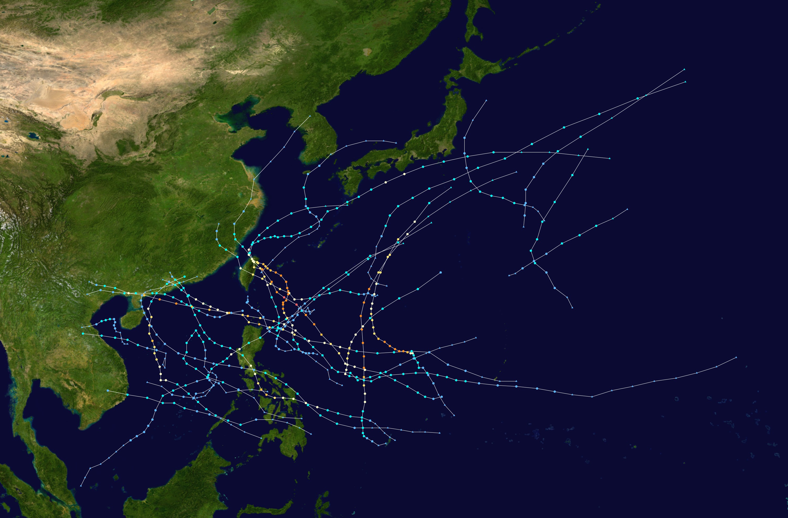
English: This map shows the tracks of all tropical cyclones in the 2008 Pacific typhoon season. The points show the location of each storm at 6-hour intervals. The colour represents the storm's maximum sustained wind speeds as classified in the Saffir-Simpson Hurricane Scale (see below), and the shape of the data points represent the type of the storm.
Tropical depression (≤38 mph, ≤62 km/h)
Tropical storm (39–73 mph, 63–118 km/h)
Category 1 (74–95 mph, 119–153 km/h)
Category 2 (96–110 mph, 154–177 km/h)
Category 3 (111–129 mph, 178–208 km/h)
Category 4 (130–156 mph, 209–251 km/h)
Category 5 (≥157 mph, ≥252 km/h)
Unknown
Storm type |
| Pinanggalingan | Created using Wikipedia:WikiProject Tropical cyclones/Tracks. The background image is from NASA [1]. The tracking data is from the Joint Typhoon Warning Center's best track database |
| May-akda | Potapych |

|
This file may be updated to reflect new information. If you wish to use a specific version of the file without new updates being mirrored, please upload the required version as a separate file. |
| Ang akdang ito ay pinakawalan sa sakop ng madla ng may-akda nito, si Potapych. Magagamit ito sa buong daigdig. Maaaring hindi ito posibleng legal sa ilang mga bansa; kung ganito: Ibinibigay ni Potapych kaninuman ang karapatang gamitin ang akdang ito para sa anumang layunin, na walang anumang kundisyon, maliban na lamang kung ang ganyang mga kundisyon ay kinakailangan sa batas. |
Nakaraan ng file
Pindutin ang araw/oras upang makita kung papaano ang itsura ng talaksan noong oras na iyon.
| Araw/Oras | Thumbnail | Mga dimensiyon | tagagamit | Kumento | |
|---|---|---|---|---|---|
| ngayon | 21:55, 17 Abril 2009 | | 3,000 × 1,974 (698 KB) | Potapych | {{PD-user|Potapych}} * Background image from NASA * Position of dots from [http://metocph.nmci.navy.mil/jtwc/best_tracks/ JTWC] Category:Pacific typhoon season track maps [[Category:2008 Pacific typhoon se |
Mga ugnay
Walang mga pahina ang tumuturo sa talaksang ito.
Pandaigdigang paggamit sa file
Ginagamit ng mga sumusunod na wiki ang file na ito:
- Paggamit sa ko.wikipedia.org
- Paggamit sa th.wikipedia.org