
Talaksan:2016 Pacific typhoon season summary.png
Laki ng pasilip na ito: 800 x 600 na pixel. Ibang mga resolusyon: 320 x 240 na pixel | 640 x 480 na pixel | 1,024 x 768 na pixel | 1,280 x 960 na pixel | 2,560 x 1,920 na pixel | 4,000 x 3,000 na pixel.
Buong resolusyon ((4,000 × 3,000 pixel, laki ng talaksan: 7.7 MB, uri ng MIME: image/png))
|
|
Ito ay isang talaksan mula sa Wikimedia Commons. Makikita sa ibaba ang impormasyon mula sa pahina ng paglalarawan nito roon. |
Buod
| Paglalarawan |
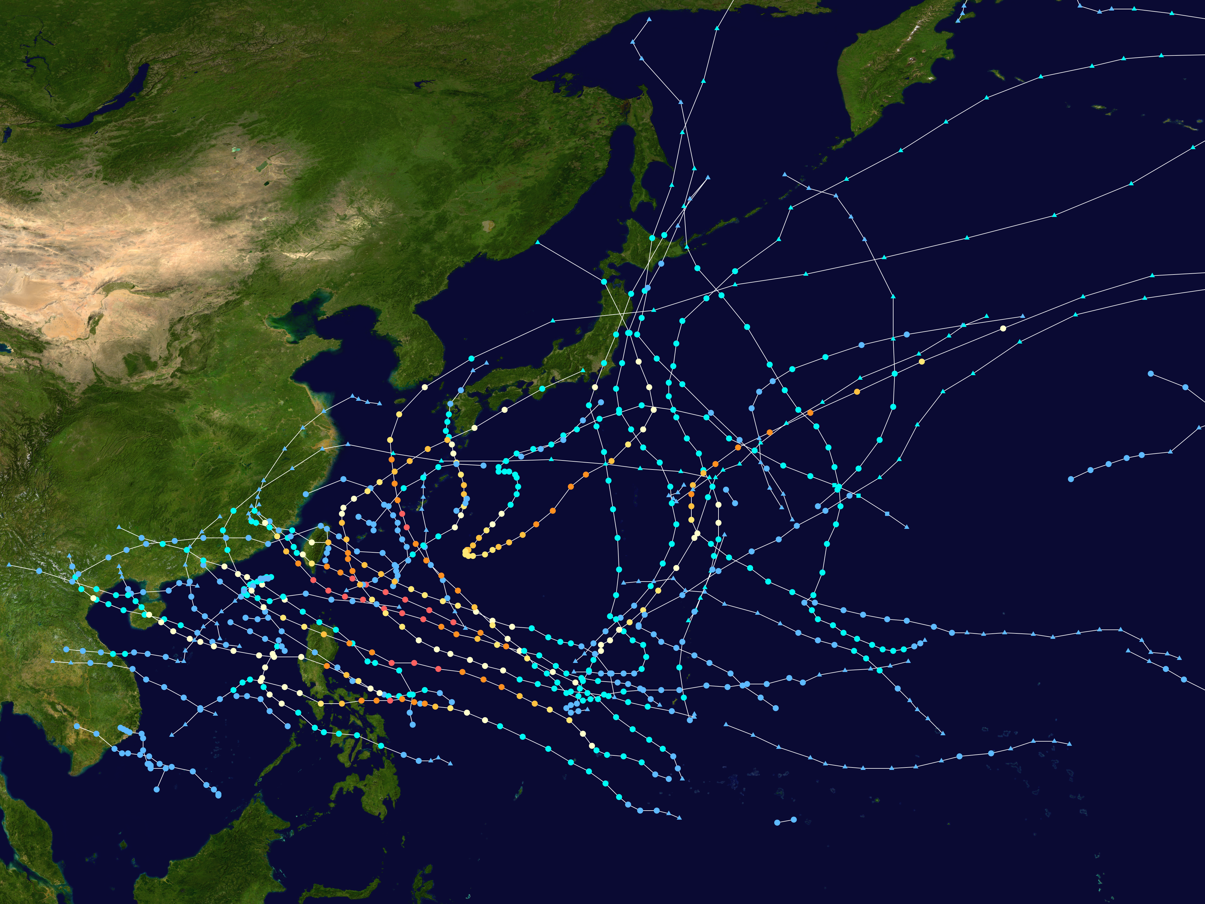
English: This map shows the tracks of all tropical cyclones in the 2016 Pacific typhoon season. The points show the location of each storm at 6-hour intervals. The colour represents the storm's maximum sustained wind speeds as classified in the Saffir-Simpson Hurricane Scale (see below), and the shape of the data points represent the type of the storm.
Tropical depression (≤38 mph, ≤62 km/h)
Tropical storm (39–73 mph, 63–118 km/h)
Category 1 (74–95 mph, 119–153 km/h)
Category 2 (96–110 mph, 154–177 km/h)
Category 3 (111–129 mph, 178–208 km/h)
Category 4 (130–156 mph, 209–251 km/h)
Category 5 (≥157 mph, ≥252 km/h)
Unknown
Storm type |
| Pinanggalingan | Created using Wikipedia:WikiProject Tropical cyclones/Tracks. The background image is from NASA [1]. The tracking data is from the Joint Typhoon Warning Center's best track database |
| May-akda | Supportstorm |
| Ang akdang ito ay pinakawalan sa sakop ng madla ng may-akda nito, si Supportstorm. Magagamit ito sa buong daigdig. Maaaring hindi ito posibleng legal sa ilang mga bansa; kung ganito: Ibinibigay ni Supportstorm kaninuman ang karapatang gamitin ang akdang ito para sa anumang layunin, na walang anumang kundisyon, maliban na lamang kung ang ganyang mga kundisyon ay kinakailangan sa batas. |
Nakaraan ng file
Pindutin ang araw/oras upang makita kung papaano ang itsura ng talaksan noong oras na iyon.
| Araw/Oras | Thumbnail | Mga dimensiyon | tagagamit | Kumento | |
|---|---|---|---|---|---|
| ngayon | 02:50, 16 Pebrero 2020 | | 4,000 × 3,000 (7.7 MB) | Supportstorm | Primarily JTWC/JMA data |
| 05:29, 9 Disyembre 2018 |  | 4,000 × 3,400 (10.42 MB) | Supportstorm | Reverted to version as of 05:01, 16 March 2018 (UTC) | |
| 16:23, 30 Agosto 2018 |  | 4,000 × 3,000 (9.98 MB) | David Petrovsky | Added also features known as the dimensions and size | |
| 05:01, 16 Marso 2018 |  | 4,000 × 3,400 (10.42 MB) | Supportstorm | Best track update | |
| 06:45, 14 Mayo 2017 |  | 4,000 × 2,942 (8.26 MB) | Supportstorm | Reverted to version as of 21:26, 22 February 2017 (UTC) | |
| 03:22, 28 Abril 2017 |  | 4,000 × 3,375 (10.3 MB) | Morgan Siu | ||
| 21:26, 22 Pebrero 2017 |  | 4,000 × 2,942 (8.26 MB) | Supportstorm | Update (JMA weather map reanalysis up to October 31) | |
| 09:17, 23 Disyembre 2016 |  | 4,000 × 3,375 (10.3 MB) | Supportstorm | Update (JMA weather map reanalysis up to August 31) | |
| 13:43, 15 Nobyembre 2016 |  | 4,000 × 3,375 (10.26 MB) | Supportstorm | Update | |
| 01:19, 30 Oktubre 2016 |  | 4,000 × 3,375 (10.14 MB) | Supportstorm | Update |
Mga ugnay
Nakaturo sa talaksan na ito ang mga sumusunod na mga pahina:
Pandaigdigang paggamit sa file
Ginagamit ng mga sumusunod na wiki ang file na ito:
- Paggamit sa bcl.wikipedia.org
- Paggamit sa de.wikipedia.org
- Paggamit sa en.wikipedia.org
- 2016 Pacific typhoon season
- Timeline of the 2016 Pacific typhoon season
- Template:2016 Pacific typhoon season buttons
- Typhoon Nepartak
- Tropical Storm Mirinae (2016)
- Tropical Storm Nida (2016)
- Tropical Storm Dianmu (2016)
- Typhoon Mindulle (2016)
- Typhoon Lionrock
- User:Nino Marakot/2016 Pacific typhoon season
- Typhoon Meranti
- Typhoon Malakas (2016)
- Tropical Storm Rai (2016)
- Typhoon Megi (2016)
- Typhoon Chaba (2016)
- Typhoon Songda (2016)
- Typhoon Sarika
- Typhoon Haima
- November 2016 Vietnam tropical depression
- Tropical Storm Aere (2016)
- User:Typhoon2013/PTS Format 1A
- Typhoon Nock-ten
- User:Tfmbty/2016 Pacific typhoon season
- Tropical cyclones in 2016
- User:HUYTK21
- Paggamit sa es.wikipedia.org
- Paggamit sa ja.wikipedia.org
- Paggamit sa ko.wikipedia.org
- Paggamit sa pt.wikipedia.org
- Paggamit sa th.wikipedia.org
- Paggamit sa vi.wikipedia.org
- Paggamit sa www.wikidata.org
- Paggamit sa zh-yue.wikipedia.org
- Paggamit sa zh.wikipedia.org
Tingnan ang karagdagang pandaigdigang paggamit sa file na ito.