
Talaksan:75967 South-China-Sea-1.jpg

Laki ng pasilip na ito: 800 x 557 na pixel. Ibang mga resolusyon: 320 x 223 na pixel | 640 x 445 na pixel | 1,024 x 713 na pixel | 1,280 x 891 na pixel | 2,560 x 1,782 na pixel | 9,570 x 6,660 na pixel.
Buong resolusyon ((9,570 × 6,660 pixel, laki ng talaksan: 30.8 MB, uri ng MIME: image/jpeg))
|
|
Ito ay isang talaksan mula sa Wikimedia Commons. Makikita sa ibaba ang impormasyon mula sa pahina ng paglalarawan nito roon. |
Buod
| Paglalarawan |
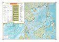
English: maps of the South China Sea with international disputes. 803425AI (G02257) 1-10 |
| Petsa | |
| Pinanggalingan |
This file was derived from: 75967 South-China-Sea-1.pdf:  |
| May-akda | Office of the Geographer, US Department of State, US Government |
| Iba pang mga bersyon |
|
.jpg)

| This is a retouched picture, which means that it has been digitally altered from its original version. Modifications: Bild ins JGEG–Format konvertiert; Bild auf das 8-fache vergrößert und daraus resultierende Artefakte verringert; Photoshop Speicheroptionen: Qualität 12. Modifications made by MagentaGreen.
|
Paglilisensiya
This work is in the public domain in the United States because it is a work prepared by an officer or employee of the United States Government as part of that person’s official duties under the terms of Title 17, Chapter 1, Section 105 of the US Code.
Note: This only applies to original works of the Federal Government and not to the work of any individual U.S. state, territory, commonwealth, county, municipality, or any other subdivision. This template also does not apply to postage stamp designs published by the United States Postal Service since 1978. (See § 313.6(C)(1) of Compendium of U.S. Copyright Office Practices). It also does not apply to certain US coins; see The US Mint Terms of Use.
|
 | |
| Nakilala ang talaksan bilang malaya mula sa nalalamang mga paghahangga sa ilalim ng batas sa karapatang-ari, kasama ang lahat ng mga kaugnay at karatig na mga karapatan. | ||
Nakaraan ng file
Pindutin ang araw/oras upang makita kung papaano ang itsura ng talaksan noong oras na iyon.
| Araw/Oras | Thumbnail | Mga dimensiyon | tagagamit | Kumento | |
|---|---|---|---|---|---|
| ngayon | 15:54, 10 Hulyo 2018 | | 9,570 × 6,660 (30.8 MB) | MagentaGreen | =={{int:filedesc}}== {{Information |description={{en|1=maps of the South China Sea with international disputes. 803425AI (G02257) 1-10}} |date=2010-01 |source={{Derived from|75967 South-China-Sea-1.pdf|display=100}} |author=Office of the Geographer, US Department of State, US Government |permission= |other versions= }} {{RetouchedPicture|Bild ins JGEG–Format konvertiert; Bild auf das 8-fache vergrößert und daraus resultierende Artefakte verringert; Photoshop Speicheroptionen: Qualität 12|edi... |
Mga ugnay
Nakaturo sa talaksan na ito ang mga sumusunod na mga pahina:
Pandaigdigang paggamit sa file
Ginagamit ng mga sumusunod na wiki ang file na ito:
- Paggamit sa de.wikipedia.org
- Paggamit sa lt.wikipedia.org
- Paggamit sa uk.wikipedia.org