
Talaksan:American Black bear map.png
Walang resolusyong mataas.
American_Black_bear_map.png ((515 × 599 pixel, laki ng talaksan: 95 KB, uri ng MIME: image/png))
|
|
Ito ay isang talaksan mula sa Wikimedia Commons. Makikita sa ibaba ang impormasyon mula sa pahina ng paglalarawan nito roon. |
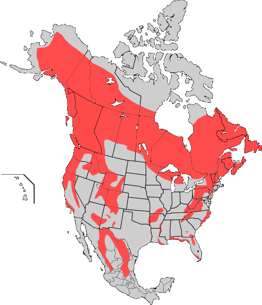
| Paglalarawan | Range map of the American Black Bear (Ursus Americanus) updated, see: http://blogs.courierpostonline.com/fishhead/files/2008/12/beardist.jpg http://www.nps.gov/shen/naturescience/images/va_dgif_bear_map_556.jpg http://www.dec.ny.gov/images/wildlife_images/bearngexp9507.jpg http://www.ncwildlife.org/Wildlife_Species_Con/images/bear_dist_map.pdf. Includes state and province borders, as well as Hawaii. |
| Petsa | (UTC) |
| Pinanggalingan | |
| May-akda |
|
| This is a retouched picture, which means that it has been digitally altered from its original version. Modifications: whiten. The original can be viewed here: Black bear map.png:
|
Ako, na may karapatang-ari ng akdang ito, ang naglalathala nito alinsunod sa ilalim ng sumusunod na mga lisensya:
Lisensyado ang file na ito sa ilalim ng lisensiyang Creative Commons Attribution-Share Alike 3.0 Unported.
- Malaya kang:
- para ibahagi – para kopyahin, ipamahagi, at i-transmit ang akda
- para i-remix – para i-adapt ang akda
- Sa ilalim ng mga kondisyong ito:
- atribusyon – Dapat magbigay ka ng isang maayos na pag-credit, ibigay ang link sa lisensiya, at tukuyin kung may mga pagbabagong ginawa. Magagawa mo ito sa isang risonableng paraan, pero hindi sa paraan na para bang ineendorso ka o ng paggamit mo ng naglisensiya sa'yo.
- share alike – Kung ire-remix mo, babaguhin, o magdadagdag ka sa materyal, dapat mong ipamahagi ang mga ambag mo sa ilalim ng pareho o katulad na lisensiya.
Tala ng orihinal na pagkarga
This image is a derivative work of the following images:
- File:Black_bear_map.png licensed with Cc-by-sa-3.0
- 2010-03-09T18:58:18Z Bobisbob 515x599 (79012 Bytes) {{Information |Description=Range map of the American Black Bear (Ursus Americanus) |Source=*[[:File:Map_Black_Bear.svg|]] |Date=2010-03-09 18:56 (UTC) |Author=*[[:File:Map_Black_Bear.svg|]]: [[User:Kmusser|Kmusser]] *derivati
Uploaded with derivativeFX
Nakaraan ng file
Pindutin ang araw/oras upang makita kung papaano ang itsura ng talaksan noong oras na iyon.
| Araw/Oras | Thumbnail | Mga dimensiyon | tagagamit | Kumento | |
|---|---|---|---|---|---|
| ngayon | 02:09, 22 Marso 2010 | | 515 × 599 (95 KB) | Bobisbob~commonswiki | {{Information |Description=Range map of the American Black Bear (Ursus Americanus) updated, see: http://blogs.courierpostonline.com/fishhead/files/2008/12/beardist.jpg http://www.nps.gov/shen/naturescience/images/va_dgif_bear_map_556.jpg http://www.dec.ny |
Mga ugnay
Walang mga pahina ang tumuturo sa talaksang ito.
Pandaigdigang paggamit sa file
Ginagamit ng mga sumusunod na wiki ang file na ito:
- Paggamit sa ar.wikipedia.org
- Paggamit sa arz.wikipedia.org
- Paggamit sa ban.wikipedia.org
- Paggamit sa bg.wikipedia.org
- Paggamit sa ca.wikipedia.org
- Paggamit sa eu.wikipedia.org
- Paggamit sa ga.wikipedia.org
- Paggamit sa incubator.wikimedia.org
- Paggamit sa kab.wikipedia.org
- Paggamit sa nl.wikipedia.org
- Paggamit sa nn.wikipedia.org
- Paggamit sa ro.wikipedia.org
- Paggamit sa www.wikidata.org