
Talaksan:Ancient near east 540 bc.svg

Size of this PNG preview of this SVG file: 800 x 444 na pixel. Ibang mga resolusyon: 320 x 178 na pixel | 640 x 355 na pixel | 1,024 x 568 na pixel | 1,280 x 710 na pixel | 2,560 x 1,420 na pixel | 1,249 x 693 na pixel.
Buong resolusyon ((Larawang SVG, tinatayang 1,249 × 693 mga pixel, laki ng talakasan: 263 KB))
|
|
Ito ay isang talaksan mula sa Wikimedia Commons. Makikita sa ibaba ang impormasyon mula sa pahina ng paglalarawan nito roon. |
Buod
| Paglalarawan |
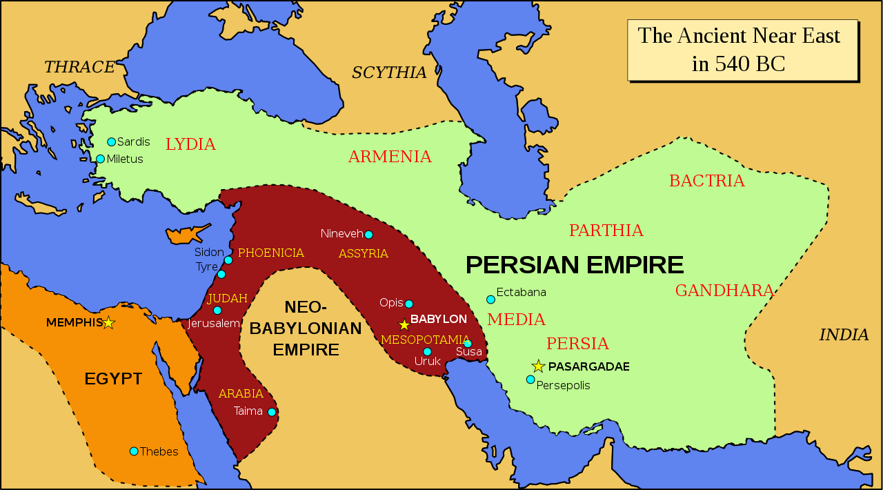
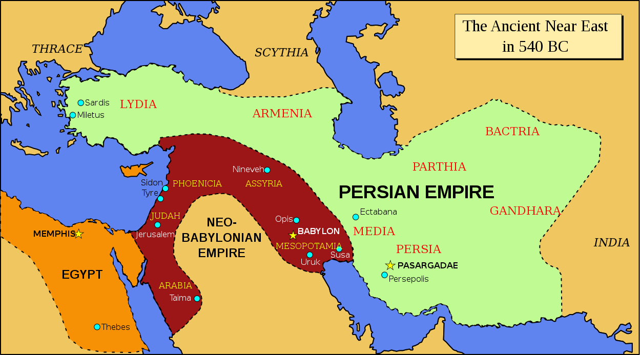
English: Map of the ancient Near East in 540 BC |
| Petsa | |
| Pinanggalingan | Derived from Image:Oriente Medio 600 adC (vacío).svg; modified to follow the map of the Achemenid empire of Persia - 559-480 BC in the Concise Atlas of World History (Andromeda, 1997). |
| May-akda | ChrisO |
.svg)
Paglilisensiya
| Ako, ang may tangan ng karapatang-ari ng akdang ito, ay pinakakawalan ang akdang ito sa nasasakupan ng madla. Magagamit ito sa buong mundo. Maaaring hindi ito posibleng legal sa ilang mga bansa; kung ganito: Ibinibigay ko sa sinuman ang karapatang gamitin ang akdang ito para sa anumang layunin, na walang mga kundisyon, maliban na lang kung ang ganyang mga kundisyon ay kailangan ng batas. |
Nakaraan ng file
Pindutin ang araw/oras upang makita kung papaano ang itsura ng talaksan noong oras na iyon.
| Araw/Oras | Thumbnail | Mga dimensiyon | tagagamit | Kumento | |
|---|---|---|---|---|---|
| ngayon | 12:36, 3 Setyembre 2021 | | 1,249 × 693 (263 KB) | Darafsh | File uploaded using svgtranslate tool (https://svgtranslate.toolforge.org/). Added translation for fa. |
| 20:14, 25 Oktubre 2008 |  | 1,249 × 693 (245 KB) | ChrisO | ||
| 19:55, 25 Oktubre 2008 |  | 1,249 × 693 (245 KB) | ChrisO | ||
| 18:17, 25 Oktubre 2008 |  | 1,249 × 693 (244 KB) | ChrisO | ||
| 18:14, 25 Oktubre 2008 |  | 1,249 × 693 (244 KB) | ChrisO | ||
| 18:13, 25 Oktubre 2008 |  | 1,249 × 693 (244 KB) | ChrisO | ||
| 20:53, 24 Oktubre 2008 |  | 1,249 × 693 (243 KB) | ChrisO | Category:Maps of the ancient Near East | |
| 20:52, 24 Oktubre 2008 |  | 1,249 × 693 (244 KB) | ChrisO | Category:Maps of the ancient Near East | |
| 20:48, 24 Oktubre 2008 |  | 1,249 × 693 (243 KB) | ChrisO | {{Information |Description={{en|1=Map of the ancient Near East in 540 BC}} |Source=Derived from Image:Oriente Medio 600 adC (vacío).svg |Author=ChrisO |Date=24 October 2008 |Permission= |other_versions= }} <!--{{ImageUpload|full}}-- |
.svg)
Mga ugnay
Nakaturo sa talaksan na ito ang mga sumusunod na mga pahina:
Pandaigdigang paggamit sa file
Ginagamit ng mga sumusunod na wiki ang file na ito:
- Paggamit sa ar.wikipedia.org
- Paggamit sa azb.wikipedia.org
- Paggamit sa bg.wikipedia.org
- Paggamit sa ca.wikipedia.org
- Paggamit sa en.wikipedia.org
- Paggamit sa fa.wikipedia.org
- Paggamit sa fr.wikipedia.org
- Paggamit sa hr.wikipedia.org
- Paggamit sa it.wikipedia.org
- Paggamit sa ja.wikipedia.org
- Paggamit sa no.wikipedia.org
- Paggamit sa pt.wikipedia.org
- Paggamit sa ru.wikipedia.org
- Paggamit sa sh.wikipedia.org
- Paggamit sa sr.wikipedia.org
- Paggamit sa th.wikipedia.org
- Paggamit sa tr.wikipedia.org
- Paggamit sa www.wikidata.org