
Talaksan:Aztec Empire 1519 map-fr.svg

Size of this PNG preview of this SVG file: 778 x 599 na pixel. Ibang mga resolusyon: 312 x 240 na pixel | 623 x 480 na pixel | 997 x 768 na pixel | 1,280 x 986 na pixel | 2,560 x 1,972 na pixel | 1,898 x 1,462 na pixel.
Buong resolusyon ((Larawang SVG, tinatayang 1,898 × 1,462 mga pixel, laki ng talakasan: 303 KB))
|
|
Ito ay isang talaksan mula sa Wikimedia Commons. Makikita sa ibaba ang impormasyon mula sa pahina ng paglalarawan nito roon. |
Buod
| Paglalarawan |
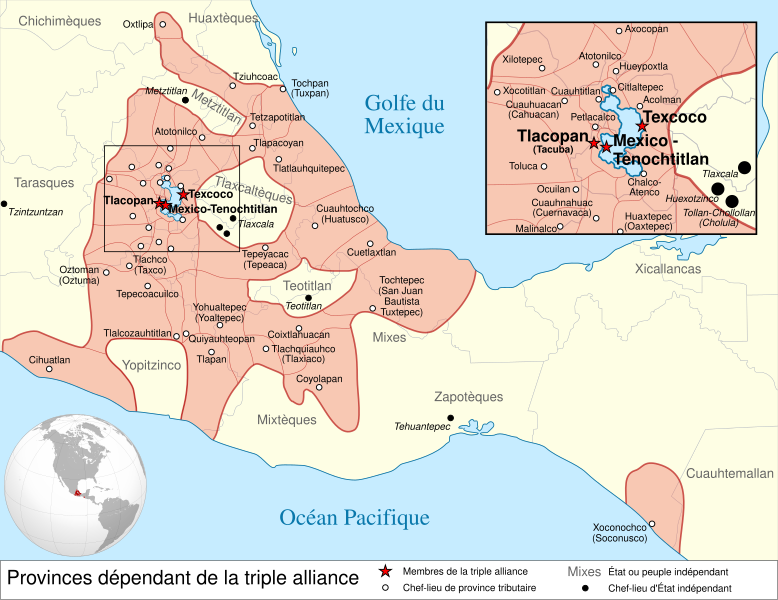
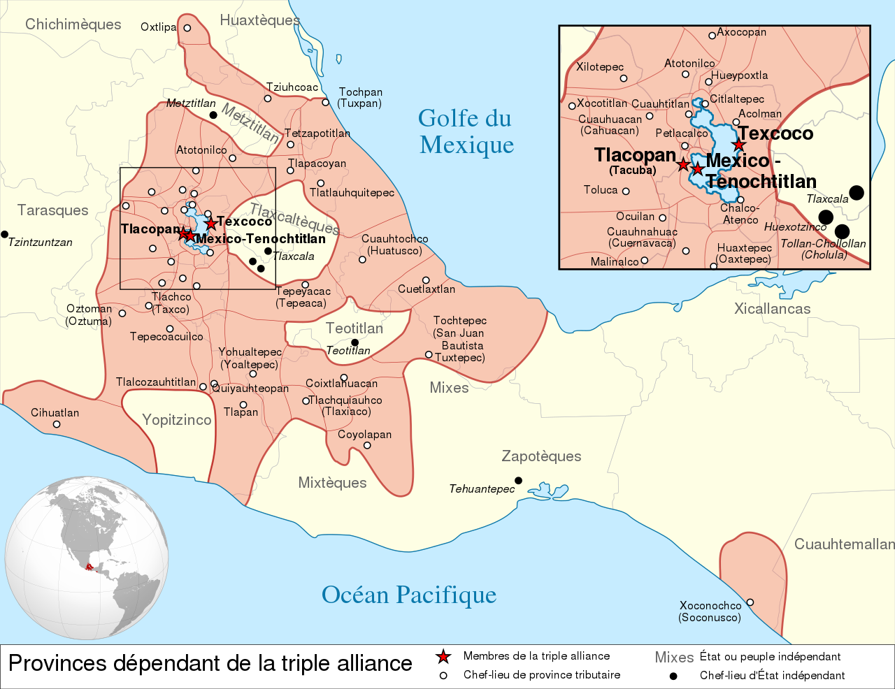
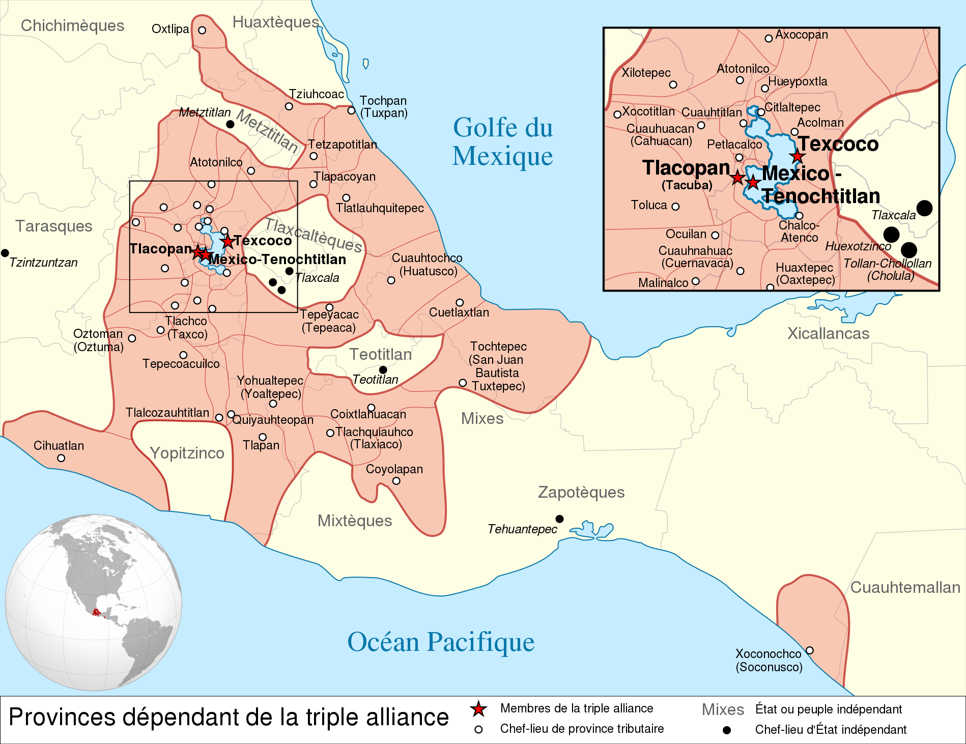
Español: Provincias tributarias de la Triple Alianza encabezada por Tenochtitlan antes de la llegada de los españoles en 1519.
English: Map of the Aztec Empire lead by Tenochtitlan circa 1519, before the arrival of the Spanish.
Français : Étendue de l'empire Aztèque soumis à la Triple Alliance, dirigée par Tenochtitlan, à l'arrivée des Espagnols en 1519. |
| Petsa | (UTC) |
| Pinanggalingan |
|
| May-akda | |
| Iba pang mga bersyon |
[] Detailed maps
Simple maps
|


.svg)
.svg)
.svg)
| Camera location | | View this and other nearby images on: OpenStreetMap |
|---|

|
This SVG file contains embedded text that can be translated into your language, using any capable SVG editor, text editor or the SVG Translate tool. For more information see: About translating SVG files. |
This W3C-unspecified vector image was created with Inkscape .
Paglilisensiya
Lisensyado ang file na ito sa ilalim ng lisensiyang Creative Commons Attribution-Share Alike 3.0 Unported.
- Malaya kang:
- para ibahagi – para kopyahin, ipamahagi, at i-transmit ang akda
- para i-remix – para i-adapt ang akda
- Sa ilalim ng mga kondisyong ito:
- atribusyon – Dapat magbigay ka ng isang maayos na pag-credit, ibigay ang link sa lisensiya, at tukuyin kung may mga pagbabagong ginawa. Magagawa mo ito sa isang risonableng paraan, pero hindi sa paraan na para bang ineendorso ka o ng paggamit mo ng naglisensiya sa'yo.
- share alike – Kung ire-remix mo, babaguhin, o magdadagdag ka sa materyal, dapat mong ipamahagi ang mga ambag mo sa ilalim ng pareho o katulad na lisensiya.
Tala ng orihinal na pagkarga
This image is a derivative work of the following images:
- File:Provincias_tributarias_de_la_Triple_Alianza_(s._XVI).svg licensed with Cc-by-sa-3.0-migrated, FAL, GFDL
- 2008-12-13T03:29:16Z Yavidaxiu 949x731 (878329 Bytes) {{Information |Description={{es|1=Provincias tributarias de la Triple Alianza encabezada por Tenochtitlan antes de la llegada de los españoles. Fuente: ''Atlas del México prehispánico'', edición especial de ''Arqueología
- File:Aztec_Empire_(orthographic_projection).svg licensed with Cc-by-sa-3.0, GFDL
- 2010-02-11T12:23:41Z Sémhur 550x550 (104628 Bytes) Update with data from a sourced map.
- 2010-01-10T20:34:52Z Keepscases 550x550 (284361 Bytes) {{Information |Description={{en|1=Aztec Empire (orthographic projection)}} |Source={{own}} |Author=[[User:Keepscases|Keepscases]] |Date= |Permission= |other_versions= }} [[Category:SVG - Orthographic projections]]
Uploaded with derivativeFX
Nakaraan ng file
Pindutin ang araw/oras upang makita kung papaano ang itsura ng talaksan noong oras na iyon.
| Araw/Oras | Thumbnail | Mga dimensiyon | tagagamit | Kumento | |
|---|---|---|---|---|---|
| ngayon | 15:01, 23 Marso 2010 | | 1,898 × 1,462 (303 KB) | El Comandante | État tarasque->Tarasques + Royaumes mixtèques->Mixtèques + Correction du positionnement de 2 textes |
| 17:58, 7 Marso 2010 |  | 1,898 × 1,462 (303 KB) | El Comandante | More readable fonts | |
| 18:06, 25 Pebrero 2010 |  | 1,898 × 1,462 (306 KB) | Sémhur | Font : Nimbus Sans L | |
| 17:29, 24 Pebrero 2010 |  | 949 × 731 (305 KB) | Sémhur | 2 - Encart de la région centrale | |
| 12:55, 11 Pebrero 2010 |  | 949 × 731 (262 KB) | Sémhur | == {{int:filedesc}} == {{Information |Description={{es|1=Provincias tributarias de la Triple Alianza encabezada por Tenochtitlan antes de la llegada de los españoles en 1519.}} {{en|1=Map of the [[:en:Aztec Empire[Aztec Empire]] lead by Tenochtitlan circ |
Mga ugnay
Walang mga pahina ang tumuturo sa talaksang ito.
Pandaigdigang paggamit sa file
Ginagamit ng mga sumusunod na wiki ang file na ito:
- Paggamit sa af.wikipedia.org
- Paggamit sa ar.wikipedia.org
- Paggamit sa azb.wikipedia.org
- Paggamit sa br.wikipedia.org
- Paggamit sa el.wikipedia.org
- Paggamit sa en.wikipedia.org
- Aztecs
- List of conflicts in North America
- Aztec Empire
- Wikipedia:WikiProject Aztec/Backup 2006-07-17
- Tlaxcala (Nahua state)
- Aztec architecture
- User:Maunus/sandbox
- Template:Aztec
- List of conflicts in Mexico
- User:Bobo.03/sandbox
- User:Tisquesusa/sandbox9
- Xihuitl Temoc
- User:SomeGuyWhoRandomlyEdits/List of conflicts in Mexico
- Talk:Aztec Empire/Archive 1
- Paggamit sa en.wikibooks.org
- Paggamit sa fi.wikipedia.org
- Paggamit sa fr.wikipedia.org
- Paggamit sa hy.wikipedia.org
- Paggamit sa id.wikipedia.org
- Paggamit sa id.wikibooks.org
- Paggamit sa it.wikipedia.org
Tingnan ang karagdagang pandaigdigang paggamit sa file na ito.