
Talaksan:Bairisches Mundartgebiet.PNG
Buong resolusyon ((1,031 × 651 pixel, laki ng talaksan: 43 KB, uri ng MIME: image/png))
|
|
Ito ay isang talaksan mula sa Wikimedia Commons. Makikita sa ibaba ang impormasyon mula sa pahina ng paglalarawan nito roon. |

|
This linguistic map image could be re-created using vector graphics as an SVG file. This has several advantages; see Commons:Media for cleanup for more information. If an SVG form of this image is available, please upload it and afterwards replace this template with
{{vector version available|new image name}}.
It is recommended to name the SVG file “Bairisches Mundartgebiet.svg”—then the template Vector version available (or Vva) does not need the new image name parameter. |
Buod
- design by: Postmann Michael
- Quelle: Selbst erstellt.
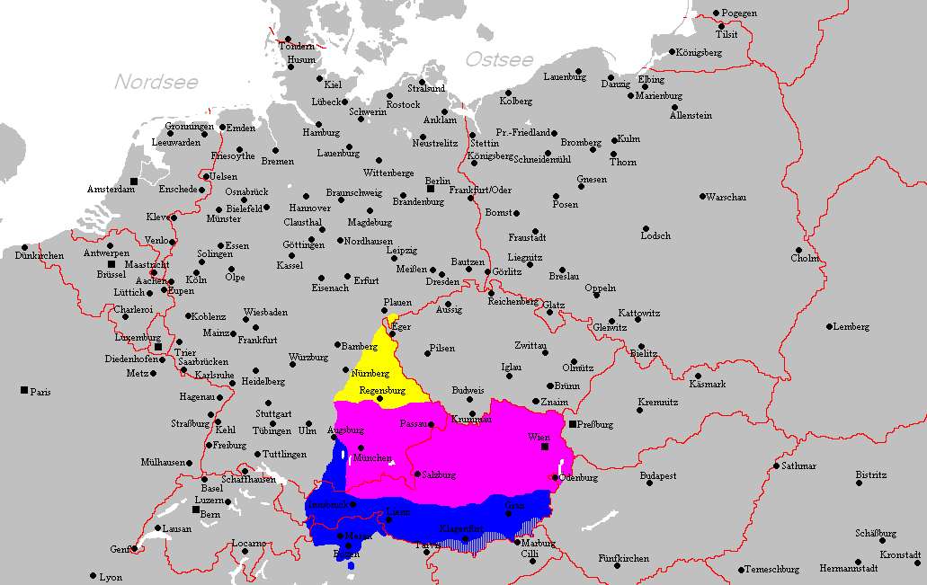
- Hinweis: Nach den Vorgaben des "Der Fischer-Informationsatlas der Bundesrepublik Deutschland" (ISBN 3-596-24556-4 Invalid ISBN) von 1990 (S. 63) selbst erstellt. Es wurde sowohl die Karte Westmitteleuropas als auch das bayrische Sprachgebiet vom Autor händisch erstellt. Diese Karte ist gemeinfrei und darf von jedermann verwendet werden!
- Source: Self-made.
- Notes: Information derived from "The Fischer Information Atlas of the Federal Republic of Germany" (ISBN 3-596-24556-4 Invalid ISBN) from 1990 (P. 63). Both the map of west Central Europe and the Bavarian language area were by hand provided by the author. This map is in the public domain and may be used by everyone!
Paglilisensiya
| Ang akdang ito ay pinakawalan sa sakop ng madla ng may-akda nito, si Postmann Michael. Magagamit ito sa buong daigdig. Maaaring hindi ito posibleng legal sa ilang mga bansa; kung ganito: |
Nakaraan ng file
Pindutin ang araw/oras upang makita kung papaano ang itsura ng talaksan noong oras na iyon.
| Araw/Oras | Thumbnail | Mga dimensiyon | tagagamit | Kumento | |
|---|---|---|---|---|---|
| ngayon | 21:22, 18 Pebrero 2012 | | 1,031 × 651 (43 KB) | Buachamer | Sechsämterland und Südvogtland hinzugefügt (siehe http://bar.wikipedia.org/wiki/Datei:Bairischer_Sprachraum2.PNG) |
| 17:56, 12 Abril 2009 |  | 1,031 × 651 (57 KB) | Altaileopard | Nürnberg aus dem bayerischen Dialektraum entfernt. | |
| 04:10, 2 Marso 2006 |  | 1,031 × 651 (57 KB) | Postmann Michael~commonswiki |
Mga ugnay
Nakaturo sa talaksan na ito ang mga sumusunod na mga pahina:
Pandaigdigang paggamit sa file
Ginagamit ng mga sumusunod na wiki ang file na ito:
- Paggamit sa als.wikipedia.org
- Paggamit sa ar.wikipedia.org
- Paggamit sa ast.wikipedia.org
- Paggamit sa be-tarask.wikipedia.org
- Paggamit sa be.wikipedia.org
- Paggamit sa bg.wikipedia.org
- Paggamit sa br.wikipedia.org
- Paggamit sa ca.wikipedia.org
- Paggamit sa cs.wikipedia.org
- Paggamit sa da.wikipedia.org
- Paggamit sa de.wikipedia.org
- Paggamit sa de.wiktionary.org
- Paggamit sa en.wikipedia.org
- Paggamit sa es.wikipedia.org
- Paggamit sa et.wikipedia.org
- Paggamit sa eu.wikipedia.org
- Paggamit sa fa.wikipedia.org
- Paggamit sa fr.wikipedia.org
- Paggamit sa fy.wikipedia.org
- Paggamit sa ga.wikipedia.org
- Paggamit sa hak.wikipedia.org
- Paggamit sa he.wikipedia.org
- Paggamit sa id.wikipedia.org
- Paggamit sa incubator.wikimedia.org
- Paggamit sa it.wikipedia.org
Tingnan ang karagdagang pandaigdigang paggamit sa file na ito.