
Talaksan:Bhutan CIA WFB 2010 map.png
Walang resolusyong mataas.
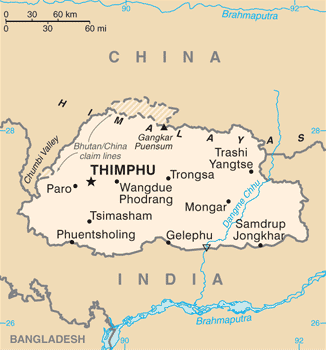
Bhutan_CIA_WFB_2010_map.png ((326 × 350 pixel, laki ng talaksan: 16 KB, uri ng MIME: image/png))
|
|
Ito ay isang talaksan mula sa Wikimedia Commons. Makikita sa ibaba ang impormasyon mula sa pahina ng paglalarawan nito roon. |

|
This map image could be re-created using vector graphics as an SVG file. This has several advantages; see Commons:Media for cleanup for more information. If an SVG form of this image is available, please upload it and afterwards replace this template with
{{vector version available|new image name}}.
It is recommended to name the SVG file “Bhutan CIA WFB 2010 map.svg”—then the template Vector version available (or Vva) does not need the new image name parameter. |
Buod
| Paglalarawan | Bhutan map from CIA World Factbook (since June 24, 2010) |
| Petsa | |
| Pinanggalingan |
CIA World Factbook, converted from original GIF format |
| May-akda | United States Central Intelligence Agency |
| Iba pang mga bersyon |
|
Paglilisensiya
This image is in the public domain because it contains materials that originally came from the United States Central Intelligence Agency's World Factbook.
|
 |
Nakaraan ng file
Pindutin ang araw/oras upang makita kung papaano ang itsura ng talaksan noong oras na iyon.
| Araw/Oras | Thumbnail | Mga dimensiyon | tagagamit | Kumento | |
|---|---|---|---|---|---|
| ngayon | 19:40, 6 Hulyo 2017 | | 326 × 350 (16 KB) | Ras67 | cropped, opt. |
| 11:56, 12 Mayo 2015 |  | 330 × 354 (52 KB) | Evolt | Updated to version as of April 24, 2015 | |
| 12:17, 22 Agosto 2011 |  | 330 × 354 (18 KB) | Zyxw | =={{int:filedesc}}== {{Information | Description = Bhutan map from CIA World Factbook ([http://web.archive.org/web/20100704230847/https://www.cia.gov/library/publications/the-world-factbook/geos/bt.html since June 24, 2010]) | Source = CIA World Factbook, |
Mga ugnay
Nakaturo sa talaksan na ito ang mga sumusunod na mga pahina:
Pandaigdigang paggamit sa file
Ginagamit ng mga sumusunod na wiki ang file na ito:
- Paggamit sa ace.wikipedia.org
- Paggamit sa af.wikipedia.org
- Paggamit sa als.wikipedia.org
- Paggamit sa ar.wikipedia.org
- Paggamit sa as.wikipedia.org
- Paggamit sa bcl.wikipedia.org
- Paggamit sa bh.wikipedia.org
- Paggamit sa bjn.wikipedia.org
- Paggamit sa bn.wikipedia.org
- Paggamit sa ca.wikipedia.org
- Paggamit sa cy.wikipedia.org
- Paggamit sa da.wikipedia.org
- Paggamit sa de.wikipedia.org
- Paggamit sa de.wiktionary.org
- Paggamit sa dv.wikipedia.org
- Paggamit sa dz.wikipedia.org
- Paggamit sa en.wikipedia.org
- Paggamit sa en.wiktionary.org
- Paggamit sa eo.wikipedia.org
- Paggamit sa es.wikipedia.org
- Paggamit sa eu.wikipedia.org
- Paggamit sa fa.wikipedia.org
- Paggamit sa fi.wikipedia.org
Tingnan ang karagdagang pandaigdigang paggamit sa file na ito.