Talaksan:Europe in 1345.png

Page contents not supported in other languages.
Mula sa Wikipedia, ang malayang ensiklopedya

Buong resolusyon((1,075 × 1,168 pixel, laki ng talaksan: 114 KB, uri ng MIME: image/png))

Buod

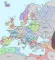
Paglalarawan A map of Europe in 1345, showing the location of events that took place in that year. The Black Plague's exact location in unknown, and the shaded area to the right represents rough scholarly estimates. It hit the Crimea in the following year.
Petsa
Pinanggalingan self-made from Image:Europein1328.png with GIMP
May-akda Teaandcrumpets
This historical map image could be re-created using vector graphics as an SVG file. This has several advantages; see Commons:Media for cleanup for more information. If an SVG form of this image is available, please upload it and afterwards replace this template with {{vector version available|new image name}}.


It is recommended to name the SVG file “Europe in 1345.svg”—then the template Vector version available (or Vva) does not need the new image name parameter.
Maps of the history of Europe
BCE
aC

Weichselian ice age (c. 113,000–9700) · Neolithic expansion (c. 7000–4500) · Middle Neolithic (c. 4500–4000) · Late Neolithic (c. 4000–3000) · Copper Age – Corded Ware culture (c. 2900–2350) · Copper Age – Bellbeaker culture (c. 2800–1800) · Early Bronze Age – Unetice culture (c. 2300–1600) · Late Bronze Age – Urnfield culture (c. 1300—750) · Migrations (c. 1000–100) · Hallstatt & La Tène cultures (c. 800–100) · Roman Republic (510–40) · 220 · 218 · 200 · 201–100 · 58 · 49 · 39 · 30 BCE–6 CE


CE
dC

14 · 14–37 · 60 · 60 · 69 · 80 · Migrations 100–500 · 117 · 117 · 125 · Migrations 150–774 · Economy 180 · 271 · 293–305 · 337 · 395 · c. 395 · 400 · 400 · 450 · 457–61 · 476 · 480 · Franks 481–814 · Early Slavs 500–700 · 500 · 526 · 526–600 · Christianisation to 600 · c. 550 · 650 · Pontic Steppe 650 · 665 · 800 · Vikings 800–1050 · 814 · 843–70 · 850 · 900 · 912 · 998 · 1000 · 1000 · 1054 · 1092 · First Crusade 1095–99 · 1097 · 1135 · 1142 · 1147–49 · 1190 · 1190 · 1250 · c. 1250 · 1301-1400 · 1301-1400 · 1328 · 1345 · Black Plague 1347–51 · 1360 · 1400 · Trade routes c. 1400 · 1430 · 1470 · 1490 · 1492 · 1500 · 1519 · 1550 · 1560 · Religion 1560 · Religion 1600 · Religion 1618 · 1618–48 · 1648 · 1683 · 1700 · 1701 · 1708 · 1714 · 1721 · 1725–30 · 1739–1740 · 1740 · 1748–66 · 1783–1792 · 1787 · 1787 · 1789 · 1799 · 1812 · 1812 · 1812 · 1812 · 1813 · 1815 · 1815 · 1815 · 1818 · Ottoman Empire 1830–1923 · 1848–49 · 1861 · 1867 · 1871 · 1878 · 1890 · 1905 · 1911 · 1914 · 1914 · 1919 · 1919–29 · 1923 · 1929 · 1930 · 1940 · 1941–42 · 1942–45 · Cold War 1947–91 · 1950 · 1993–2006 · 2006 to date

(this template: · view · discuss )

Paglilisensiya

Public domain Ako, ang may tangan ng karapatang-ari ng akdang ito, ay pinakakawalan ang akdang ito sa nasasakupan ng madla. Magagamit ito sa buong mundo.
Maaaring hindi ito posibleng legal sa ilang mga bansa; kung ganito:
Ibinibigay ko sa sinuman ang karapatang gamitin ang akdang ito para sa anumang layunin, na walang mga kundisyon, maliban na lang kung ang ganyang mga kundisyon ay kailangan ng batas.

Captions

Add a one-line explanation of what this file represents

Items portrayed in this file

depicts English

13 Nobyembre 2007

Nakaraan ng file

Pindutin ang araw/oras upang makita kung papaano ang itsura ng talaksan noong oras na iyon.

Araw/OrasThumbnailMga dimensiyontagagamitKumento
ngayon19:31, 10 Mayo 2020Thumbnail para sa bersyon noong 19:31, 10 Mayo 20201,075 × 1,168 (114 KB)Santasa99Corrections per Euroatlas - Historical Maps, http://www.euratlas.net/history/europe/1300/index.html Euratlas Periodis Web - Map of Europe in Year 1300
12:58, 24 Disyembre 2017Thumbnail para sa bersyon noong 12:58, 24 Disyembre 20171,075 × 1,168 (289 KB)Trey KincaidChanged Sicily who had his own kingdom
19:30, 1 Hulyo 2012Thumbnail para sa bersyon noong 19:30, 1 Hulyo 20121,075 × 1,168 (282 KB)Ludde23Changed Estonia from the red color of Sweden to the yellow color of Denmark, since Estonia was not Swedish at this time, but belonged to Denmark until 1346.
21:34, 24 Abril 2009Thumbnail para sa bersyon noong 21:34, 24 Abril 20091,075 × 1,168 (112 KB)Alex:DBorders corrected
18:02, 15 Nobyembre 2007Thumbnail para sa bersyon noong 18:02, 15 Nobyembre 20071,075 × 1,168 (110 KB)Teaandcrumpets(changed notre dame marker)
23:03, 13 Nobyembre 2007Thumbnail para sa bersyon noong 23:03, 13 Nobyembre 20071,075 × 1,168 (113 KB)Teaandcrumpets{{Information |Description= A map of Europe in 1345, showing the location of events that took place in that year. |Source=self-made from Image:Europein1328.png with GIMP |Date= 13 Nov 2007 |Author= Teaandcrumpets |Permission=

Walang mga pahina ang tumuturo sa talaksang ito.

Pandaigdigang paggamit sa file

Ginagamit ng mga sumusunod na wiki ang file na ito:

Metadata