
Talaksan:Hurricane Fabian 02 sept 2003.jpg

Laki ng pasilip na ito: 458 x 599 na pixel. Ibang mga resolusyon: 183 x 240 na pixel | 367 x 480 na pixel | 587 x 768 na pixel | 783 x 1,024 na pixel | 1,566 x 2,048 na pixel | 5,200 x 6,800 na pixel.
Buong resolusyon ((5,200 × 6,800 pixel, laki ng talaksan: 5.19 MB, uri ng MIME: image/jpeg))
|
|
Ito ay isang talaksan mula sa Wikimedia Commons. Makikita sa ibaba ang impormasyon mula sa pahina ng paglalarawan nito roon. |
Buod
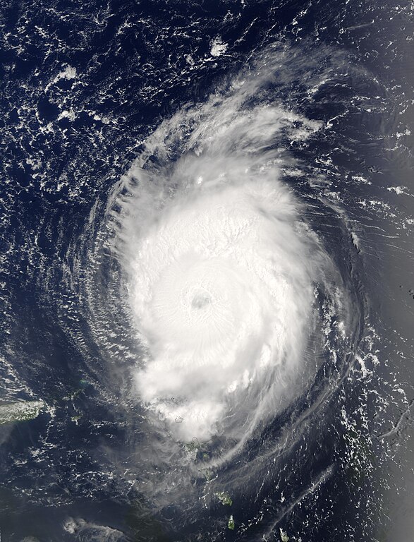
| Paglalarawan | The MODIS instrument onboard NASA's Terra spacecraft captured this bird's-eye view of Hurricane Fabian in the Atlantic Ocean. In this image Fabian is located about 190 miles north-northeast of Barbuda in the northern Leeward Islands. Fabian is a Category 4 storm on the Saffir-Simpson Scale and is packing sustained winds of 140 mph with higher gusts. The National Hurricane Center expects Fabian to continue on a west-northwest path at 10 mph for the next 24 hours. | |||||
| Petsa | ||||||
| Pinanggalingan | http://visibleearth.nasa.gov/view_rec.php?id=5736 | |||||
| May-akda | Jacques Descloitres, MODIS Rapid Response Team, NASA/GSFC | |||||
| Permiso (Muling paggamit sa file) |
|
|||||
| Iba pang mga bersyon | Image:Hurricane fabian 2003.jpg |

Nakaraan ng file
Pindutin ang araw/oras upang makita kung papaano ang itsura ng talaksan noong oras na iyon.
| Araw/Oras | Thumbnail | Mga dimensiyon | tagagamit | Kumento | |
|---|---|---|---|---|---|
| ngayon | 15:45, 29 Setyembre 2006 | | 5,200 × 6,800 (5.19 MB) | Good kitty | == Summary == {{Information |Description=The MODIS instrument onboard NASA's Terra spacecraft captured this bird's-eye view of Hurricane Fabian in the Atlantic Ocean. In this image Fabian is located about 190 miles north-northeast of Barbuda in the northe |
Mga ugnay
Nakaturo sa talaksan na ito ang mga sumusunod na mga pahina:
Pandaigdigang paggamit sa file
Ginagamit ng mga sumusunod na wiki ang file na ito:
- Paggamit sa ca.wikipedia.org
- Paggamit sa en.wikipedia.org
- Paggamit sa eo.wikipedia.org
- Paggamit sa fr.wikipedia.org
- Paggamit sa simple.wikipedia.org
- Paggamit sa www.wikidata.org
- Paggamit sa zh.wikipedia.org