
Talaksan:Koror, Caroline Islands city graphic.jpg

Laki ng pasilip na ito: 800 x 534 na pixel. Ibang mga resolusyon: 320 x 214 na pixel | 640 x 427 na pixel | 1,024 x 683 na pixel | 1,280 x 854 na pixel | 2,560 x 1,708 na pixel | 4,439 x 2,962 na pixel.
Buong resolusyon ((4,439 × 2,962 pixel, laki ng talaksan: 2.56 MB, uri ng MIME: image/jpeg))
|
|
Ito ay isang talaksan mula sa Wikimedia Commons. Makikita sa ibaba ang impormasyon mula sa pahina ng paglalarawan nito roon. |
Buod
| Paglalarawan |
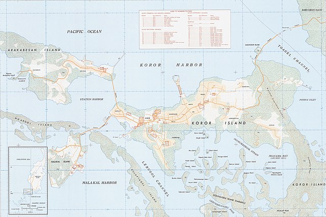
English: Map of Koror in the Caroline Islands (modern day Palau), 1:12,500 scale |
| Petsa | |
| Pinanggalingan | https://nla.gov.au/nla.obj-234178660/view |
| May-akda | Department of Defense, 652d Engineer Battalion |
Paglilisensiya
This image or file is a work of a U.S. Army Corps of Engineers soldier or employee, taken or made as part of that person's official duties. As a work of the U.S. federal government, the image is in the public domain.
|
Nakaraan ng file
Pindutin ang araw/oras upang makita kung papaano ang itsura ng talaksan noong oras na iyon.
| Araw/Oras | Thumbnail | Mga dimensiyon | tagagamit | Kumento | |
|---|---|---|---|---|---|
| ngayon | 14:53, 9 Hunyo 2021 | | 4,439 × 2,962 (2.56 MB) | Zoozaz1 | Uploaded a work by Department of Defense, 652d Engineer Battalion from https://nla.gov.au/nla.obj-234178660/view with UploadWizard |
Mga ugnay
Nakaturo sa talaksan na ito ang mga sumusunod na mga pahina:
Pandaigdigang paggamit sa file
Ginagamit ng mga sumusunod na wiki ang file na ito:
- Paggamit sa ar.wikipedia.org
- Paggamit sa arz.wikipedia.org
- Paggamit sa ca.wikipedia.org
- Paggamit sa en.wikipedia.org
- Paggamit sa eo.wikipedia.org
- Paggamit sa es.wikipedia.org
- Paggamit sa eu.wikipedia.org
- Paggamit sa ht.wikipedia.org
- Paggamit sa hu.wikipedia.org
- Paggamit sa pl.wikivoyage.org
- Paggamit sa pt.wikipedia.org
- Paggamit sa ro.wikipedia.org
- Paggamit sa th.wikipedia.org
- Paggamit sa vep.wikipedia.org
- Paggamit sa www.wikidata.org