
Talaksan:Krt 1510 full.jpg

Buong resolusyon ((4,555 × 3,292 pixel, laki ng talaksan: 1.81 MB, uri ng MIME: image/jpeg))
|
|
Ito ay isang talaksan mula sa Wikimedia Commons. Makikita sa ibaba ang impormasyon mula sa pahina ng paglalarawan nito roon. |
Buod
| Paglalarawan |
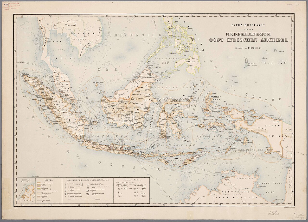
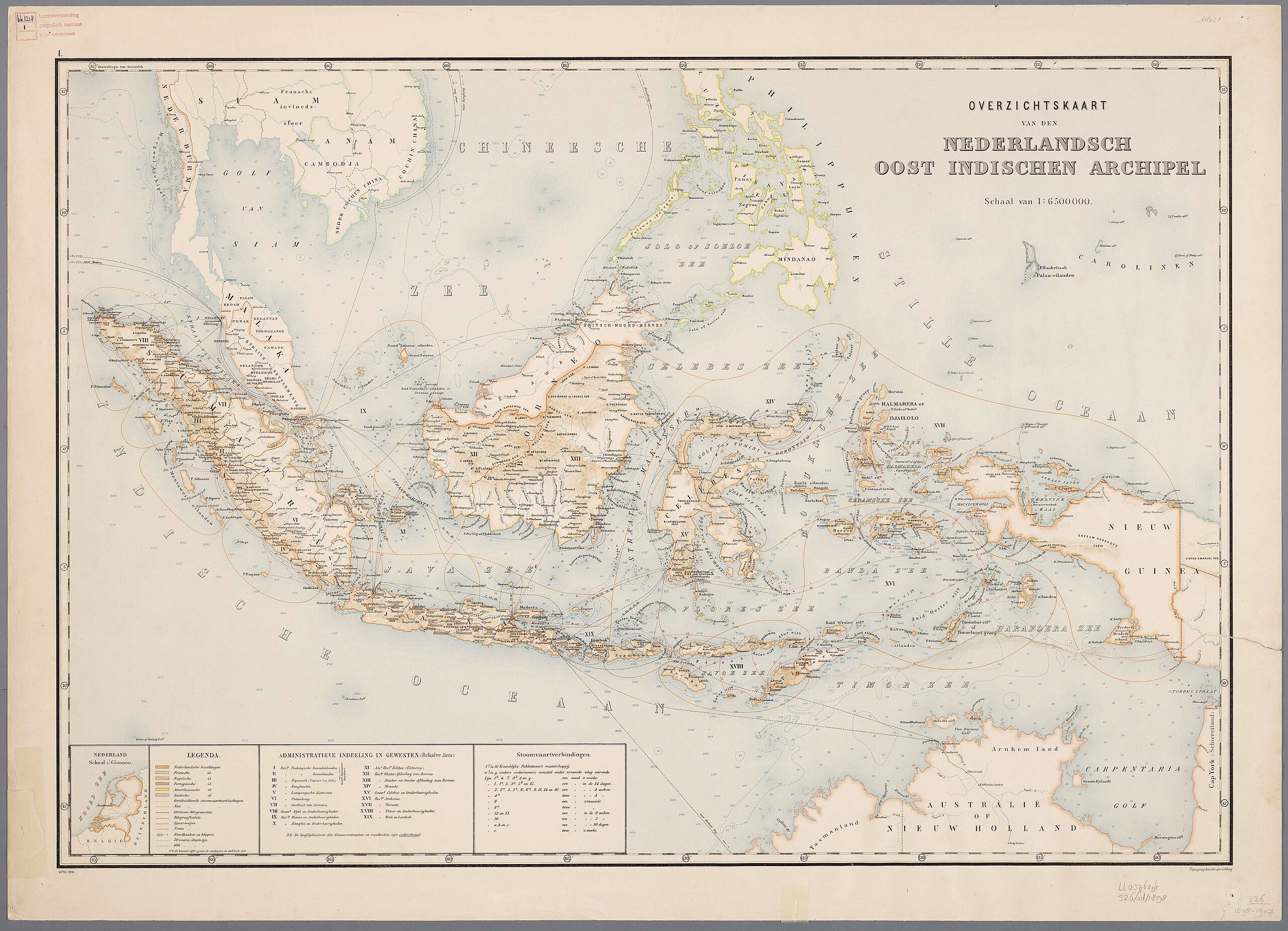
Nederlands: Atlas van Nederlandsch Oost-Indië / samengest. door Topographisch Bureau te Batavia van 1897-1904 |
| Petsa | 1897 - 1904 |
| Pinanggalingan | https://vu.contentdm.oclc.org/digital/collection/krt/id/1510 or https://digitalcollections.universiteitleiden.nl/view/item/2014658 |
| May-akda | Topographisch Bureau, Batavia |
| Iba pang mga bersyon |
.jpg)
.jpg)


|
This work is in the public domain in its country of origin and other countries and areas where the copyright term is the author's life plus 70 years or fewer. | |
| Nakilala ang talaksan bilang malaya mula sa nalalamang mga paghahangga sa ilalim ng batas sa karapatang-ari, kasama ang lahat ng mga kaugnay at karatig na mga karapatan. | |
Nakaraan ng file
Pindutin ang araw/oras upang makita kung papaano ang itsura ng talaksan noong oras na iyon.
| Araw/Oras | Thumbnail | Mga dimensiyon | tagagamit | Kumento | |
|---|---|---|---|---|---|
| ngayon | 11:54, 27 Hulyo 2024 | | 4,555 × 3,292 (1.81 MB) | Zacwill | Reverted to version as of 06:41, 8 August 2023 (UTC) the "restored" file has been transformatively altered and is thus not in the public domain |
| 06:44, 8 Agosto 2023 |  | 4,000 × 3,000 (14.13 MB) | Bennylin | restored and enchanced by u/helloVizart | |
| 06:41, 8 Agosto 2023 |  | 4,555 × 3,292 (1.81 MB) | Bennylin | {{Information |Description={{nl|Atlas van Nederlandsch Oost-Indië / samengest. door Topographisch Bureau te Batavia van 1897-1904<br /> 1. Overzichtskaart van den Nederlandsch Oost Indischen Archipel}} |Source=https://vu.contentdm.oclc.org/digital/collection/krt/id/1510 |Date=1897-1904 |Author=Topographisch Bureau, Batavia |Permission= |other_versions= }} {{PD-old}} Category:Old maps of Indonesia |
Mga ugnay
Nakaturo sa talaksan na ito ang mga sumusunod na mga pahina:
Pandaigdigang paggamit sa file
Ginagamit ng mga sumusunod na wiki ang file na ito:
- Paggamit sa arz.wikipedia.org
- Paggamit sa ast.wikipedia.org
- Paggamit sa ca.wikipedia.org
- Paggamit sa cy.wikipedia.org
- Paggamit sa dag.wikipedia.org
- Paggamit sa de.wikivoyage.org
- Paggamit sa diq.wikipedia.org
- Paggamit sa el.wikipedia.org
- Paggamit sa en.wikivoyage.org
- Paggamit sa eo.wikipedia.org
- Paggamit sa eo.wikinews.org
- Paggamit sa eo.wikiquote.org
- Paggamit sa fr.wikinews.org
- Paggamit sa fr.wikivoyage.org
- Paggamit sa ga.wikipedia.org
- Paggamit sa gl.wikipedia.org
- Paggamit sa ha.wikipedia.org
- Paggamit sa he.wikipedia.org
- Paggamit sa ia.wikipedia.org
- Paggamit sa incubator.wikimedia.org
- Paggamit sa it.wikipedia.org
- Paggamit sa kab.wikipedia.org
- Paggamit sa kcg.wikipedia.org
- Paggamit sa kl.wikipedia.org
- Paggamit sa ks.wikipedia.org
- Paggamit sa nqo.wikipedia.org
- Paggamit sa pcm.wikipedia.org
- Paggamit sa rue.wikipedia.org
- Paggamit sa tly.wikipedia.org
- Paggamit sa tr.wikiquote.org
- Paggamit sa vec.wikipedia.org
- Paggamit sa www.wikidata.org
- Q252
- Wikidata:WikiProject Movies/Numbers
- Wikidata:WikiProject Movies/Numbers/Most frequent P840
- Wikidata:WikiProject Movies/Numbers/Most frequent P915
- User:Zygimantus/Wikidata lists/Example2
- Wikidata:List of 1000 articles every Wikipedia should have
- Wikidata:WikiProject sum of all paintings/Top work locations
- User:Spinster/ASC Leiden Thesaurus
- Wikidata:WikiCite/Wikidata lists/Main subjects of publications with unidentified authors
- User:Walkuraxx/ASC Leiden Thesaurus