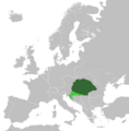
Talaksan:Lands of the Crown of Saint Stephen in 1914.png
Itsura

Laki ng pasilip na ito: 592 x 600 na pixel. Ibang resolusyon: 237 x 240 na pixel | 474 x 480 na pixel | 758 x 768 na pixel | 1,010 x 1,024 na pixel | 2,000 x 2,027 na pixel.
Buong resolusyon ((2,000 × 2,027 pixel, laki ng talaksan: 433 KB, uri ng MIME: image/png))
Nakaraan ng file
Pindutin ang araw/oras upang makita kung papaano ang itsura ng talaksan noong oras na iyon.
| Araw/Oras | Thumbnail | Mga dimensiyon | tagagamit | Kumento | |
|---|---|---|---|---|---|
| ngayon | 18:14, 18 Mayo 2021 |  | 2,000 × 2,027 (433 KB) | DonutEater13 | Actually fixed a small spot that was in the middle of the Adriatic sea since the first alteration. (uploaded wrong version first time) |
| 18:09, 18 Mayo 2021 |  | 2,000 × 2,027 (439 KB) | DonutEater13 | Reverted to version as of 12:57, 24 May 2019 (UTC) | |
| 18:00, 18 Mayo 2021 |  | 2,000 × 2,027 (433 KB) | DonutEater13 | Fixed a small spot that was in the middle of the Adriatic sea since the first alteration. | |
| 12:57, 24 Mayo 2019 |  | 2,000 × 2,027 (439 KB) | Koreanovsky | Since this map shows us the situation 1914 and Bosnia-Herzegovina was occupied by both Austria and Hungary, we would have to put a border over there. Otherwise it would look like an Cisleithanian crownland. | |
| 05:15, 17 Abril 2019 |  | 2,000 × 2,027 (553 KB) | Fakirbakir | Medimurje was Hungarian | |
| 00:11, 13 Mayo 2014 |  | 2,000 × 2,027 (551 KB) | Tezwoo | User created page with UploadWizard |
Mga ugnay
Nakaturo sa talaksan na ito ang mga sumusunod na mga pahina:
Pandaigdigang paggamit sa file
Ginagamit ng mga sumusunod na wiki ang file na ito:
- Paggamit sa ar.wikipedia.org
- Paggamit sa azb.wikipedia.org
- Paggamit sa az.wikipedia.org
- Paggamit sa bg.wikipedia.org
- Paggamit sa bn.wikipedia.org
- Paggamit sa cs.wikipedia.org
- Paggamit sa de.wikipedia.org
- Paggamit sa el.wikipedia.org
- Paggamit sa en.wikipedia.org
- Paggamit sa es.wikipedia.org
- Paggamit sa fi.wikipedia.org
- Paggamit sa fr.wikipedia.org
- Paggamit sa he.wikipedia.org
- Paggamit sa hr.wikipedia.org
- Paggamit sa hu.wikipedia.org
- Paggamit sa hy.wikipedia.org
- Paggamit sa id.wikipedia.org
- Paggamit sa io.wikipedia.org
- Paggamit sa ko.wikipedia.org
- Paggamit sa lv.wikipedia.org
- Paggamit sa nl.wikipedia.org
- Paggamit sa pl.wikipedia.org
- Paggamit sa pl.wiktionary.org
- Paggamit sa pt.wikipedia.org
- Paggamit sa ro.wikipedia.org
- Paggamit sa rue.wikipedia.org
- Paggamit sa ru.wikipedia.org
- Paggamit sa sco.wikipedia.org
- Paggamit sa simple.wikipedia.org
- Paggamit sa si.wikipedia.org
- Paggamit sa sq.wikipedia.org
- Paggamit sa sr.wikipedia.org
- Paggamit sa sv.wikipedia.org
- Paggamit sa ta.wikipedia.org
- Paggamit sa th.wikipedia.org
- Paggamit sa tr.wikipedia.org
- Paggamit sa tt.wikipedia.org
- Paggamit sa vi.wikipedia.org
- Paggamit sa zh.wikipedia.org

