
Talaksan:Médio-assyrien.png

Laki ng pasilip na ito: 731 x 599 na pixel. Ibang resolusyon: 293 x 240 na pixel | 586 x 480 na pixel | 883 x 724 na pixel.
Buong resolusyon ((883 × 724 pixel, laki ng talaksan: 724 KB, uri ng MIME: image/png))
|
|
Ito ay isang talaksan mula sa Wikimedia Commons. Makikita sa ibaba ang impormasyon mula sa pahina ng paglalarawan nito roon. |
| Paglalarawan |
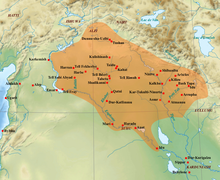
English: Map of the medio-assyrian kingdom (End of the 13th- beginning of the 11th centuries BC). Français : Carte des limites approximatives du royaume médio-assyrien à son apogée (Fin XIIIe-début XIe siècles av. J.-C.). Sources utilisées : Bertrand Lafont, Aline Tenu, Philippe Clancier et Francis Joannès, Mésopotamie : De Gilgamesh à Artaban (3300-120 av. J.-C.), Paris, Belin, coll. « Mondes anciens », 2017, p. 531 ; John Nicholas Postgate, Bronze Age Bureaucracy: Writing and the Practice of Government in Assyria, Cambridge, Cambridge University Press, 2013, p. 31 ; Martin Sauvage (dir.), Atlas historique du Proche-Orient ancien, Paris, Les Belles Lettres, 2020, p. 102. |
| Petsa | (UTC) |
| Pinanggalingan | |
| May-akda |
|
| Iba pang mga bersyon | File:Medio assyrien.svg |
| This is a retouched picture, which means that it has been digitally altered from its original version. Modifications: Ajout des limites du royaume médio-assyrien et des villes et sites archéologiques principaux.. The original can be viewed here: Near East topographic map-blank.svg:
|
Ako, na may karapatang-ari ng akdang ito, ang naglalathala nito alinsunod sa ilalim ng sumusunod na mga lisensya:
Ang talaksang ito ay nakalisensiya sa ilalim ng lisensiyang Creative Commons Atribusyon-Pagpapamahaging Magkatulad 3.0 Walang Daungan, 2.5 Heneriko, 2.0 Heneriko at 1.0 Heneriko.
- Malaya kang:
- para ibahagi – para kopyahin, ipamahagi, at i-transmit ang akda
- para i-remix – para i-adapt ang akda
- Sa ilalim ng mga kondisyong ito:
- atribusyon – Dapat magbigay ka ng isang maayos na pag-credit, ibigay ang link sa lisensiya, at tukuyin kung may mga pagbabagong ginawa. Magagawa mo ito sa isang risonableng paraan, pero hindi sa paraan na para bang ineendorso ka o ng paggamit mo ng naglisensiya sa'yo.
- share alike – Kung ire-remix mo, babaguhin, o magdadagdag ka sa materyal, dapat mong ipamahagi ang mga ambag mo sa ilalim ng pareho o katulad na lisensiya.

|
Pinapayagan ang pagkopya, pamamahagi, at/o pagbabago sa dokumentong ito sa ilalim ng mga nakasaad sa GNU Free Documentation License, Bersyon 1.2 o kahit anong mas bagong bersyong nilathala ng Free Software Foundation; nang walang pabago-bagong bahagi, walang teksto sa front-cover, at walang teksto sa back-cover. May nakalagay na kopya ng lisensiya sa bahaging pinamagatang GNU Free Documentation License. |
Makakapili ka ng lisensiyang gusto mo.
Tala ng orihinal na pagkarga
This image is a derivative work of the following images:
- File:Near_East_topographic_map-blank.svg licensed with Cc-by-sa-3.0,2.5,2.0,1.0, GFDL
- 2009-08-18T18:31:37Z Sémhur 2425x1581 (2442670 Bytes) 3 - New try
- 2009-08-17T15:39:22Z Sémhur 2425x1581 (1815374 Bytes) 2 - With the background...
- 2009-08-17T15:37:36Z Sémhur 2425x1581 (2836 Bytes) {{Information |Description={{en|1=Blank physical map of the [[:en:Near East|Near East]]}} {{fr|1=Carte physique vierge du [[:fr:Proche-Orient|Proche-Orient]].}} |Source={{own}} |Author=[[User:Sémhur|Sémhur]] |Date=2008-08-1
Uploaded with derivativeFX
Nakaraan ng file
Pindutin ang araw/oras upang makita kung papaano ang itsura ng talaksan noong oras na iyon.
| Araw/Oras | Thumbnail | Mga dimensiyon | tagagamit | Kumento | |
|---|---|---|---|---|---|
| ngayon | 10:21, 7 Marso 2022 | | 883 × 724 (724 KB) | Zunkir | ajouts et modifs |
| 20:59, 1 Pebrero 2018 |  | 883 × 724 (714 KB) | Zunkir | Nouveaux sites, tracé, localisations. | |
| 13:16, 23 Setyembre 2010 |  | 1,179 × 951 (1.6 MB) | Zunkir | Mise en couleur du royaume médio-assyrien, renommage de certains sites suivant leur nom antique. | |
| 12:48, 21 Setyembre 2010 |  | 1,263 × 888 (1.73 MB) | Zunkir | {{Information |Description={{en|1=Map of the medio-assyrian kingdom (13th-12th centuries BC).}} {{fr|1=Carte des limites approximatives du royaume médio-assyrien à son apogée (XIIIe-XIIe siècles av. J.-C.).}} |Source=*[[:File:Near_East_topographic_map |
Mga ugnay
Nakaturo sa talaksan na ito ang mga sumusunod na mga pahina:
Pandaigdigang paggamit sa file
Ginagamit ng mga sumusunod na wiki ang file na ito:
- Paggamit sa ar.wikipedia.org
- Paggamit sa bn.wikipedia.org
- Paggamit sa ca.wikipedia.org
- Paggamit sa cs.wikipedia.org
- Paggamit sa de.wikipedia.org
- Paggamit sa en.wikipedia.org
- Paggamit sa es.wikipedia.org
- Paggamit sa fa.wikipedia.org
- Paggamit sa fr.wikipedia.org
- Paggamit sa hr.wikipedia.org
- Paggamit sa hu.wikipedia.org
- Paggamit sa hy.wikipedia.org
- Paggamit sa id.wikipedia.org
- Paggamit sa it.wikipedia.org
- Paggamit sa ja.wikipedia.org
- Paggamit sa ko.wikipedia.org
- Paggamit sa lt.wikipedia.org
- Paggamit sa nl.wikipedia.org
- Paggamit sa pl.wikipedia.org
- Paggamit sa pt.wikipedia.org
Tingnan ang karagdagang pandaigdigang paggamit sa file na ito.