
Talaksan:Namibia map.png
Walang resolusyong mataas.
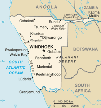
Namibia_map.png ((326 × 349 pixel, laki ng talaksan: 19 KB, uri ng MIME: image/png))
|
|
Ito ay isang talaksan mula sa Wikimedia Commons. Makikita sa ibaba ang impormasyon mula sa pahina ng paglalarawan nito roon. |
CIA map of Namibia
- See also the 2004 version.
.png)
This image is in the public domain because it contains materials that originally came from the United States Central Intelligence Agency's World Factbook.
|
 |
derivative works
Derivative works of this file: Namibia map-sv.png
Nakaraan ng file
Pindutin ang araw/oras upang makita kung papaano ang itsura ng talaksan noong oras na iyon.
| Araw/Oras | Thumbnail | Mga dimensiyon | tagagamit | Kumento | |
|---|---|---|---|---|---|
| ngayon | 10:17, 17 Enero 2022 | | 326 × 349 (19 KB) | Lojwe | Cropped 1 % horizontally, 1 % vertically using CropTool with precise mode. |
| 07:59, 21 Hulyo 2007 |  | 328 × 353 (20 KB) | Hoshie | Updated map of Namibia from the CIA World Factbook, 14 June 07 rev. Src: https://www.cia.gov/library/publications/the-world-factbook/maps/wa-map.gif | |
| 20:51, 4 Marso 2005 |  | 330 × 355 (9 KB) | Alfio | CIA map of Namibia |
Mga ugnay
Nakaturo sa talaksan na ito ang mga sumusunod na mga pahina:
Pandaigdigang paggamit sa file
Ginagamit ng mga sumusunod na wiki ang file na ito:
- Paggamit sa af.wikipedia.org
- Paggamit sa ar.wikipedia.org
- Paggamit sa bg.wikipedia.org
- Paggamit sa ca.wikipedia.org
- Paggamit sa da.wikipedia.org
- Paggamit sa de.wikipedia.org
- Paggamit sa dsb.wikipedia.org
- Paggamit sa en.wikipedia.org
- Paggamit sa fi.wikipedia.org
- Paggamit sa fr.wikipedia.org
- Paggamit sa hif.wikipedia.org
- Paggamit sa hr.wikipedia.org
- Paggamit sa hu.wikipedia.org
- Paggamit sa hu.wiktionary.org
- Paggamit sa incubator.wikimedia.org
- Paggamit sa it.wikipedia.org
- Paggamit sa ja.wikipedia.org
- Paggamit sa ka.wikipedia.org
- Paggamit sa kg.wikipedia.org
- Paggamit sa kn.wikipedia.org
Tingnan ang karagdagang pandaigdigang paggamit sa file na ito.