
Talaksan:New 2000 black density.gif

Buong resolusyon ((2,604 × 2,012 pixel, laki ng talaksan: 620 KB, uri ng MIME: image/gif))
|
|
Ito ay isang talaksan mula sa Wikimedia Commons. Makikita sa ibaba ang impormasyon mula sa pahina ng paglalarawan nito roon. |

|
This ethnographic map image could be re-created using vector graphics as an SVG file. This has several advantages; see Commons:Media for cleanup for more information. If an SVG form of this image is available, please upload it and afterwards replace this template with
{{vector version available|new image name}}.
It is recommended to name the SVG file “New 2000 black density.svg”—then the template Vector version available (or Vva) does not need the new image name parameter. |
Buod
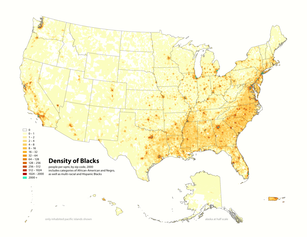
Map of contiguous US, showing density of self-reported "Black" population, in persons per square mile, by census tract, 2000. Data source: US Census.
I (user:Citynoice) am the designer and creator of this map and license it under the Creative Commons Attribution ShareAlike 2.5 License.
similar maps:
- w:Image:New 2000 asian density.gif
- w:Image:New 2000 asian percent.gif
- w:Image:New 2000 black density.gif
- w:Image:New 2000 black percent.gif
- w:Image:New 2000 hawaiian density.gif
- w:Image:New 2000 hawaiian percent.gif
- w:Image:New 2000 hispanic density.gif
- w:Image:New 2000 hispanic percent.gif
- w:Image:New 2000 indian density.gif
- w:Image:New 2000 indian percent.gif
- w:Image:New 2000 white density.gif
- w:Image:New 2000 white percent.gif
Paglilisensiya
- Malaya kang:
- para ibahagi – para kopyahin, ipamahagi, at i-transmit ang akda
- para i-remix – para i-adapt ang akda
- Sa ilalim ng mga kondisyong ito:
- atribusyon – Dapat magbigay ka ng isang maayos na pag-credit, ibigay ang link sa lisensiya, at tukuyin kung may mga pagbabagong ginawa. Magagawa mo ito sa isang risonableng paraan, pero hindi sa paraan na para bang ineendorso ka o ng paggamit mo ng naglisensiya sa'yo.
- share alike – Kung ire-remix mo, babaguhin, o magdadagdag ka sa materyal, dapat mong ipamahagi ang mga ambag mo sa ilalim ng pareho o katulad na lisensiya.
Nakaraan ng file
Pindutin ang araw/oras upang makita kung papaano ang itsura ng talaksan noong oras na iyon.
| Araw/Oras | Thumbnail | Mga dimensiyon | tagagamit | Kumento | |
|---|---|---|---|---|---|
| ngayon | 19:14, 1 Mayo 2010 | | 2,604 × 2,012 (620 KB) | Citynoise | Added Alaska, Hawaii, and Territories. Also changed from tracts to zip codes. |
| 13:40, 25 Setyembre 2006 |  | 1,012 × 691 (99 KB) | CyberAngel | == Dettagli == {{Information| |Description={{en}} '''w:Republic of the New Afrika''' (RNA). Map of contiguous US, showing density of self-reported "Black" population, in persons per square mile, by census tract, 2000. ''Data source:'' US Census. {{it} |
Mga ugnay
Nakaturo sa talaksan na ito ang mga sumusunod na mga pahina:
Pandaigdigang paggamit sa file
Ginagamit ng mga sumusunod na wiki ang file na ito:
- Paggamit sa de.wikiversity.org
- Paggamit sa en.wikipedia.org
- Paggamit sa fa.wikipedia.org
- Paggamit sa fr.wikipedia.org
- Paggamit sa gl.wikipedia.org
- Paggamit sa it.wikipedia.org
- Paggamit sa ja.wikipedia.org
- Paggamit sa nl.wikipedia.org
- Paggamit sa pl.wikipedia.org
- Paggamit sa pt.wikipedia.org
- Paggamit sa ur.wikipedia.org