
Talaksan:Occupied Palestinian Territories.jpg

Laki ng pasilip na ito: 393 x 599 na pixel. Ibang resolusyon: 157 x 240 na pixel | 315 x 480 na pixel | 504 x 768 na pixel | 672 x 1,024 na pixel | 1,895 x 2,889 na pixel.
Buong resolusyon ((1,895 × 2,889 pixel, laki ng talaksan: 949 KB, uri ng MIME: image/jpeg))
|
|
Ito ay isang talaksan mula sa Wikimedia Commons. Makikita sa ibaba ang impormasyon mula sa pahina ng paglalarawan nito roon. |
Buod
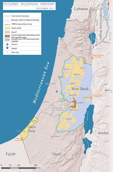
| Paglalarawan |
English: Map of the Occupied Palestinian Territories (West Bank and Gaza Strip), marked by the Green Line. Based on Reference Map: occupied Palestinian territory: Overview Map, as of December 2011. Published by United Nations Office for the Coordination of Humanitarian Affairs (OCHAoPt), 25 January 2012
العربية: خريطة للأراضي الفلسطينية المحتلة (الضفة الغربية وقطاع غزة) ، مميزة بالخط الأخضر. استنادًا إلى الخريطة المرجعية: "الأراضي الفلسطينية المحتلة: خريطة عامة" ، اعتبارًا من ديسمبر 2011. تم النشر بواسطة مكتب الأمم المتحدة لتنسيق الشؤون الإنسانية (OCHAoPt ) ، 25 يناير 2012 |
| Petsa | |
| Pinanggalingan | Sariling gawa, based on http://www.ochaopt.org/documents/ochaopt_atlas_opt_general_december2011.pdf on [1] |
| May-akda | Wickey-nl |

|
This map image could be re-created using vector graphics as an SVG file. This has several advantages; see Commons:Media for cleanup for more information. If an SVG form of this image is available, please upload it and afterwards replace this template with
{{vector version available|new image name}}.
It is recommended to name the SVG file “Occupied Palestinian Territories.svg”—then the template Vector version available (or Vva) does not need the new image name parameter. |


Paglilisensiya
Ako, na may karapatang-ari ng akdang ito, ang naglalathala nito alinsunod sa ilalim ng sumusunod na mga lisensya:
Lisensyado ang file na ito sa ilalim ng lisensiyang Creative Commons Attribution-Share Alike 3.0 Unported.
- Malaya kang:
- para ibahagi – para kopyahin, ipamahagi, at i-transmit ang akda
- para i-remix – para i-adapt ang akda
- Sa ilalim ng mga kondisyong ito:
- atribusyon – Dapat magbigay ka ng isang maayos na pag-credit, ibigay ang link sa lisensiya, at tukuyin kung may mga pagbabagong ginawa. Magagawa mo ito sa isang risonableng paraan, pero hindi sa paraan na para bang ineendorso ka o ng paggamit mo ng naglisensiya sa'yo.
- share alike – Kung ire-remix mo, babaguhin, o magdadagdag ka sa materyal, dapat mong ipamahagi ang mga ambag mo sa ilalim ng pareho o katulad na lisensiya.

Nakaraan ng file
Pindutin ang araw/oras upang makita kung papaano ang itsura ng talaksan noong oras na iyon.
| Araw/Oras | Thumbnail | Mga dimensiyon | tagagamit | Kumento | |
|---|---|---|---|---|---|
| ngayon | 17:08, 25 Marso 2014 | | 1,895 × 2,889 (949 KB) | Wickey-nl | User created page with UploadWizard |
Mga ugnay
Nakaturo sa talaksan na ito ang mga sumusunod na mga pahina:
Pandaigdigang paggamit sa file
Ginagamit ng mga sumusunod na wiki ang file na ito:
- Paggamit sa af.wikipedia.org
- Paggamit sa ar.wikipedia.org
- Paggamit sa az.wikipedia.org
- Paggamit sa bh.wikipedia.org
- Paggamit sa bn.wikipedia.org
- Paggamit sa bug.wikipedia.org
- Paggamit sa cs.wikipedia.org
- Paggamit sa da.wikipedia.org
- Paggamit sa de.wikipedia.org
- Paggamit sa el.wikipedia.org
- Paggamit sa en.wikipedia.org
- Israeli–Palestinian conflict
- Palestinian territories
- Israeli-occupied territories
- Frozen conflict
- United Nations Security Council Resolution 1515
- Talk:Israeli–Palestinian conflict/Archive 18
- United States involvement in regime change
- Boycott, Divestment and Sanctions
- Two-state solution
- Talk:State of Palestine/Archive 12
- Freedom of religion in Asia by country
- User:Falcaorib
- From the river to the sea
- User:Christophervincent01
- Paggamit sa es.wikipedia.org
- Paggamit sa et.wikipedia.org
- Paggamit sa fa.wikipedia.org
- Paggamit sa fi.wikipedia.org
- Paggamit sa fy.wikipedia.org
- Paggamit sa gl.wikipedia.org
- Paggamit sa he.wikipedia.org
- Paggamit sa hu.wikipedia.org
- Paggamit sa id.wikipedia.org
- Paggamit sa io.wikipedia.org
- Paggamit sa it.wikipedia.org
- Paggamit sa ja.wikipedia.org
- Paggamit sa la.wikipedia.org
Tingnan ang karagdagang pandaigdigang paggamit sa file na ito.