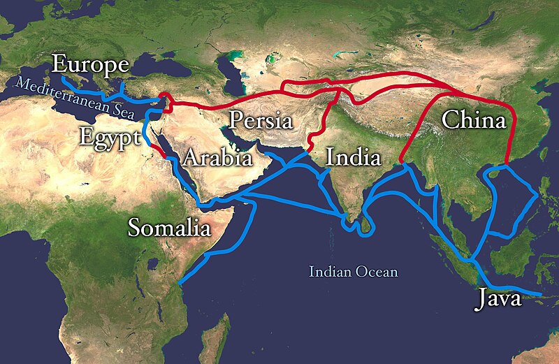
Talaksan:Silk route.jpg

Laki ng pasilip na ito: 800 x 521 na pixel. Ibang resolusyon: 320 x 208 na pixel | 640 x 416 na pixel | 1,024 x 666 na pixel | 1,280 x 833 na pixel | 2,868 x 1,866 na pixel.
Buong resolusyon ((2,868 × 1,866 pixel, laki ng talaksan: 819 KB, uri ng MIME: image/jpeg))
Nakaraan ng file
Pindutin ang araw/oras upang makita kung papaano ang itsura ng talaksan noong oras na iyon.
| Araw/Oras | Thumbnail | Mga dimensiyon | tagagamit | Kumento | |
|---|---|---|---|---|---|
| ngayon | 10:38, 4 Hulyo 2018 |  | 2,868 × 1,866 (819 KB) | Bongan | sea route modify because of Rama Setu ({{Adam's Bridge}}) |
| 14:01, 8 Pebrero 2018 |  | 2,868 × 1,866 (1.57 MB) | Darwgon0801 | Reverted to version as of 17:45, 30 December 2012 (UTC) | |
| 07:42, 22 Nobyembre 2017 |  | 2,868 × 1,866 (2.06 MB) | Ibrahim Muizzuddin | Reverted to version as of 13:19, 12 April 2012 (UTC) Revert to more credible version | |
| 17:45, 30 Disyembre 2012 |  | 2,868 × 1,866 (1.57 MB) | 23prootie~commonswiki | Adding Brunei and the Lucoes | |
| 13:19, 12 Abril 2012 |  | 2,868 × 1,866 (2.06 MB) | Splette | correct typo | |
| 10:15, 12 Abril 2012 |  | 2,868 × 1,866 (2.06 MB) | Splette | correct the position of the 'Somalia' label | |
| 04:51, 27 Mayo 2010 |  | 2,868 × 1,866 (1.93 MB) | Splette | one more try... better contrast | |
| 04:45, 27 Mayo 2010 |  | 2,868 × 1,866 (1.94 MB) | Splette | change colors | |
| 04:37, 27 Mayo 2010 |  | 2,868 × 1,866 (1.93 MB) | Splette | {{Information |Description=Extent of Silk Route/Silk Road. Red is land route and the blue is the sea/water route. |Source=*File:Whole_world_-_land_and_oceans_12000.jpg |Date=2010-05-27 04:33 (UTC) |Author=*[[:File:Whole_world_-_land_and_oceans_12000 |
Mga ugnay
Nakaturo sa talaksan na ito ang mga sumusunod na mga pahina:
Pandaigdigang paggamit sa file
Ginagamit ng mga sumusunod na wiki ang file na ito:
- Paggamit sa af.wikipedia.org
- Paggamit sa anp.wikipedia.org
- Paggamit sa ast.wikipedia.org
- Paggamit sa azb.wikipedia.org
- Paggamit sa az.wikipedia.org
- Paggamit sa ba.wikipedia.org
- Paggamit sa be-tarask.wikipedia.org
- Paggamit sa bg.wikipedia.org
- Paggamit sa bn.wikipedia.org
- Paggamit sa bs.wikipedia.org
- Paggamit sa ca.wikipedia.org
- Paggamit sa ce.wikipedia.org
- Paggamit sa chr.wikipedia.org
- Paggamit sa crh.wikipedia.org
- Paggamit sa da.wikipedia.org
- Paggamit sa de.wikipedia.org
- Paggamit sa el.wikipedia.org
- Paggamit sa el.wikivoyage.org
- Paggamit sa en.wikipedia.org
Tingnan ang karagdagang pandaigdigang paggamit sa file na ito.


