
Talaksan:Thomas Circle - Washington, D.C..jpg

Buong resolusyon ((5,672 × 3,944 pixel, laki ng talaksan: 4.97 MB, uri ng MIME: image/jpeg))
|
|
Ito ay isang talaksan mula sa Wikimedia Commons. Makikita sa ibaba ang impormasyon mula sa pahina ng paglalarawan nito roon. |
Buod
| Paglalarawan |
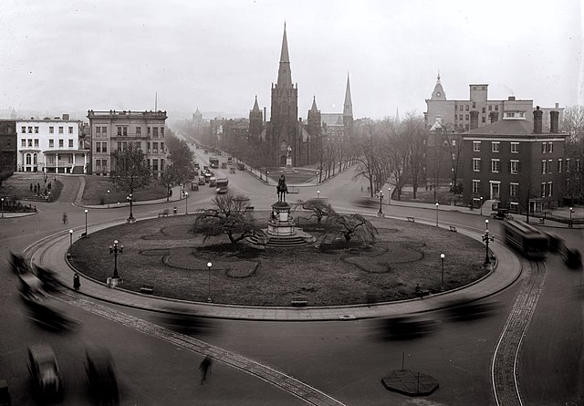
Looking north past Thomas Circle in Washington, D.C. as viewed from the Portland Flats (demolished; built in 1880 and designed by Adolf Cluss; city's first apartment building). The traffic circle is located at the junction of 14th Street (visible on the lower right and center left), Massachusetts Avenue (right and left sides), Vermont Avenue (lower left and center right), and M Street (bottom right and bottom left), NW. The equestrian statue seen in this image was erected in 1879 and honors General George Henry Thomas. The streetcar lines wrapping around the Circle on 14th Street were installed in the 1890s, but no longer exist. The homes visible on either side of the Circle have been demolished. National City Christian Church, designed by John Russell Pope in 1930, now stands on the Circle's west side and is a contributing property to the Greater Fourteenth Street Historic District. The Wylie House, seen on the right, was demolished in 1947 and replaced with the nine-story Washington Plaza Hotel designed by Morris Lapidus. The taller church seen directly across the Circle is Luther Place Memorial Church (originally known as Memorial Evangelical Lutheran Church), built in 1873 and listed on the National Register of Historic Places. A statue honoring Martin Luther is located in front of the church. It was a gift from the German emperor in 1884 and is a replica of the Martin Luther statue in Worms, Germany. Directly behind Luther Place is Mount Olivet Lutheran Church, a contributing property to the Logan Circle Historic District. The building was constructed in 1884 and originally home to the Vermont Avenue Christian Church (original name for the National City Christian Church). Mount Olivet purchased the property in 1953. The two remaining landmarks that can be seen in this image include Vermont Avenue Baptist Church (look NE on Vermont; the steeple is visible) and John Wesley AME Zion Church (look north on 14th Street; the steeple is also visible). Both buildings are contributing properties to the Greater Fourteenth Street Historic District. |
||
| Petsa | |||
| Pinanggalingan |
|
||
| May-akda | National Photo Company | ||
| Iba pang mga bersyon |
Derivative works of this file: |


Paglilisensiya
This work is in the public domain in the United States because it is a work prepared by an officer or employee of the United States Government as part of that person’s official duties under the terms of Title 17, Chapter 1, Section 105 of the US Code.
Note: This only applies to original works of the Federal Government and not to the work of any individual U.S. state, territory, commonwealth, county, municipality, or any other subdivision. This template also does not apply to postage stamp designs published by the United States Postal Service since 1978. (See § 313.6(C)(1) of Compendium of U.S. Copyright Office Practices). It also does not apply to certain US coins; see The US Mint Terms of Use.
|
 | |
| Nakilala ang talaksan bilang malaya mula sa nalalamang mga paghahangga sa ilalim ng batas sa karapatang-ari, kasama ang lahat ng mga kaugnay at karatig na mga karapatan. | ||
Nakaraan ng file
Pindutin ang araw/oras upang makita kung papaano ang itsura ng talaksan noong oras na iyon.
| Araw/Oras | Thumbnail | Mga dimensiyon | tagagamit | Kumento | |
|---|---|---|---|---|---|
| ngayon | 11:21, 5 Pebrero 2009 | | 5,672 × 3,944 (4.97 MB) | APK | {{Information |Description=Looking north past Thomas Circle in Washington, D.C. as viewed from the Portland Flats (demolished; built in 1880 and designed by Adolf Cluss; city's first apartment building). The traffic circle is located at the junction of 14 |
Mga ugnay
Nakaturo sa talaksan na ito ang mga sumusunod na mga pahina:
Pandaigdigang paggamit sa file
Ginagamit ng mga sumusunod na wiki ang file na ito:
- Paggamit sa ceb.wikipedia.org
- Paggamit sa en.wikipedia.org
- Paggamit sa fr.wikipedia.org
- Paggamit sa www.wikidata.org