
Talaksan:Typhoon Utor 2013 making landfall.gif
Walang resolusyong mataas.
Typhoon_Utor_2013_making_landfall.gif ((720 × 480 pixel, laki ng talaksan: 3.6 MB, uri ng MIME: image/gif), nasilo na, 15 banhay, 3.1 segundo)
|
|
Ito ay isang talaksan mula sa Wikimedia Commons. Makikita sa ibaba ang impormasyon mula sa pahina ng paglalarawan nito roon. |
Buod
| Paglalarawan |
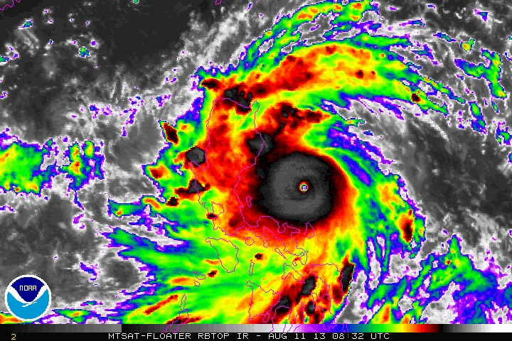
English: Animated enhanced infrared satellite loop of Typhoon Utor (also known as Typhoon Labuyo in the Philippines) from 0832 UTC on August 11 to 2232 UTC August 11, 2013. These images show the storm at peak intensity and making landfall in the Luzon. |
| Petsa | |
| Pinanggalingan | http://www.ssd.noaa.gov/PS/TROP/floaters/ |
| May-akda | National Oceanic and Atmospheric Administration Satellite Services Division |
Paglilisensiya
This image is in the public domain because it contains materials that originally came from the U.S. National Oceanic and Atmospheric Administration, taken or made as part of an employee's official duties.
|
Nakaraan ng file
Pindutin ang araw/oras upang makita kung papaano ang itsura ng talaksan noong oras na iyon.
| Araw/Oras | Thumbnail | Mga dimensiyon | tagagamit | Kumento | |
|---|---|---|---|---|---|
| ngayon | 03:01, 12 Agosto 2013 | | 720 × 480 (3.6 MB) | Kwlam259 | User created page with UploadWizard |
Mga ugnay
Nakaturo sa talaksan na ito ang mga sumusunod na mga pahina:
Pandaigdigang paggamit sa file
Ginagamit ng mga sumusunod na wiki ang file na ito:
- Paggamit sa en.wikipedia.org
- Paggamit sa zh.wikipedia.org