
Talaksan:China's 2009 nine-dash line map submission to the UN.pdf

Buong resolusyon ((1,275 × 1,650 pixel, laki ng talaksan: 412 KB, uri ng MIME: application/pdf))
|
|
Ito ay isang talaksan mula sa Wikimedia Commons. Makikita sa ibaba ang impormasyon mula sa pahina ng paglalarawan nito roon. |
Buod
| Paglalarawan |
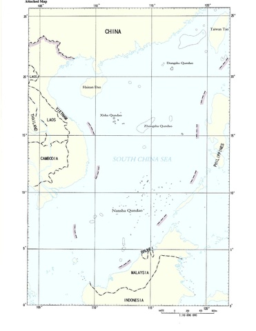
English: Document “CML/17/2009” May 7, 2009, submitted by the People's Republic of China to the United Nations Commission on the Limits of the Continental Shelf. The map here is the second page in a two-page document. The first page is a text addressed to the UN Secretary General, noting China's sovereignty claim to the "islands in the South China Sea and the adjacent waters", however, the document remains ambiguous by being silent as to the precise meaning of the map enclosed, and the meaning of the nine-dash line on it |
| Petsa | 05/07/2009 |
| Pinanggalingan | United Nations - http://www.un.org/depts/los/clcs_new/submissions_files/mysvnm33_09/chn_2009re_mys_vnm_e.pdf |
| May-akda | Unknown author |
Paglilisensiya
| This image is a map derived from a United Nations map.
Unless stated otherwise, UN maps are to be considered in the public domain. This applies worldwide. UN maps are, in principle, open source material and you can use them in your work or for making your own map. UN requests however that you delete the UN name, logo and reference number upon any modification to the map. Content of your map will be your responsibility. You can state in your publication, if you wish, something like: based on UN map … (map name, map number, revision number and date). See: Geospatial Information Section. And: Geospatial, location data for a better world. |
 |
Nakaraan ng file
Pindutin ang araw/oras upang makita kung papaano ang itsura ng talaksan noong oras na iyon.
| Araw/Oras | Thumbnail | Mga dimensiyon | tagagamit | Kumento | |
|---|---|---|---|---|---|
| ngayon | 16:02, 20 Pebrero 2015 |  | 1,275 × 1,650 (412 KB) | Al83tito | User created page with UploadWizard |
Mga ugnay
Nakaturo sa talaksan na ito ang mga sumusunod na mga pahina:
Pandaigdigang paggamit sa file
Ginagamit ng mga sumusunod na wiki ang file na ito:
- Paggamit sa ca.wikipedia.org
- Paggamit sa el.wikipedia.org
- Paggamit sa en.wikipedia.org
- Paggamit sa es.wikipedia.org
- Paggamit sa et.wikipedia.org
- Paggamit sa fr.wikipedia.org
- Paggamit sa id.wikipedia.org
- Paggamit sa pl.wikipedia.org
- Paggamit sa ru.wikipedia.org
- Paggamit sa uk.wikipedia.org